Community Corner
3-5 Inches of Snow, Ice for Lexington This Weekend
State officials warned the heavy, wet snow could exacerbate roof collapses.

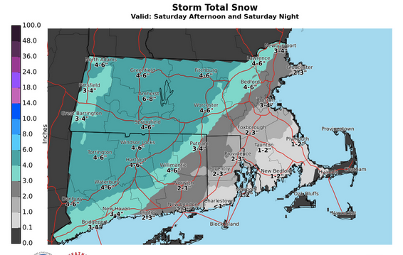
About 4-6 inches of snow will hit the region starting Saturday night.
The National Weather Service issued a winter weather advisory for the region, saying heavy, wet snow could exacerbate roof collapses.In the last week, there have been more than 100 full or partial roof collapses across the state, according to state officials. In Westford Friday, a barn collapsed, killed two horses.
Find out what's happening in Lexingtonfor free with the latest updates from Patch.
Here’s more from NWS:
- A WINTER WEATHER ADVISORY FOR SNOW AND/OR FREEZING RAIN...IS IN EFFECT FROM 1 PM SATURDAY TO 1 PM EST SUNDAY.
- LOCATIONS...INCLUDE ALL OF SOUTHERN NEW ENGLAND EXCEPT CAPE COD AND THE ISLANDS. * HAZARD TYPES...SNOW AND FREEZING RAIN.
- ACCUMULATIONS...SNOW ACCUMULATION OF AROUND 3 TO 5 INCHES... WITH THE POTENTIAL OF A TRACE UP TO A TENTH OF AN INCH OF ICE ACCUMULATION.
- TIMING...LATE SATURDAY BEGINNING AS SNOW...TRANSITIONING TO A SNOW - FREEZING RAIN MIX...PERHAPS EVEN PLAIN RAIN...SATURDAY NIGHT THROUGH MIDDAY SUNDAY.
- IMPACTS...ANY SNOW / ICE WILL MAKE FOR SLICK SURFACES AND HAZARDOUS TRAVEL CONDITIONS. WITH THE THREAT OF A WET SNOW AND/OR RAIN...STRUCTURAL COLLAPSES WILL BE POSSIBLE FOR THOSE ROOFS THAT HAVE A REMNANT SNOWPACK. RAIN ALONE PRESENTS THE THREAT OF URBAN POOR DRAINAGE FLOODING AS DRAINS ARE SNOW- CLOGGED.
- WINDS...SOUTHWEST 10 TO 15 MPH WITH GUSTS UP TO 25 MPH.
- TEMPERATURES...IN THE UPPER 20S TO LOWER 30S.
Photo credit: National Weather Service
Find out what's happening in Lexingtonfor free with the latest updates from Patch.
Get more local news delivered straight to your inbox. Sign up for free Patch newsletters and alerts.