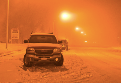
After a blizzard dropped about a foot of snow on Lexington by Sunday morning, temperatures will plummet at night.
The National Weather Service issued a wind chill warning, saying wind chill values will drop to as low as 22 below zero.
Here’s more from NWS:
Find out what's happening in Lexingtonfor free with the latest updates from Patch.
- A WIND CHILL WARNING...IS IN EFFECT FROM SUNDAY AT 4 PM TO MONDAY AT 8 AM
- WIND CHILL...27 BELOW ZERO.
- HAZARD TYPES...BLOWING SNOW LEADING TO OCCASIONAL BLIZZARD CONDITIONS.
- ACCUMULATIONS...NO ADDITIONAL ACCUMULATION IS EXPECTED.
- TIMING...BLOWING SNOW WILL CONTINUE INTO TONIGHT.
- IMPACTS...BLOWING SNOW WILL LEAD TO BLIZZARD CONDITIONS AT TIMES. TRAVEL WILL BE DANGEROUS WITH SNOW COVERED ROADS AND LOW VISIBILITY. WIND CHILL VALUES ARE EXPECTED TO BE WELL BELOW ZERO.
- WINDS...NORTHWEST 15 TO 30 MPH WITH GUSTS UP TO 60 MPH.
- TEMPERATURES...IN THE TEENS ABOVE ZERO DROPPING BELOW ZERO.
Get more local news delivered straight to your inbox. Sign up for free Patch newsletters and alerts.