Schools
Middle School Celebrating Africa With Giant Map
The following was submitted by North Andover Middle School.

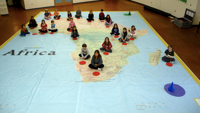
Students at are exploring Africa in a big way this week — with the world’s largest map of the continent.
The map, measuring 35-feet-by-26-feet, is designed as a geo-game board to introduce students to the power of maps and the diverse geography of Africa. It is at Middle School from Oct. 3 to 14 as part of National Geographic’s Giant Traveling Maps program, organized by National Geographic Live, the public programming division of the National Geographic Society. On Oct. 6, the map will be part of the sixth Grade Family Geography Night.
The map’s brightly colored, smooth vinyl surface accurately illustrates Africa’s oceans, seas, rivers, mountains, countries and capitals. Designed for grades K-8, the map comes with a trunk full of accessories, including interactive activities and props and photo cards that teach students about the physical characteristics of the continent as well as its rich history, marvelous wildlife, and varied cultures. Working in teams, students will mark the equator with ropes to learn about climate and latitude. A relay race will help them learn all the countries; scavenger hunts and safaris will introduce them to the continent’s famed wildlife and varied environments.
Find out what's happening in North Andoverfor free with the latest updates from Patch.
“Children have a whole new perspective on Africa after they’ve walked on this map,” said Dan Beaupré, director of education partnerships for National Geographic Live. “The hands- and feet-on experience brings the geography of Africa to life in a meaningful way and helps the students understand the connections between people and places.”
The map was first featured as a standard pull-out map in the September 2005 issue of National Geographic magazine, a special issue devoted entirely to Africa. National Geographic’s map division enlarged the map — the biggest map ever created by the Society — for educational tours through National Geographic Live.
Find out what's happening in North Andoverfor free with the latest updates from Patch.
Since the introduction of the original Africa map in 2006, the program has expanded to include maps of Asia, North America, South America, and the Pacific Ocean. Each map measures 26 feet by 35 feet and is loaned to schools and other hosts with an assortment of activities. In the 2011-2012 school year it is estimated more than 450,000 students will interact with one of these maps.
National Geographic’s Giant Traveling Maps also showcases My Wonderful World, a multiyear National Geographic-led campaign to improve geographic literacy and to help students become more informed global citizens. The campaign (mywonderfulworld.org) is designed to improve the geographic literacy of young people ages 8-17 by motivating parents and educators to make geography more available and accessible in school, at home and in the community.
To learn more about the Giant Traveling Map project, for borrowing information or to download map activities, visit www.nationalgeographic.com/giantmaps.
Get more local news delivered straight to your inbox. Sign up for free Patch newsletters and alerts.