Weather
2 Feet Of Snow Now 'Expected' For Twin Cities Metro: Minnesota Weather
The Twin Cities metro area appears to be at the epicenter of this potentially historic and dangerous snowstorm.


MINNEAPOLIS — Well, this one is gonna be a doozy. The National Weather Service says that 2 feet of snow is now "expected" from the winter snowstorm. The system is expected to come in two parts, one on Tuesday afternoon and a second on Wednesday afternoon.
UPDATE: Snowstorm Will Hit 'Category 5' In Twin Cities: MN Weather
"A major winter storm will bring significant travel impacts across the region. Most locations can expect to see at least a foot of snow by the time it ends Thursday night," the NWS said in its recently-issued winter storm warning for most of the Twin Cities metro area.
Find out what's happening in Minneapolisfor free with the latest updates from Patch.
"The worst conditions will be Wednesday evening through Thursday, as heavy snow combines with northeast wind gusts of 30 to 40 mph."
The Twin Cities metro area appears to be at the epicenter of this potentially historic and dangerous snowstorm.
Find out what's happening in Minneapolisfor free with the latest updates from Patch.
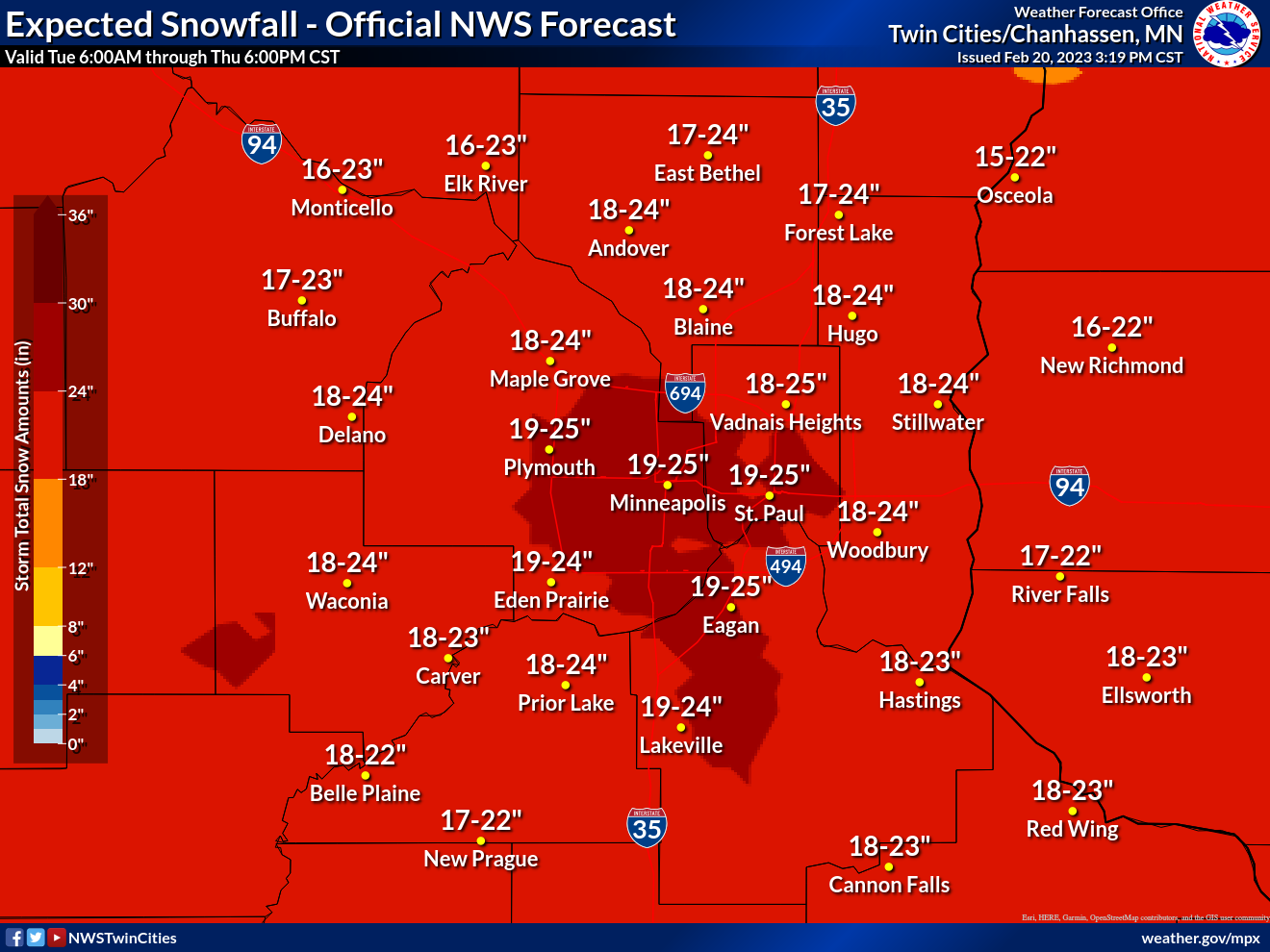
Here's a breakdown for expected snow totals in towns and suburbs across the metro.
Check out a look at the forecast for the entire state of Minnesota:

Here's the specific NWS forecast from the Minneapolis-St. Paul Airport:
Tuesday: Snow, mainly after 4pm. High near 21. West northwest wind 5 to 10 mph becoming southeast in the afternoon. Chance of precipitation is 80%. New snow accumulation of 1 to 2 inches possible.
Tuesday Night: Snow. Low around 17. East wind 10 to 15 mph. Chance of precipitation is 100%. New snow accumulation of 2 to 4 inches possible.
Wednesday: Snow likely, mainly after 1pm. Patchy blowing snow after 8am. Cloudy, with a high near 24. Blustery, with a northeast wind 15 to 25 mph, with gusts as high as 40 mph. Chance of precipitation is 70%. New snow accumulation of 1 to 3 inches possible.
Wednesday Night: Snow. The snow could be heavy at times. Widespread blowing snow, mainly after 7pm. Low around 13. Windy, with a northeast wind around 30 mph, with gusts as high as 45 mph. Chance of precipitation is 100%. New snow accumulation of 8 to 12 inches possible.
Thursday: Snow, mainly before 1pm. The snow could be heavy at times. Widespread blowing snow, mainly before 1pm. High near 17. Windy, with a northeast wind 20 to 30 mph, with gusts as high as 40 mph. Chance of precipitation is 100%. New snow accumulation of 5 to 9 inches possible.
Thursday Night: A 50 percent chance of snow before 7pm. Areas of blowing snow before 8pm. Mostly cloudy, with a low around -7. Blustery, with a northwest wind 15 to 20 mph decreasing to 5 to 10 mph after midnight. Winds could gust as high as 30 mph.
Friday: Partly sunny, with a high near 12. Northwest wind around 5 mph becoming south in the afternoon.
Friday Night: A chance of snow between 7pm and 1am. Mostly cloudy, with a steady temperature around 11. South southeast wind around 10 mph. Chance of precipitation is 30%.
Saturday: Mostly sunny, with a high near 26. West southwest wind 10 to 15 mph.
Saturday Night: Mostly clear, with a low around 8. West wind 10 to 15 mph.
Sunday: Sunny, with a high near 27. West wind around 10 mph.
Sunday Night: Mostly clear, with a low around 15. South southeast wind around 10 mph.
Monday: A 30 percent chance of snow. Partly sunny, with a high near 36. South southeast wind 10 to 15 mph becoming east in the afternoon.
Get more local news delivered straight to your inbox. Sign up for free Patch newsletters and alerts.


