Weather
7-12 Inches Of Snow Forecasted In Weekend System: MN Weather
Round one of the spring snow in Minnesota is over. Round two is expected to be even bigger.


TWIN CITIES, MN — Round one of spring snow is over. Round two is expected to be even bigger.
UPDATE: Timing, Amounts For Sunday Snowstorm: MN Weather
Minnesotans saw somewhere between 3.5 inches and 6 inches of snow from Thursday's system. But the snowstorm set to arrive this weekend could drop up to 12 inches of snow, accompanied by strong winds, according to the latest forecast from the National Weather Service.
Find out what's happening in Minneapolisfor free with the latest updates from Patch.
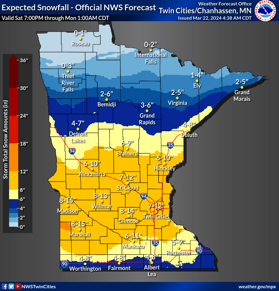
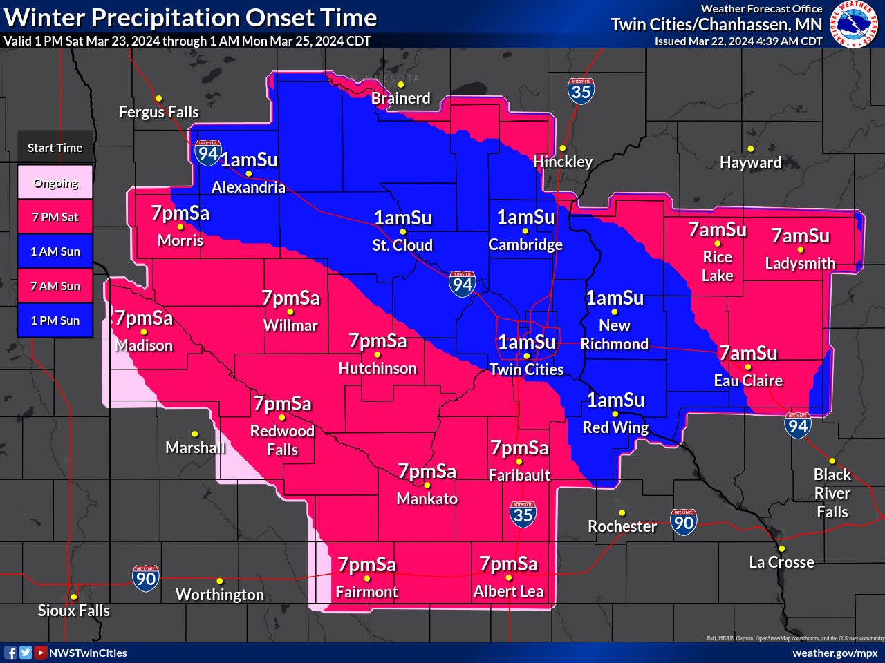
The next system is expected to arrive around 1 a.m. Sunday for most in the Twin Cities metro area. Parts southwest will see it begin a bit earlier.
A winter storm watch will be in effect from Sunday morning through Monday morning.
Find out what's happening in Minneapolisfor free with the latest updates from Patch.
"Travel could be very difficult to impossible. Widespread blowing snow could significantly reduce visibility," the NWS said. "The hazardous conditions could impact the morning or evening commute."
Rain could mix in with snow at times, affecting snowfall totals.

Here's the specific NWS forecast from the Minneapolis-St. Paul Airport:
Friday: A 40 percent chance of snow, mainly before 9am. Mostly cloudy, with a high near 36. North wind 5 to 15 mph.
Friday Night: Mostly clear, with a low around 17. North wind 5 to 10 mph.
Saturday: Increasing clouds, with a high near 34. North northeast wind around 5 mph becoming east southeast in the afternoon.
Saturday Night: Snow likely, mainly after 1am. Cloudy, with a low around 26. East southeast wind 5 to 10 mph. Chance of precipitation is 70%. New snow accumulation of less than one inch possible.
Sunday: Snow before 4pm, then snow, possibly mixed with rain. The snow could be heavy at times. Widespread blowing snow, mainly after 1pm. High near 36. Breezy, with an east southeast wind 15 to 20 mph increasing to 20 to 25 mph in the afternoon. Winds could gust as high as 35 mph. Chance of precipitation is 100%. New snow accumulation of 3 to 7 inches possible.
Sunday Night: Snow, possibly mixed with rain. The snow could be heavy at times. Widespread blowing snow, mainly before 9pm. Low around 31. Windy, with an east wind 25 to 30 mph, with gusts as high as 40 mph. Chance of precipitation is 100%. New snow accumulation of 4 to 8 inches possible.
Monday: Rain, possibly mixed with snow, becoming all rain after 4pm. The snow could be heavy at times. Patchy blowing snow before 11am. High near 41. Breezy, with an east northeast wind 15 to 20 mph, with gusts as high as 35 mph. Chance of precipitation is 90%. New precipitation amounts between a half and three quarters of an inch possible.
Monday Night: Rain before 8pm, then rain and snow. Low around 25. Northeast wind around 15 mph becoming north northwest after midnight. Chance of precipitation is 80%.
Tuesday: A 40 percent chance of snow. Patchy blowing snow before 7am. Mostly cloudy, with a steady temperature around 30. Blustery, with a west northwest wind 15 to 20 mph, with gusts as high as 30 mph.
Tuesday Night: A 20 percent chance of snow before 1am. Mostly cloudy, with a low around 15. Blustery, with a west northwest wind 15 to 20 mph, with gusts as high as 30 mph.
Wednesday: Mostly sunny, with a high near 32. West wind around 15 mph.
Wednesday Night: Partly cloudy, with a low around 16. West wind around 10 mph.
Thursday: Mostly sunny, with a high near 43. West southwest wind 5 to 10 mph.
Get more local news delivered straight to your inbox. Sign up for free Patch newsletters and alerts.


