Weather
Another Round Of Snow Arrives Saturday: MN Weather
The incoming storm will likely vault the current season into the top 10 snowiest winters in Twin Cities' recorded history.


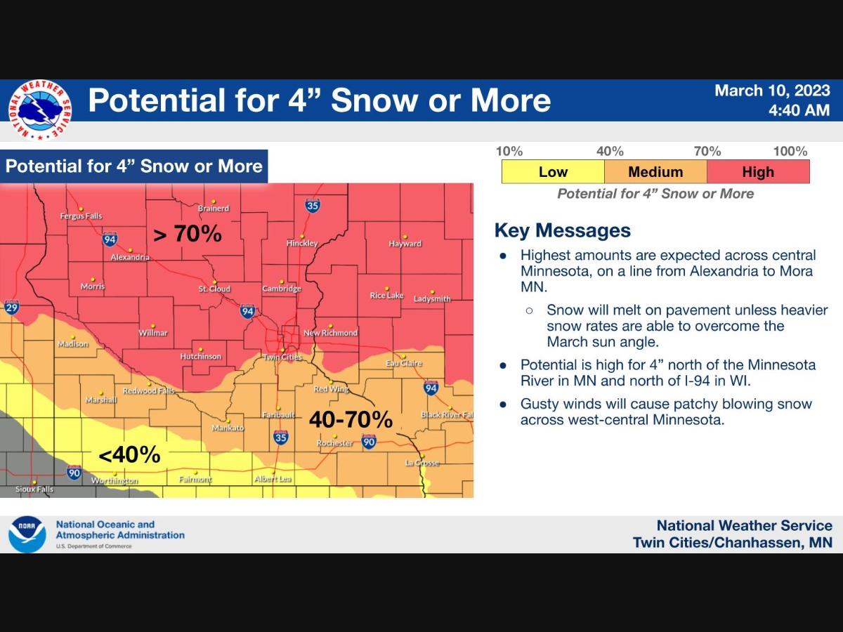
TWIN CITIES, MN — The National Weather Service issued a winter storm watch for much of central Minnesota as another round of snow arrives Saturday morning. Much of the Twin Cities metro area will likely see 4 inches of new snow or more this weekend.
The upcoming storm will likely vault the current season into the top 10 snowiest winters in Twin Cities' recorded history.
Check out the seasonal snow totals, courtesy of the NWS:
Find out what's happening in Minneapolisfor free with the latest updates from Patch.
- Minneapolis-St. Paul Airport Office: 78.1 inches (11th most snowy)
- Chanhassen NWS Office: 87.9 inches
- St. Cloud Office: 70.4 inches (7th most snowy)
- Eau Claire Office: 65 inches (16th most snowy)
Here's the specific NWS forecast from the Minneapolis-St. Paul Airport:
Friday: A 30 percent chance of snow, mainly before 8am. Cloudy, with a high near 33. Northeast wind 5 to 10 mph.
Find out what's happening in Minneapolisfor free with the latest updates from Patch.
Friday Night: Cloudy, with a low around 26. Northeast wind 5 to 10 mph becoming east southeast after midnight.
Saturday: Snow, mainly after 7am. The snow could be heavy at times. Patchy blowing snow between 1pm and 2pm. High near 32. East southeast wind around 15 mph, with gusts as high as 25 mph. Chance of precipitation is 90%. New snow accumulation of 3 to 5 inches possible.
Saturday Night: Snow, mainly before 1am. The snow could be heavy at times. Low around 26. Southeast wind 10 to 15 mph becoming south southwest after midnight. Chance of precipitation is 90%. New snow accumulation of 1 to 2 inches possible.
Sunday: A 40 percent chance of snow, mainly before 1pm. Mostly cloudy, with a high near 33. Southwest wind 10 to 15 mph becoming northwest in the afternoon.
Sunday Night: A 20 percent chance of snow before 7pm. Patchy blowing snow before 3am. Mostly cloudy, with a low around 19. Blustery, with a north northwest wind 15 to 20 mph, with gusts as high as 30 mph.
Monday: Partly sunny, with a high near 29. North northwest wind 10 to 15 mph.
Monday Night: Partly cloudy, with a low around 11. North northwest wind 5 to 10 mph becoming southwest after midnight.
Tuesday: Mostly sunny, with a high near 32. South southeast wind 5 to 10 mph.
Tuesday Night: A 20 percent chance of snow after 1am. Mostly cloudy, with a low around 27. South southeast wind around 15 mph.
Wednesday: A slight chance of rain and snow. Mostly cloudy, with a high near 42. South southeast wind around 15 mph, with gusts as high as 25 mph. Chance of precipitation is 20%.
Wednesday Night: A 20 percent chance of rain. Mostly cloudy, with a low around 31. South wind 10 to 15 mph becoming west northwest after midnight.
Thursday: A chance of rain and snow. Mostly cloudy, with a high near 40. Northwest wind 10 to 15 mph. Chance of precipitation is 30%.
Get more local news delivered straight to your inbox. Sign up for free Patch newsletters and alerts.