Weather
Blizzard Warnings Expand, Snow Estimates Rise In MN As 'Historic' Winter Storm Arrives
Gov. Tim Walz ordered the MN National Guard to be on standby as the storm could drop close to 2 feet of snow on parts of the state.

Heavy snow was falling across Minnesota overnight Saturday into Sunday including in the Twin Cities, and forecasters are predicting it could be the biggest one of the season.
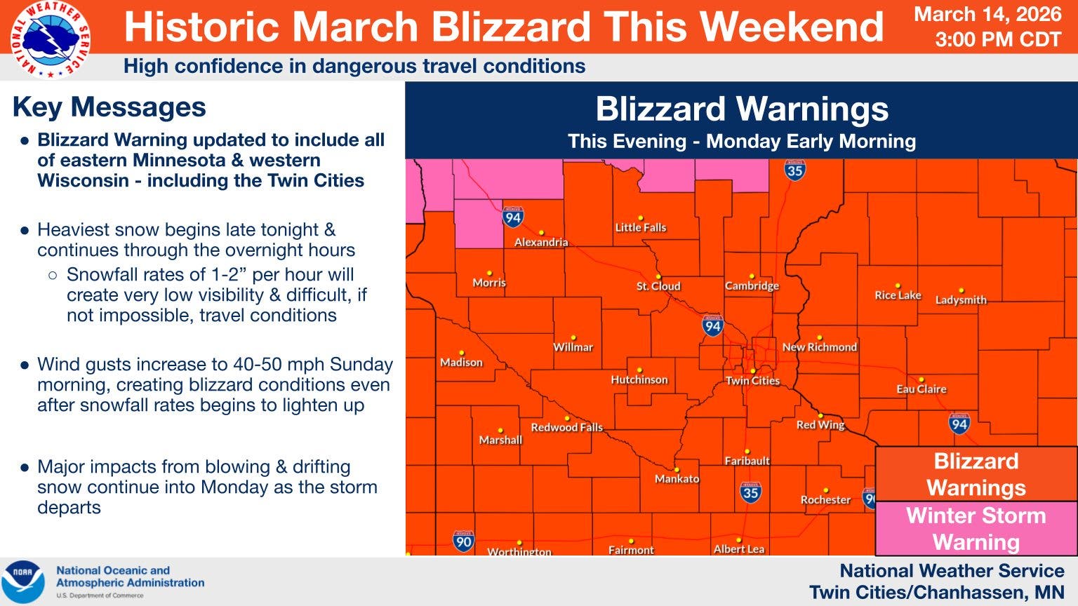
Blizzard warnings that go into effect at 10 a.m. Sunday were expanded to include all of eastern Minnesota along with central and southern portions of the state through 4 a.m. Monday for the storm, which the National Weather Service was calling a historic March blizzard.
A winter storm warning took effect at 4 p.m. Saturday for cities including Minneapolis, St. Paul, Shakopee, Stillwater, St. Cloud and Red Wing. Snow had started to fall as of 7 p.m. Saturday and roads were getting slippery. The weather service said travel will be nearly impossible by early Sunday and forecasters were urging people to stay off the roads.
Find out what's happening in Minneapolisfor free with the latest updates from Patch.
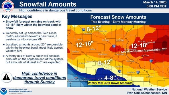
As much as a foot of snow and up to 18 inches is predicted for a wide swath of the area with snowfall amounts of 1 to 3 inches per hour anticipated by Sunday morning, the forecasters said.
There could even be some thundersnow, the forecasters said.
Find out what's happening in Minneapolisfor free with the latest updates from Patch.
Gov. Tim Walz authorized the National Guard to provide support through this weekend’s snowstorm before the storm's arrival.
"I’m grateful to our Guard members for stepping up to help their neighbors," Walz wrote on X. "Never trust spring weather in March."
The National Weather Service did a deep dive into the forecast in a Facebook Live event on the Twin Cities page.
"This is going to be a really impactful storm," one of the forecasters said.
The forecasters said a broad area of 12 to 18 inches is expected across central Minnesota and western Wisconsin, with locally higher amounts possible near the Twin Cities metro. Some sleet may mix in across the far south metro late Saturday.
A narrow swath within that band could drop 2 feet in parts of far east-central Minnesota and west-central Wisconsin, forecasters said.
The forecasters said the good news is the snow should not stick around for a long period because the weather should warm up sooner because spring is near.
In southern portions of the state, a wintry mix of rain,
freezing rain, and sleet is expected to creep into the area. A half-inch of sleet and a tenth of an inch of ice are expected from New Ulm to Red Wing and south. The wintry mix will
turn to all snow Sunday morning.
The second concern is increasing winds on Sunday, the National Weather Service wrote.
"Even though the snow will be tapering off gradually throughout Sunday, northwest winds will increase to 30 to 40 mph. Some gusts of 50 to 55 mph are possible," forecasters said.
The combination of falling snow, blowing snow and gusty
winds will reduce visibility and create blizzard conditions late
Sunday morning through Sunday evening across western and southern Minnesota.
Travel conditions were expected to be nearly impossible as of early Sunday.
"If you must travel, keep an extra flashlight, food, and water in your vehicle in case of an emergency," forecasters said.
Minnesotans can check road conditions by calling 511 or visiting 511mn.org.
Ahead of the storm, a significant number of flights have been cancelled at Minneapolis-St. Paul International Airport Saturday evening into Sunday, according to flight tracking website FlightAware.com. Airlines are advising travelers to plan ahead and rebook their flights.
Delta Airlines on Friday said passengers traveling out of MSP and several other Midwest airports can rebook their flights for no fee, provided the rebooked travel occurs on or before March 22.
Here's a look at the detailed National Weather Service forecast for the Twin Cities:
Sunday: Snow. The snow could be heavy at times. Widespread blowing snow, mainly between 11 a.m. and 1 p.m. High near 31. Windy, with a north wind 20 to 30 mph, with gusts as high as 45 mph. Chance of precipitation is 100 percent. New snow accumulation of 4 to 8 inches possible.
Sunday Night: Snow, mainly before midnight. Areas of blowing snow. Low around 7. Windy, with a north northwest wind 25 to 30 mph, with gusts as high as 45 mph. Chance of precipitation is 90 percent. New snow accumulation of less than a half inch possible.
Monday: Patchy blowing snow. Cloudy, then gradually becoming mostly sunny, with a high near 17. Blustery, with a north northwest wind around 20 mph, with gusts as high as 35 mph.
Monday Night: Mostly clear, with a low around -4. Northwest wind 5 to 15 mph.
Tuesday: A 30 percent chance of snow after 1 p.m. Increasing clouds, with a high near 25. West wind 5 to 10 mph becoming south southeast in the afternoon.
Get more local news delivered straight to your inbox. Sign up for free Patch newsletters and alerts.


