Weather
NWS Warns Of 'Life-Threatening' Snowstorm: MN Weather
Tree damage, power outages, and whiteout conditions are likely in the winter storm that will make travel impossible at times in Minnesota.


TWIN CITIES, MN — Minnesota drivers who head out on the roads this week will be facing "life-threatening conditions," the National Weather Service warned. Snow, extremely cold temperatures, and blizzard-causing winds could make travel impossible at times.
Weather officials say Christmas week travel plans should be altered now to ensure safety. If you must drive, consider that Wednesday and Thursday will be the absolute worst days to travel, and plan your trip accordingly.
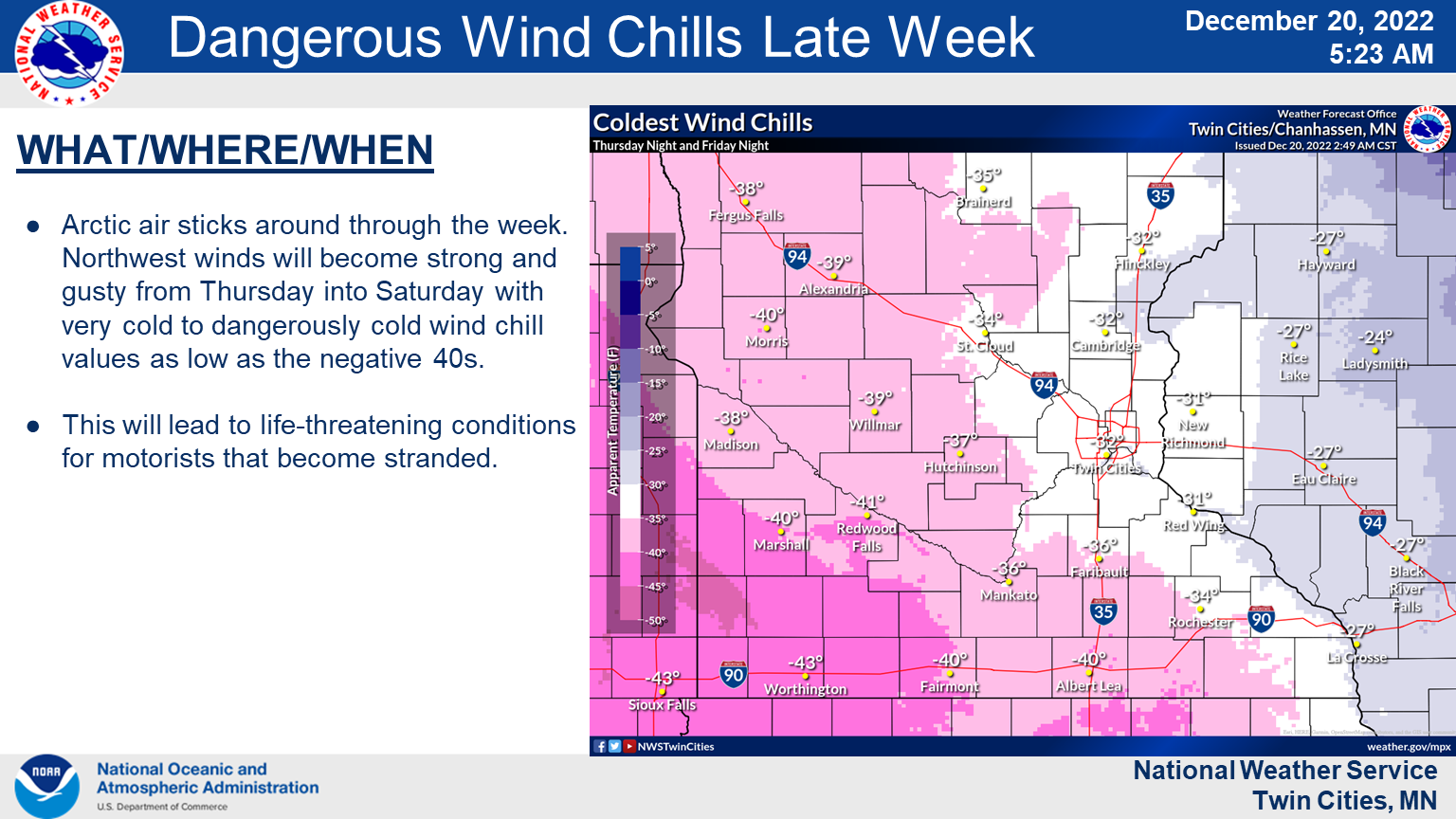
"Strong gusty winds Thursday into Saturday, combined with cold air temperatures, will result in very cold to dangerous wind chills as low as the negative 40s."
Find out what's happening in Minneapolisfor free with the latest updates from Patch.
The whiteout conditions and heavy snow are likely to cause power outages and tree damage across the region.
Find out what's happening in Minneapolisfor free with the latest updates from Patch.
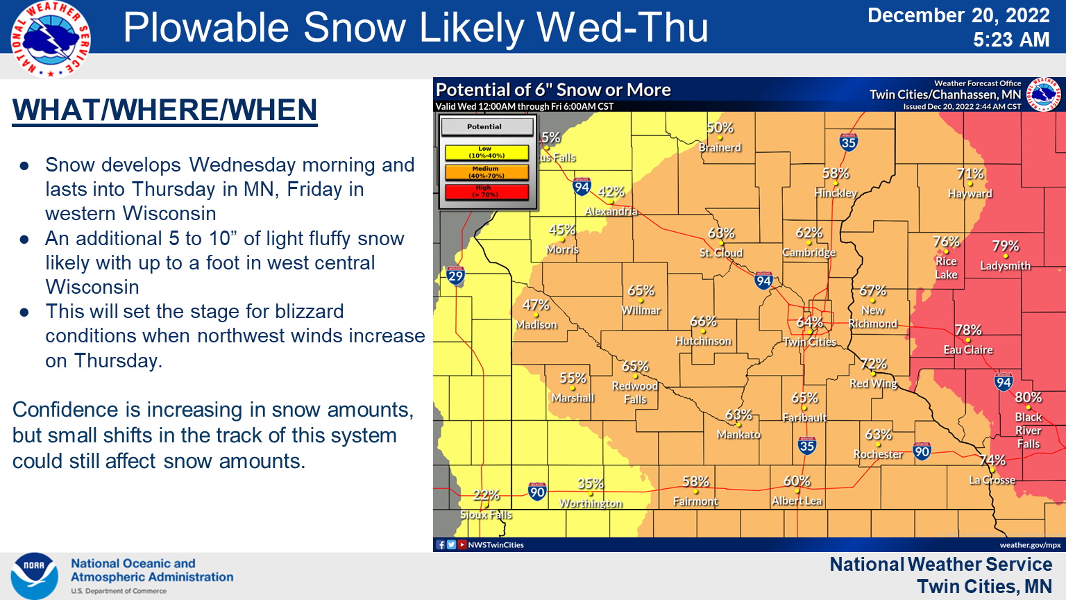
The Twin Cities metro could see up to 6 inches of snow or more between Wednesday and Thursday.
Here are the high winds that Minnesotans can expect this week:

"Snow will overspread the region Wednesday and bring several inches of fluffy accumulation through early Thursday," the NWS said in its winter storm watch issued for the counties of Mille Lacs, Kanabec, Isanti, Chisago, Hennepin, Anoka, Ramsey, Washington, and Dakota.
"Winds will be relatively light Wednesday and Wednesday evening. Then, strong northwest winds gusting as high as 55 mph and dangerously cold air will surge in Thursday through Saturday morning. Whiteout conditions are expected during that time with travel becoming very difficult or impossible."
Here's the full NWS forecast from the Minneapolis-St. Paul Airport:
Tuesday: Sunny and cold, with a high near 5. Wind chill values as low as -20. West northwest wind around 10 mph.
Tuesday Night: A 30 percent chance of snow after 5am. Increasing clouds, with a low around -7. Wind chill values as low as -18. West northwest wind 5 to 10 mph becoming light and variable after midnight.
Wednesday: Snow, mainly after 8am. High near 8. Wind chill values as low as -17. East wind 5 to 10 mph. Chance of precipitation is 90%. New snow accumulation of 1 to 3 inches possible.
Wednesday Night: Snow, mainly before midnight. Low around -1. Wind chill values as low as -14. East wind 10 to 15 mph becoming northwest after midnight. Chance of precipitation is 90%. New snow accumulation of 2 to 4 inches possible.
Thursday: A 40 percent chance of snow. Widespread blowing snow, mainly after 5pm. Cloudy and cold, with a temperature falling to around -1 by 9am. Blustery, with a northwest wind 15 to 25 mph, with gusts as high as 35 mph.
Thursday Night: A 40 percent chance of snow. Widespread blowing snow, mainly before 8pm. Mostly cloudy, with a low around -7. Windy, with a northwest wind 25 to 30 mph, with gusts as high as 40 mph.
Friday: A 20 percent chance of snow before noon. Widespread blowing snow. Mostly cloudy and cold, with a high near 2. Windy, with a northwest wind 25 to 30 mph, with gusts as high as 40 mph.
Friday Night: Widespread blowing snow, mainly before 8pm. Mostly cloudy, with a low around -4. Blustery, with a northwest wind 20 to 25 mph, with gusts as high as 35 mph.
Saturday: Areas of blowing snow. Mostly sunny, with a high near 6. Blustery, with a northwest wind 20 to 25 mph, with gusts as high as 35 mph.
Saturday Night: Partly cloudy, with a low around -6. West northwest wind 10 to 15 mph, with gusts as high as 25 mph.
Christmas Day: Mostly sunny, with a high near 9. West wind around 10 mph.
Sunday Night: A 20 percent chance of snow. Mostly cloudy, with a low around 0. South southwest wind around 10 mph.
Monday: Mostly sunny, with a high near 14. West northwest wind around 10 mph.
Get more local news delivered straight to your inbox. Sign up for free Patch newsletters and alerts.