Weather
Severe Weather Could Bring Hail, Tornadoes: MN Weather
Severe weather is expected in the Twin Cities metro area and beyond starting early Wednesday.


MINNEAPOLIS — Severe weather is expected in the Twin Cities metro area and beyond starting early Wednesday.
"Scattered supercells could develop by early Wednesday evening from western to central MN. These storms would then move east-southeast growing upscale into small clusters," the Naitonal Weather Service said.
"Very large hail, damaging winds, tornadoes, and heavy rain would all be possible with the supercells. Once the storms form into small clusters, damaging winds would become the main threat while hail, tornadoes, and heavy rain will still be possible."
Find out what's happening in Minneapolisfor free with the latest updates from Patch.
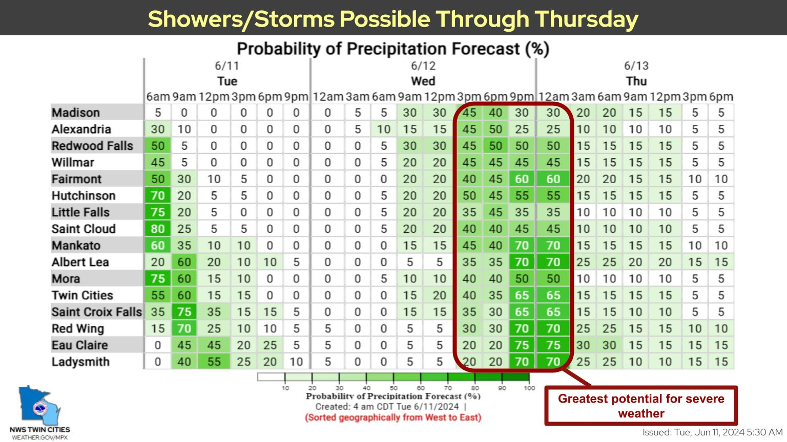
Here's the specific NWS forecast from the Minneapolis-St. Paul Airport:
Tuesday: Isolated showers before 1pm. Mostly cloudy, then gradually becoming sunny, with a high near 81. West wind around 15 mph. Chance of precipitation is 20%.
Find out what's happening in Minneapolisfor free with the latest updates from Patch.
Tuesday Night: Mostly clear, with a low around 62. West northwest wind 5 to 10 mph becoming south southwest after midnight.
Wednesday: A slight chance of showers, then a chance of showers and thunderstorms after 10am. Mostly sunny, with a high near 86. South wind 5 to 15 mph, with gusts as high as 25 mph. Chance of precipitation is 40%.
Wednesday Night: Showers and thunderstorms likely before 4am, then a slight chance of showers. Partly cloudy, with a low around 66. South southwest wind 10 to 15 mph. Chance of precipitation is 60%. New rainfall amounts between a quarter and half of an inch possible.
Thursday: Mostly sunny, with a high near 82. West northwest wind 10 to 15 mph.
Thursday Night: Clear, with a low around 60. Northwest wind 5 to 15 mph.
Friday: Sunny, with a high near 81. North wind around 5 mph.
Friday Night: A 30 percent chance of showers and thunderstorms after 1am. Mostly cloudy, with a low around 62. Southeast wind 5 to 10 mph.
Saturday: Showers likely and possibly a thunderstorm. Mostly cloudy, with a high near 78. Southeast wind 10 to 15 mph, with gusts as high as 30 mph. Chance of precipitation is 60%.
Saturday Night: Showers likely and possibly a thunderstorm. Mostly cloudy, with a low around 69. South southeast wind 10 to 15 mph, with gusts as high as 25 mph. Chance of precipitation is 70%.
Sunday: A 40 percent chance of showers and thunderstorms. Mostly sunny, with a high near 90. South southwest wind 10 to 15 mph.
Sunday Night: A 40 percent chance of showers and thunderstorms. Partly cloudy, with a low around 70. South southwest wind around 10 mph.
Monday: A 40 percent chance of showers and thunderstorms. Partly sunny, with a high near 86. South wind 10 to 15 mph.
Get more local news delivered straight to your inbox. Sign up for free Patch newsletters and alerts.