Weather
Subzero Temps, More Snow This Week: MN Weather
Winter has finally arrived in Minnesota. Here's what to expect this week.


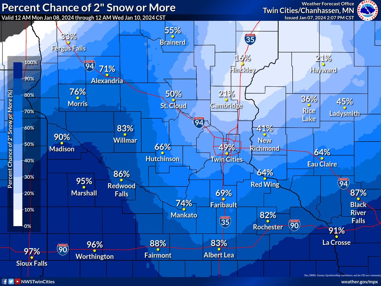
MINNEAPOLIS — Another modest snowstorm is on the docket for much of Minnesota starting Monday. The Twin Cities metro area should expect at least around 1 inch of new snow accumulation and more further north.
"Areas of western and southern Minnesota have the best chance to see accumulating snow of greater than 2 inches," the National Weather Service said.

Meanwhile, temperatures will continue to drop this week, falling into the subzero range. The low on Saturday night is 1 degree below zero, and the high is 8 degrees.
Find out what's happening in Minneapolisfor free with the latest updates from Patch.
Here's the specific NWS forecast from the Minneapolis-St. Paul Airport:
Monday: Snow, mainly before 1pm. High near 32. East wind 5 to 10 mph. Chance of precipitation is 90%. New snow accumulation of less than a half inch possible.
Find out what's happening in Minneapolisfor free with the latest updates from Patch.
Monday Night: Snow, mainly after 10pm. Low around 28. East wind 5 to 10 mph becoming north northeast after midnight. Chance of precipitation is 90%. New snow accumulation of 1 to 2 inches possible.
Tuesday: A 40 percent chance of snow, mainly before noon. Cloudy, with a high near 33. Breezy, with a north wind 10 to 15 mph increasing to 15 to 20 mph in the afternoon. Winds could gust as high as 30 mph.
Tuesday Night: Mostly cloudy, with a low around 19. Blustery, with a northwest wind 15 to 20 mph decreasing to 5 to 10 mph after midnight. Winds could gust as high as 30 mph.
Wednesday: A 20 percent chance of snow after noon. Mostly cloudy, with a high near 28. West northwest wind 5 to 10 mph becoming south southeast in the afternoon.
Wednesday Night: A 40 percent chance of snow. Mostly cloudy, with a low around 17. Southeast wind 5 to 10 mph becoming west after midnight.
Thursday: A 20 percent chance of snow. Mostly cloudy, with a temperature falling to around 18 by 5pm. West northwest wind 10 to 15 mph.
Thursday Night: Mostly cloudy, with a low around 7. West northwest wind 10 to 15 mph.
Friday: A 20 percent chance of snow after noon. Mostly cloudy, with a high near 16. North wind 10 to 15 mph.
Friday Night: A 30 percent chance of snow. Mostly cloudy, with a low around 4. North wind around 15 mph.
Saturday: A 30 percent chance of snow. Mostly cloudy, with a high near 13. North northwest wind around 15 mph.
Saturday Night: A 20 percent chance of snow. Mostly cloudy, with a low around -1. West northwest wind around 15 mph.
Sunday: Partly sunny, with a high near 8. West northwest wind 10 to 15 mph.
Get more local news delivered straight to your inbox. Sign up for free Patch newsletters and alerts.