Weather
-30 Wind Chill, Flash Freezing Roads Wednesday: Minnesota Weather
The Arctic front will bring "dangerous" wind chills into Minnesota this week.


TWIN CITIES, MN — The National Weather Service has issued wind chill warnings for much of central Minnesota, including the Minneapolis-St. Paul metro area. A winter weather advisory has been issued as well, as the Twin Cities will see some light snow and "flash freezing" on the roads and other surfaces.
"Plan on slippery road conditions," says the NWS. "The hazardous conditions could impact the morning or evening commute. The dangerously cold wind chills could cause frostbite on exposed skin in as little as 10 minutes."
Wind chills may fall to 30 degrees below zero Wednesday night.
Find out what's happening in Southwest Minneapolisfor free with the latest updates from Patch.
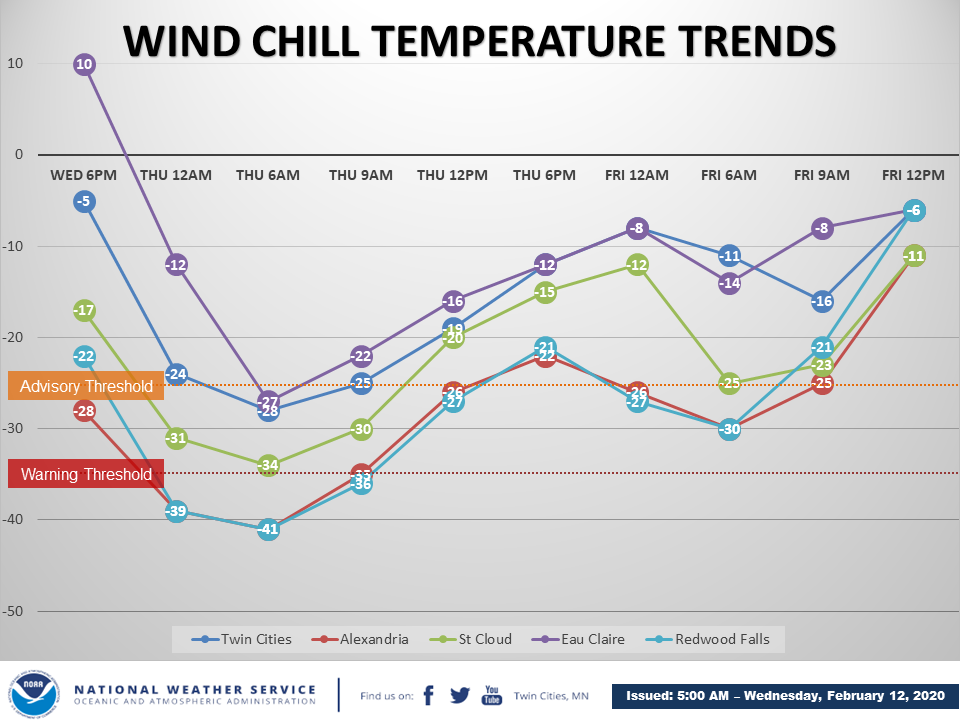
Far western Minnesota will see blizzard conditions at times.

Here's the NWS forecast for the Twin Cities:
Find out what's happening in Southwest Minneapolisfor free with the latest updates from Patch.
Wednesday: Snow, mainly before 5 p.m. Patchy blowing snow after 5 p.m. Temperature falling to around 16 by 5 p.m. Blustery, with a west southwest wind 10 to 15 mph becoming north northwest 15 to 20 mph in the afternoon. Winds could gust as high as 30 mph. Chance of precipitation is 90 percent. Total daytime snow accumulation of less than a half inch possible.
Wednesday Night: Patchy blowing snow before 7 p.m. Cloudy, then gradually becoming partly cloudy, with a low around -10. Wind chill values as low as -29. Blustery, with a north northwest wind 10 to 20 mph, with gusts as high as 30 mph.
Thursday: Sunny and cold, with a high near 1. Wind chill values as low as -28. West northwest wind 5 to 10 mph.
Thursday Night: Mostly clear, with a low around -12. West wind around 5 mph becoming calm in the evening.
Friday: Sunny, with a high near 16. South wind 5 to 10 mph increasing to 10 to 15 mph in the afternoon. Winds could gust as high as 25 mph.
Friday Night: A 20 percent chance of snow after midnight. Mostly cloudy, with a temperature rising to around 22 by 4 a.m. South wind 10 to 15 mph, with gusts as high as 25 mph.
Saturday: A 40 percent chance of snow, mainly before noon. Mostly cloudy, with a high near 35. South southwest wind around 10 mph becoming west in the afternoon.
Saturday Night: Mostly cloudy, with a low around 12. West wind 5 to 10 mph becoming light after midnight.
Sunday: Mostly sunny, with a high near 28. Calm wind becoming northeast around 5 mph in the afternoon.
Sunday Night: A 30 percent chance of snow after midnight. Mostly cloudy, with a low around 20. East wind around 5 mph becoming south after midnight.
Monday: A 50 percent chance of snow. Cloudy, with a high near 35. South southeast wind around 5 mph becoming northeast in the afternoon.
Monday Night: A 40 percent chance of snow. Cloudy, with a low around 19. North wind 5 to 10 mph.
Tuesday: A 20 percent chance of snow. Mostly cloudy, with a high near 27. North wind 5 to 10 mph becoming west northwest in the afternoon.
Get more local news delivered straight to your inbox. Sign up for free Patch newsletters and alerts.