Weather
All Signs Say That Cold Weather Will Continue: MN Forecast
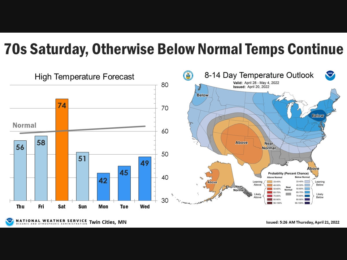
Saturday will be the only day in the forecast with above-normal temperatures, the National Weather Service said.

TWIN CITIES, MN — Save for one day, the cold, dreary weather will continue in Minnesota.
"Saturday will be the only day in the near future with above normal temperatures, otherwise expecting below normal temperatures to continue through next week," the National Weather Service said.
Here’s the full NWS forecast from the Minneapolis-St. Paul International Airport:
Find out what's happening in Southwest Minneapolisfor free with the latest updates from Patch.
Friday: Rain likely, with thunderstorms also possible after 2pm. Increasing clouds, with a high near 58. Breezy, with an east southeast wind 15 to 20 mph, with gusts as high as 35 mph. Chance of precipitation is 70%. New rainfall amounts of less than a tenth of an inch, except higher amounts possible in thunderstorms.
Friday Night: Rain likely and possibly a thunderstorm before 2am, then a chance of rain and thunderstorms after 2am. Some storms could be severe, with large hail. Mostly cloudy, with a temperature rising to around 59 by 4am. Breezy, with an east southeast wind 15 to 20 mph, with gusts as high as 30 mph. Chance of precipitation is 70%. New rainfall amounts between a tenth and quarter of an inch, except higher amounts possible in thunderstorms.
Find out what's happening in Southwest Minneapolisfor free with the latest updates from Patch.
Saturday: A chance of rain and thunderstorms, then showers and possibly a thunderstorm after 8am. Some storms could be severe, with large hail. High near 74. Breezy, with a south wind 15 to 25 mph, with gusts as high as 40 mph. Chance of precipitation is 80%. New rainfall amounts between a tenth and quarter of an inch, except higher amounts possible in thunderstorms.
Saturday Night: Showers and thunderstorms before 11pm, then a chance of showers between 11pm and 2am. Low around 47. Breezy, with a south wind 15 to 25 mph, with gusts as high as 40 mph. Chance of precipitation is 80%. New precipitation amounts of less than a tenth of an inch, except higher amounts possible in thunderstorms.
Sunday: Partly sunny, with a high near 51. Breezy, with a southwest wind 15 to 20 mph, with gusts as high as 35 mph.
Sunday Night: Mostly cloudy, with a low around 32. Breezy, with a west wind 15 to 20 mph, with gusts as high as 30 mph.
Monday: Partly sunny, with a high near 42. Breezy, with a west northwest wind 15 to 20 mph, with gusts as high as 25 mph.
Monday Night: Partly cloudy, with a low around 30. North northwest wind 10 to 15 mph.
Tuesday: Mostly sunny, with a high near 48. North northwest wind 10 to 15 mph.
Tuesday Night: Partly cloudy, with a low around 35. Northeast wind around 10 mph becoming east southeast after midnight.
Wednesday: A 20 percent chance of showers. Partly sunny, with a high near 55. Southeast wind 10 to 15 mph.
Get more local news delivered straight to your inbox. Sign up for free Patch newsletters and alerts.


