Weather
Minnesota Likely Won't Have A 'White Christmas' For 2021
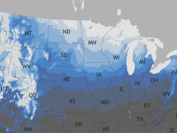
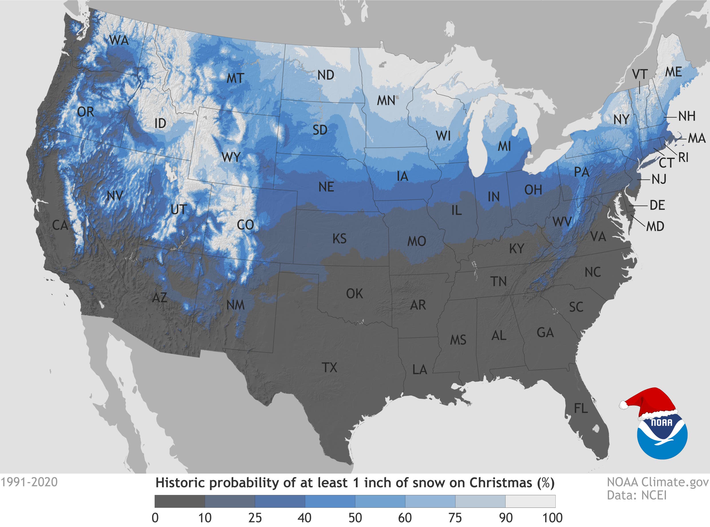
Historically, Minnesota has about a 70 percent chance of seeing a White Christmas, according to federal weather officials.

TWIN CITIES, MN — The National Weather Service defines a white Christmas aas having 1 inch or more of snow on the ground on Christmas morning. Despite Friday's snowstorm dropping over 2 feet of snow in some parts of the Minneapolis-St. Paul metro area, Minnesota's chances for a "white Christmas" are bleak.
Since the snowstorm, the state has seen historically-high temperatures. Wednesday's temperatures will blow past 50 degrees, accelerating the melting process.
A cold front will move in Thursday, dropping temperatures to below freezing. However, the forecasts through Christmas show no major snowstorms.
Find out what's happening in Southwest Minneapolisfor free with the latest updates from Patch.
Also read:
- Forecast Shows Thunderstorms, 50 Degrees. This Isn't Surprising
- NWS Shares Ominous Message On Wednesday Storm: MN Weather
Of course, Minnesota weather is known to change in a flash. But as it stands now, almost all of the snow currently on the ground will be gone on Christmas Day.
Find out what's happening in Southwest Minneapolisfor free with the latest updates from Patch.
Historically, Minnesota has about a 70 percent chance of seeing a White Christmas, according to the National Oceanic and Atmospheric Administration:
Here's the seven-day forecast for the Twin Cities metro are:
Wednesday: A chance of showers, with thunderstorms also possible after 5pm. Some storms could be severe, with damaging winds. Mostly cloudy, with a high near 61. South southeast wind around 10 mph, with gusts as high as 25 mph. Chance of precipitation is 40%.
Wednesday Night: Rain showers, snow showers, and freezing rain before 3am, then a slight chance of snow showers and freezing drizzle between 3am and 4am. Some thunder is also possible. Low around 23. Windy, with a south southeast wind 15 to 25 mph becoming west 25 to 35 mph in the evening. Winds could gust as high as 55 mph. Chance of precipitation is 100%. Little or no ice accumulation expected. Little or no snow accumulation expected.
Thursday: Mostly cloudy, then gradually becoming sunny, with a high near 26. Breezy, with a west wind 15 to 25 mph, with gusts as high as 45 mph.
Thursday Night: Increasing clouds, with a low around 17. West northwest wind 10 to 15 mph becoming west northwest 5 to 10 mph after midnight. Winds could gust as high as 25 mph.
Friday: A 20 percent chance of snow after noon. Mostly cloudy, with a high near 23. Northeast wind around 5 mph.
Friday Night: A 20 percent chance of snow. Mostly cloudy, with a low around 15. Northeast wind 5 to 10 mph becoming northwest after midnight.
Saturday: Partly sunny, with a high near 18. West northwest wind 5 to 10 mph.
Saturday Night: Partly cloudy, with a low around 9. West northwest wind around 5 mph becoming calm.
Sunday: Partly sunny, with a high near 30. South southeast wind 5 to 15 mph.
Sunday Night: Mostly cloudy, with a low around 19. South southeast wind around 10 mph becoming west southwest after midnight.
Monday: Mostly sunny, with a high near 25. West northwest wind 10 to 15 mph.
Monday Night: Partly cloudy, with a low around 11. West northwest wind 5 to 10 mph.
Tuesday: Partly sunny, with a high near 24. West northwest wind around 5 mph becoming south southwest in the morning.
Get more local news delivered straight to your inbox. Sign up for free Patch newsletters and alerts.


