Weather
8 Inches Of Snow, February Record Possible
This month could go down as the snowiest February of all time in Minnesota, thanks to another big winter storm arriving Tuesday.


TWIN CITIES, MN — This month has been so snowy, it could break the record for the snowiest February of all time (26.5 inches) in the Twin Cities metro. And it could happen in the next two days.
Find an updated forecast for Wednesday, Feb. 20 here.
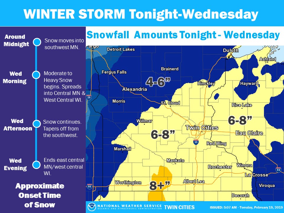
A winter storm warning has been issued for central Minnesota lasting through 6 p.m. Wednesday. The National Weather Service says total snowfall accumulations of 6 to 9 inches can be expected in the warning area, with up to 8 in the Twin Cities.
Find out what's happening in Southwest Minneapolisfor free with the latest updates from Patch.
The storm will drop heavy snow, especially during the Wednesday morning commute. The Wednesday evening commute may also be difficult.
"Accumulating snow will move into central MN and west central WI by Wednesday morning," says the NWS. "The heaviest accumulation will occur in the morning but snow will continue through the afternoon. This will lead to difficult travel conditions for the morning and possibly afternoon commutes."
Find out what's happening in Southwest Minneapolisfor free with the latest updates from Patch.
Snow will begin to fall late Tuesday evening.
Reminder: A winter storm warning means motorists should expect severe conditions that will make traveling hazardous, if not impossible. Be sure to keep a flashlight, food and water in your car in the case of an emergency.
Minnesota Department of Transportation snowplow operators will do their part to make highways safe and motorists should remember to:
- Stay alert for snowplows, which turn or exit frequently and often with little warning. They also may travel over centerlines or partially in traffic to further improve road conditions.
- Stay back at least 10 car lengths behind the plow. Don’t drive into a snow cloud.
- Slow down to a safe speed for current conditions.
- Turn on your headlights and wear your seat belt.
- Turn off the cruise control.
- Be patient and remember snowplows are working to improve road conditions for your trip.
- Don’t drive distracted.
This month has already set records for daily and monthly snowfall totals, and it could set more. The Twin Cities metro is just shy of breaking the all-time record for February snowfall.
Find the metro's all-time snowfall records for February, provided by the NWS, below:
- 26.5 inches (1962)
- 24.2 inches (1909)
- 23.7 inches (1967)
- 22.6 inches (2019) - could rise to no. 1 all-time this week
- 19.7 inches (2004, 1936)
- 18.4 inches (2014
- 17.8 inches (1893
- 17.3 inches (1989)
- 16.5 inches (2001)
So far this month, MSP has had 22.6" of snow. Between Wed and this weekend, we will likely send that number over 30". Going back to 1885 there have been 10 months with more than 30" of snow (1 in Nov and 3 each in Dec, Jan, and Mar) with the most recent being Dec 2010. #mnwx
— NWS Twin Cities (@NWSTwinCities) February 19, 2019
Heads up: even more snow is in the forecast for this weekend. Check out the Twin Cities, Minnesota weather forecast below:
Today: Areas of fog before 8 a.m. Otherwise, mostly sunny, with a high near 17. Wind chill values as low as -12. Calm wind becoming south southwest around 5 mph in the afternoon.
Tonight: Snow, mainly after 3 a.m. Temperature rising to around 17 by 4 a.m. East wind around 5 mph. Chance of precipitation is 80 percent. New snow accumulation of around an inch possible.
Wednesday: Snow, mainly before 4 p.m. The snow could be heavy at times. High near 27. East wind 5 to 10 mph becoming north in the afternoon. Chance of precipitation is 100 percent. New snow accumulation of 4 to 8 inches possible.
Wednesday Night: A 30 percent chance of snow, mainly before 9 p.m. Mostly cloudy, with a low around 15. West wind around 5 mph.
Thursday: Partly sunny, with a high near 25. West wind around 5 mph.
Thursday Night: Mostly cloudy, with a low around 11. West southwest wind around 5 mph becoming calm in the evening.
Friday: A 40 percent chance of snow after noon. Mostly cloudy, with a high near 27. East southeast wind around 5 mph.
Friday Night: Snow likely, mainly before midnight. Cloudy, with a low around 22. East southeast wind around 5 mph. Chance of precipitation is 60 percent.
Saturday: A 40 percent chance of snow. Cloudy, with a high near 33. Northeast wind 5 to 10 mph.
Saturday Night: Snow. Low around 24. North northeast wind 10 to 15 mph. Chance of precipitation is 80 percent.
Sunday: A 50 percent chance of snow. Cloudy, with a high near 28. North northwest wind around 15 mph.
Sunday Night: Mostly cloudy, with a low around 9. Northwest wind 5 to 15 mph.
Monday: Partly sunny, with a high near 23. Northwest wind around 5 mph becoming south in the afternoon.
Image via National Weather Service
Get more local news delivered straight to your inbox. Sign up for free Patch newsletters and alerts.