Weather
Minnesota Weather: Dangerously-Cold Temperatures Thursday
An Arctic blast is bringing brutal weather to Minnesota this week.


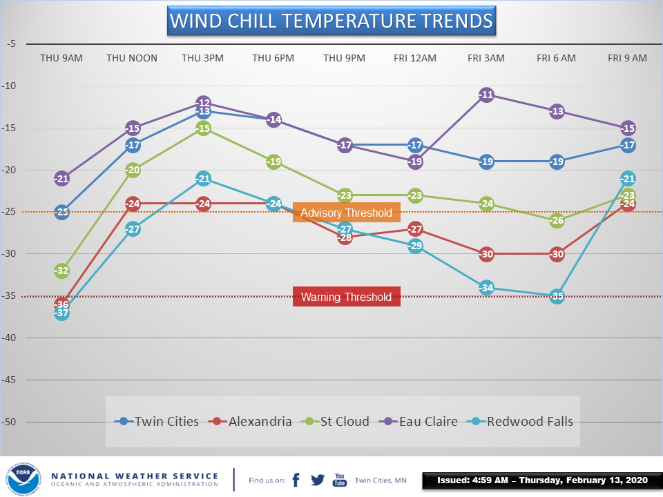
TWIN CITIES, MN — Wind chill advisories and warnings blanket Minnesota Thursday as the Arctic blast brings dangerously-cold temperatures. "Wind chill values of 35 to 45 degrees below zero over west central and south central Minnesota will continue into mid morning, with wind chills of 25 to 35 below zero expected through noon," says the National Weather Service.
"Farther east, wind chills of 25 to 35 below zero will continue through mid morning across east central Minnesota, southeast Minnesota, and west central Wisconsin. Wind chills could remain around 25 to 30 below zero through noon across southeast Minnesota and the southern Twin Cities metro."
Be sure to cover all exposed skin and limit time outdoors Thursday. The dangerously cold wind chills can cause frostbite on exposed skin in just 10 minutes. Always wear at least a heavy coat, mittens, and a hat. Cover your face as well.
Find out what's happening in Southwest Minneapolisfor free with the latest updates from Patch.
Here is the NWS weather forecast for the Twin Cities:
Thursday: Sunny and cold, with a high near 2. Wind chill values as low as -29. North northwest wind 5 to 15 mph.
Find out what's happening in Southwest Minneapolisfor free with the latest updates from Patch.
Thursday Night: Clear, with a low around -10. Wind chill values as low as -19. West wind around 5 mph becoming calm in the evening.
Friday: Sunny, with a high near 19. Wind chill values as low as -20. South wind 5 to 10 mph increasing to 10 to 15 mph in the afternoon.
Friday Night: A 20 percent chance of snow after midnight. Increasing clouds, with a temperature rising to around 23 by 5am. South wind 10 to 15 mph, with gusts as high as 30 mph.
Saturday: A 20 percent chance of snow before noon. Partly sunny, with a high near 35. West wind around 10 mph.
Saturday Night: Mostly cloudy, with a low around 12. West wind around 5 mph becoming calm after midnight.
Sunday: Partly sunny, with a high near 23. Calm wind becoming northeast around 5 mph.
Sunday Night: A 20 percent chance of snow after midnight. Mostly cloudy, with a low around 11. North wind around 5 mph becoming east southeast after midnight.
Monday: A 40 percent chance of snow. Cloudy, with a high near 27. Southeast wind around 5 mph becoming northeast in the afternoon.
Monday Night: A 40 percent chance of snow. Mostly cloudy, with a low around 10. East wind around 5 mph becoming north after midnight.
Tuesday: A 40 percent chance of snow. Partly sunny, with a high near 22. North northwest wind 5 to 10 mph.
Tuesday Night: A 20 percent chance of snow. Mostly cloudy, with a low around 6. West wind around 5 mph.
Wednesday: Partly sunny, with a high near 21. West wind around 5 mph.
Get more local news delivered straight to your inbox. Sign up for free Patch newsletters and alerts.