Weather
Twin Cities Under Storm Threat Wednesday — Worst of It Expected 1-6 PM
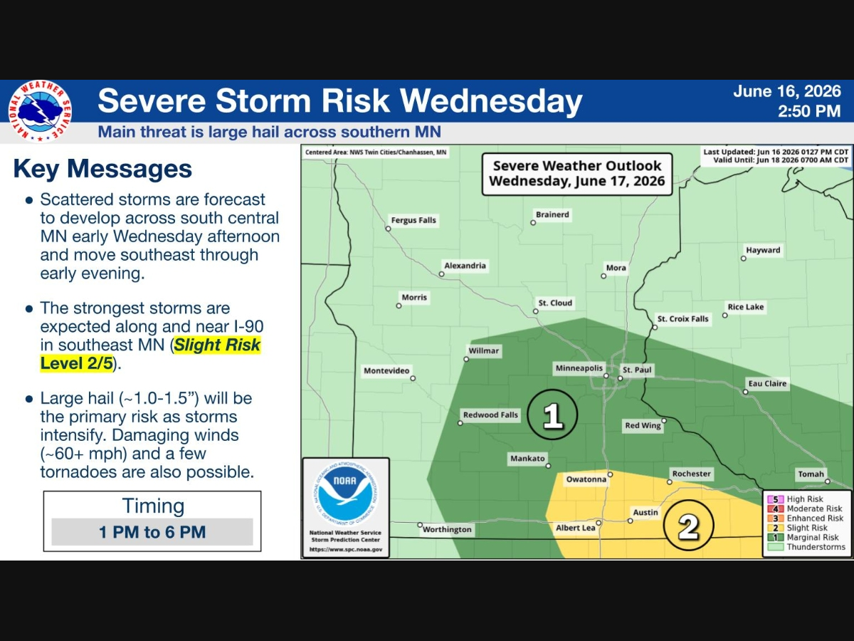
Hail up to 1.5 inches and damaging winds are the main threats as storms move through Wednesday afternoon.


TWIN CITIES, MN — A strong storm system will bring two rounds of rain to the Twin Cities on Wednesday, with the afternoon round carrying the potential for severe weather.
The National Weather Service has issued a Hazardous Weather Outlook for the metro.
Scattered showers and thunderstorms are expected to develop by early afternoon, with the most active period running from 1 to 6 p.m. The primary threat is large hail up to 1.5 inches in diameter, though damaging winds above 60 mph and a few tornadoes are also possible across southern Minnesota.
Find out what's happening in Southwest Minneapolisfor free with the latest updates from Patch.
The Twin Cities metro sits in a Marginal Risk zone, while areas along and south of I-90, including Albert Lea and Austin, face a Slight Risk.
Rain totals for the metro are forecast at around 0.39 inches Wednesday, with higher amounts possible in stronger storms. Conditions are expected to clear by Wednesday evening, with dry and mostly sunny weather returning Thursday.
Find out what's happening in Southwest Minneapolisfor free with the latest updates from Patch.
NWS forecasters note that SKYWARN storm spotter activation may be needed Wednesday afternoon.
Check out the full NWS forecast from the MSP Airport below:
Wednesday: A chance of showers and thunderstorms, then showers likely and possibly a thunderstorm after noon. Sunny, with a high near 69. Southeast wind 10 to 15 mph becoming west northwest in the afternoon. Chance of precipitation is 70%. New rainfall amounts between a tenth and quarter of an inch, except higher amounts possible in thunderstorms.
Wednesday Night: A 40 percent chance of showers and thunderstorms, mainly before 9pm. Mostly clear, with a low around 54. North northwest wind 10 to 15 mph.
Thursday: Mostly sunny, with a high near 70. Northwest wind 10 to 15 mph, with gusts as high as 25 mph.
Thursday Night: Mostly clear, with a low around 51. West northwest wind 5 to 15 mph.
Juneteenth: A 30 percent chance of showers and thunderstorms after 1pm. Sunny, with a high near 75. West wind 5 to 10 mph.
Friday Night: Mostly clear, with a low around 54. West northwest wind around 5 mph becoming calm in the evening.
Saturday: Sunny, with a high near 77. Calm wind becoming northwest around 5 mph in the afternoon.
Saturday Night: A 20 percent chance of showers after 1am. Partly cloudy, with a low around 57. North northwest wind around 5 mph becoming east after midnight.
Sunday: A 40 percent chance of showers and thunderstorms. Partly sunny, with a high near 74. East wind 5 to 10 mph.
Sunday Night: A 20 percent chance of showers and thunderstorms. Mostly cloudy, with a low around 56. East northeast wind 5 to 10 mph.
Monday: Mostly sunny, with a high near 76. East wind around 5 mph.
Monday Night: Partly cloudy, with a low around 57. North northeast wind around 5 mph becoming calm in the evening.
Tuesday: A 20 percent chance of showers and thunderstorms. Mostly sunny, with a high near 79. Calm wind becoming west around 5 mph in the afternoon.
Get more local news delivered straight to your inbox. Sign up for free Patch newsletters and alerts.


