Weather
Minnesota Weather: 'Dreadful' Evening Commute Continues
The snowstorm has arrived in Minnesota, and it's making the evening commute extremely difficult.


TWIN CITIES, MN — As the National Weather Service correctly predicted, Friday's evening commute in the Minneapolis-St. Paul metro area is "dreadful." Snow is falling at a rapid rate, and authorities have already responded to numerous crashes across central Minnesota, which is now under a winter storm warning.
Many roads are completely snow-covered. Plows are out, and cities are declaring snow emergencies.
The Minnesota Department of Transportation has expanded the no travel advisory in west central Minnesota. Motorists are advised not to travel on the following state and federal highways due to dangerous driving conditions:
Find out what's happening in Southwest Minneapolisfor free with the latest updates from Patch.
- Interstate 94 from Moorhead to Fergus Falls
- Highway 10 from Moorhead to Hawley
- Highway 336 from I-94 to Highway 10
- Highway 75 from Perley to Moorhead
- Highway 75 from Moorhead to Breckenridge
- Highway 9 from Barnesville to Breckenridge
- Highway 210, from Fergus Falls to Breckenridge
You can check current snowfall amounts here.
The snowstorm is making travel nearly impossible. People who must drive are advised to be ready for snow-covered and icy roads, strong winds, blowing snow and very cold temperatures.
Find out what's happening in Southwest Minneapolisfor free with the latest updates from Patch.
Well this doesn’t belong there. Homeowner says about an hour ago this car ended up in his front yard at 42nd and France in South Minneapolis. Proof of the slick roads. Glad car owner is ok. pic.twitter.com/yfIM1WqI9L
— Leah Beno (@LeahBenoFox9) January 17, 2020
Snow doesn’t cause crashes. Poor driving decisions cause crashes. Stay home! If you must travel, give yourself extra time, slow down, buckle up and drive to conditions. #MnWx pic.twitter.com/Dx8pOGCFdw
— MN State Patrol (@MnDPS_MSP) January 17, 2020
WC MN visibility is BAD - this video of a vehicle that slid of the road (Hwy336 just a few mile east of Moorhead - western Clay County). Several more vehicles are also off the road in the area. Be safe! pic.twitter.com/wueMymYHDJ
— Sgt. Jesse Grabow (@MSPPIO_NW) January 17, 2020
Here's a graphic displaying the timeline for the storm. The heaviest snow is within the brackets and the darkest blues.
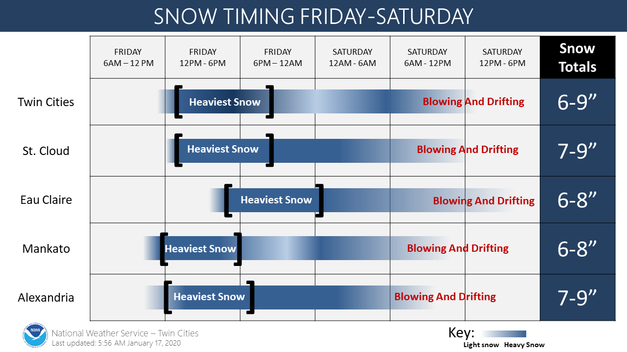
Here's the NWS forecast for the rest of the storm in the Twin Cities:
Friday: Snow. The snow could be heavy at times. Patchy blowing snow. High near 23. Southeast wind around 15 mph, with gusts as high as 30 mph. Chance of precipitation is 100 percent. Total daytime snow accumulation of 2 to 4 inches possible.
Friday Night: Snow before 10pm, then snow, possibly mixed with freezing drizzle between 10pm and 4am, then snow after 4am. The snow could be heavy at times. Patchy blowing snow before 10pm. Temperature rising to around 28 by 4 a.m. Breezy, with a southeast wind 15 to 20 mph decreasing to 5 to 10 mph after midnight. Winds could gust as high as 35 mph. Chance of precipitation is 100 percent. Little or no ice accumulation expected. New snow accumulation of 3 to 5 inches possible.
Saturday: Snow, mainly before 10 a.m. Patchy blowing snow after 11 a.m. Temperature falling to around 9 by 5pm. Wind chill values as low as -11. Blustery, with a southwest wind 5 to 10 mph becoming west northwest 15 to 25 mph in the morning. Winds could gust as high as 40 mph. Chance of precipitation is 90 percent. New snow accumulation of less than one inch possible.
Saturday Night: Patchy blowing snow before 9pm. Mostly cloudy, with a low around -1. Wind chill values as low as -19. Blustery, with a west northwest wind 15 to 20 mph, with gusts as high as 35 mph.
Get more local news delivered straight to your inbox. Sign up for free Patch newsletters and alerts.