Weather
Minnesota Weather: Winter Storm Warning Now In Effect
Prepare for poor travel conditions and dangerously cold wind chills in the Twin Cities metro and beyond.


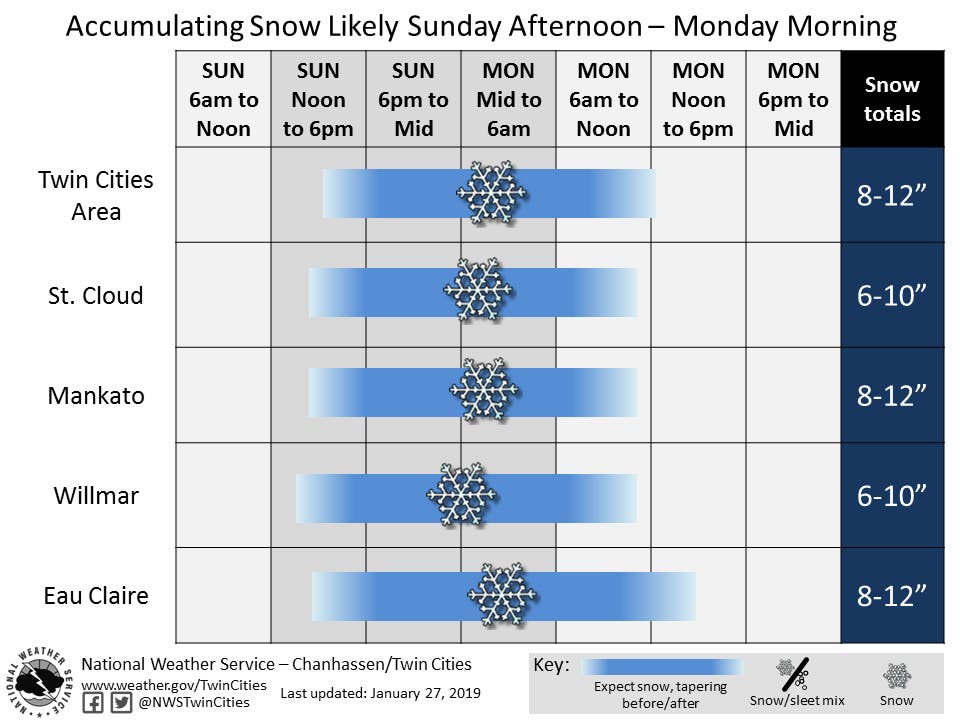
TWIN CITIES, MN — A winter storm will drop 6 to 8 inches, if not more, of snow in the area from Sunday night into Monday. Winds gusts up to 35 mph will cause blowing snow and extremely low wind chills.
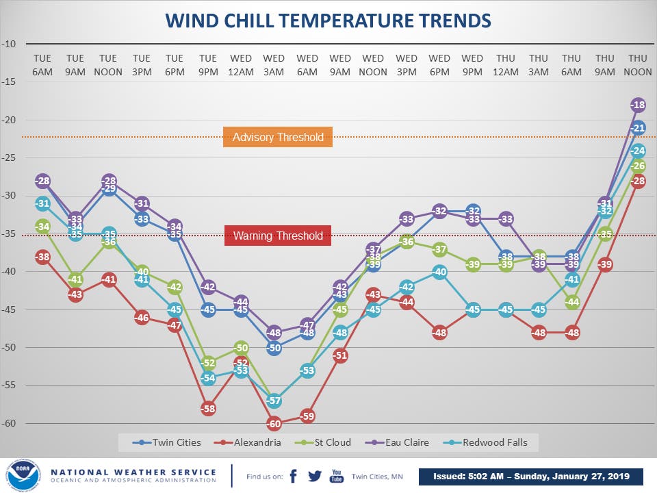
"Dangerous wind chills of below -35 degrees are expected Tuesday through Thursday morning. Please cover exposed skin and limit time outdoors," says the National Weather Service.
Also read: Minnesota School Closings: St. Paul, Minneapolis, More
Find out what's happening in Southwest Minneapolisfor free with the latest updates from Patch.
Both a winter storm warning and a wind chill watch have been issued for the Twin Cities metro area and much of central Minnesota. A winter storm warning means the snow and wind will make travel either extremely hazardous or impossible. Put a flashlight, food and water in your car before driving.
Find out what's happening in Southwest Minneapolisfor free with the latest updates from Patch.
Snowfall is pushing into the area Sunday night. Find the timing for major cities below:
Plan on slippery road conditions and poor visibility. Frostbite can happen in just 5 minutes.

Here's the NWS forecast for the Twin Cities:
Sunday: Snow, mainly after 4 p.m. High near 7. Wind chill values as low as -12. Southeast wind 5 to 15 mph. Chance of precipitation is 90 percent. Total daytime snow accumulation of 1 to 2 inches possible.
Sunday Night: Snow. The snow could be heavy at times. Patchy blowing snow after 8pm. Low around 3. Wind chill values as low as -14. Blustery, with a southeast wind 15 to 20 mph becoming north northeast after midnight. Winds could gust as high as 30 mph. Chance of precipitation is 100 percent. New snow accumulation of 4 to 8 inches possible.
Monday: Snow likely, mainly before 8am. Patchy blowing snow before 8 a.m. Mostly cloudy, with a high near 10. Wind chill values as low as -16. North wind around 15 mph. Chance of precipitation is 60 percent. New snow accumulation of less than one inch possible.
Monday Night: Mostly cloudy, with a low around -12. Wind chill values as low as -24. West northwest wind 10 to 15 mph.
Tuesday: Partly sunny and cold, with a high near -8. Northwest wind 10 to 15 mph, with gusts as high as 30 mph.
Tuesday Night: Mostly cloudy, with a low around -26. West northwest wind 10 to 15 mph, with gusts as high as 30 mph.
Wednesday: Partly sunny and cold, with a high near -13. West northwest wind 10 to 15 mph.
Wednesday Night: Partly cloudy, with a low around -25. West wind 5 to 10 mph.
Thursday: Partly sunny and cold, with a high near -2. Southwest wind around 5 mph becoming southeast in the afternoon.
Thursday Night: Mostly cloudy, with a low around -9. Southeast wind around 5 mph.
Friday: Mostly sunny, with a high near 11. East northeast wind around 5 mph becoming south in the afternoon.
Friday Night: Mostly cloudy, with a low around 3. South southeast wind 5 to 10 mph.
Saturday: A 40 percent chance of snow. Mostly cloudy, with a high near 29. South southeast wind around 10 mph.
William Bornhoft is Patch's Minnesota editor. Reach him at William.Bornhoft@Patch.com
Editor's note: this article has been updated to reflect that a winter storm warning — not a watch — is now in effect
Image via National Weather Service
Get more local news delivered straight to your inbox. Sign up for free Patch newsletters and alerts.