Weather
MN Weather: Heat Index Will Approach 100 On Thursday
Minnesotan homes will go from heating to air conditioning in about a week's time.

TWIN CITIES, MN — Following Monday's storms, the weather will crank up the heat in the Twin Cities this week. The heat index will approach 100 on Thursday.
The heat index is the summer version of wind chill. In other words, the heat index indicates how hot it will feel on a particular day.
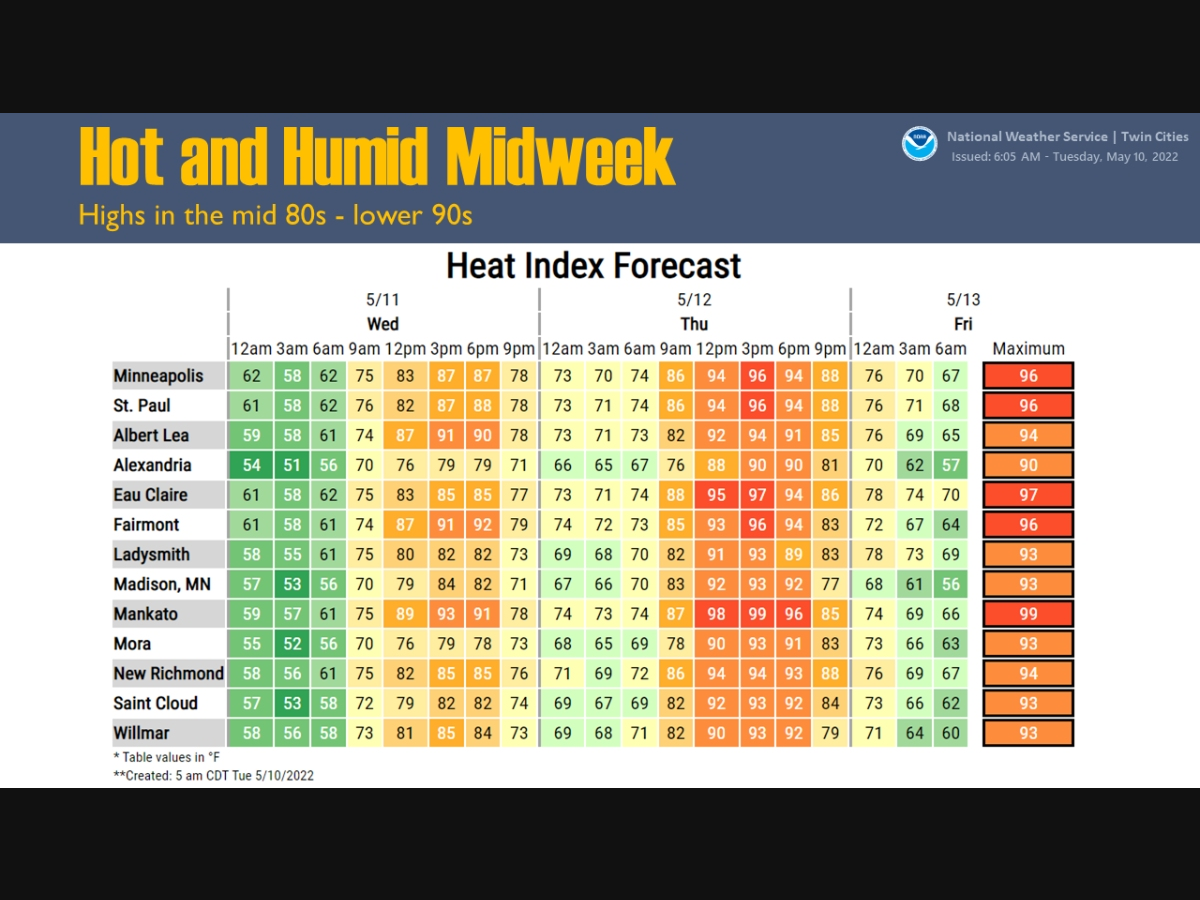
"Temperatures will heat up into the 80s and 90s Wednesday and Thursday," the National Weather Service said. "It will also be humid, which will push heat indices well into the 90s across the entire region."
Find out what's happening in Southwest Minneapolisfor free with the latest updates from Patch.
Here’s the full NWS forecast from the Minneapolis-St. Paul International Airport:
Tuesday: Mostly cloudy through mid morning, then gradual clearing, with a high near 78. North wind 5 to 10 mph.
Find out what's happening in Southwest Minneapolisfor free with the latest updates from Patch.
Tuesday Night: Clear, with a low around 57. North northeast wind around 5 mph.
Wednesday: A 40 percent chance of showers and thunderstorms, mainly after 1pm. Some storms could be severe, with large hail and damaging winds. Partly sunny, with a high near 86. East southeast wind 5 to 15 mph, with gusts as high as 25 mph.
Wednesday Night: Showers and thunderstorms. Some storms could be severe, with large hail, damaging winds, and heavy rain. Low around 70. South southeast wind 10 to 15 mph, with gusts as high as 30 mph. Chance of precipitation is 80%. New rainfall amounts between a half and three quarters of an inch possible.
Thursday: A 20 percent chance of showers and thunderstorms. Mostly sunny, with a high near 92. Breezy, with a south wind 10 to 20 mph, with gusts as high as 30 mph.
Thursday Night: Showers and thunderstorms likely, mainly before 1am. Some storms could be severe, with large hail and damaging winds. Mostly cloudy, with a low around 66. South wind 10 to 15 mph, with gusts as high as 30 mph. Chance of precipitation is 60%. New rainfall amounts between a tenth and quarter of an inch, except higher amounts possible in thunderstorms.
Friday: Partly sunny, with a high near 78. West wind around 10 mph.
Friday Night: A 20 percent chance of showers. Partly cloudy, with a low around 58. West southwest wind around 5 mph becoming south southeast after midnight.
Saturday: A 30 percent chance of showers after 1pm. Mostly sunny, with a high near 72. West wind 5 to 15 mph, with gusts as high as 25 mph.
Saturday Night: A 30 percent chance of showers, mainly before 1am. Partly cloudy, with a low around 51. West northwest wind 10 to 15 mph.
Sunday: A 20 percent chance of showers. Mostly sunny, with a high near 65. West northwest wind 10 to 15 mph, with gusts as high as 25 mph.
Sunday Night: A 20 percent chance of showers. Mostly clear, with a low around 48. Northwest wind 10 to 15 mph.
Monday: A 20 percent chance of showers. Sunny, with a high near 66. Northwest wind 10 to 15 mph.
Get more local news delivered straight to your inbox. Sign up for free Patch newsletters and alerts.


