Weather
Potential ‘Super El Niño’ Coming Faster Than Expected: What It Means For MN
NOAA says El Niño is likely to develop soon, but what that means for Minnesota is still far from certain.

MINNESOTA — A "super El Niño" could be on the way, raising the possibility of another unusually mild winter in Minnesota.
But don’t put the snowblower on Craigslist just yet.
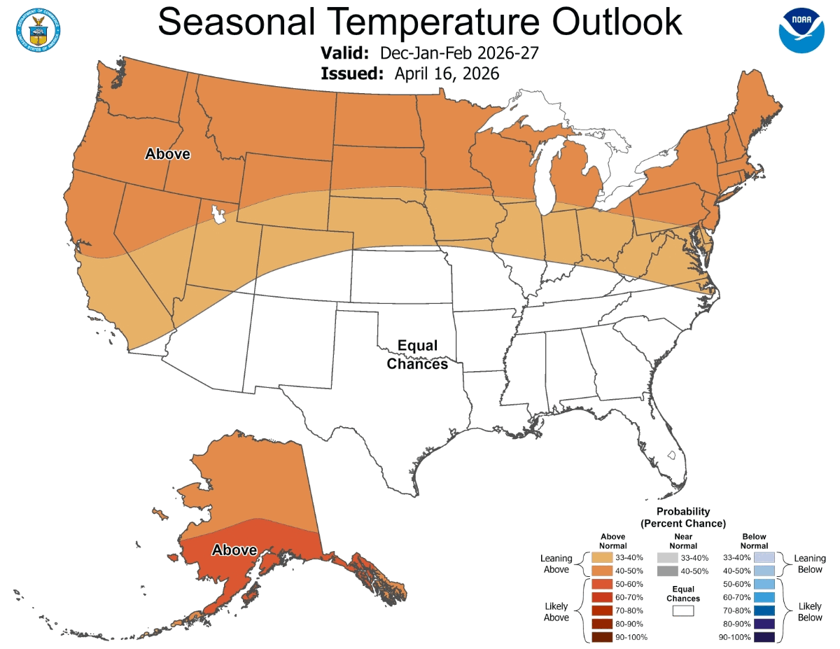
The National Oceanic and Atmospheric Administration’s Climate Prediction Center said in its latest update that El Niño is likely to develop soon, with an 82 percent chance of emerging between May and July 2026.
Find out what's happening in Southwest Minneapolisfor free with the latest updates from Patch.
Forecasters said there is also a 96 percent chance that El Niño conditions will continue through the winter of 2026-27.
ALSO READ: Minnesotans Asked To Turn Off Lights Tonight: Here's Why
Find out what's happening in Southwest Minneapolisfor free with the latest updates from Patch.
El Niño happens when sea surface temperatures in the central and eastern tropical Pacific Ocean become warmer than normal, disrupting weather patterns around the globe, according to NOAA.
In the United States, El Niño often shifts the Pacific jet stream south. That can make the northern U.S., including Minnesota, warmer and drier than usual during winter, according to NOAA.
Still, forecasters are urging caution.
NOAA said there is "substantial uncertainty" about how strong the developing El Niño will become. No strength category currently has more than a 37 percent chance, according to the Climate Prediction Center.
And even a strong El Niño does not guarantee a mild or low-snow winter in Minnesota.
What El Niño Usually Means In Minnesota
Minnesota’s El Niño winters have often been warmer than average, according to the Minnesota Department of Natural Resources.
The DNR previously reviewed 25 El Niño winters in Minnesota since 1950 and found that they averaged 1.8 degrees warmer statewide than non-El Niño winters.
Snowfall in the Twin Cities also averaged about 22 percent lower during those El Niño winters, according to the DNR.
But the numbers can vary widely from year to year.
Minnesota’s warmest winter on record came during the strong 1997-98 El Niño, when the statewide average winter temperature was 22.2 degrees, or 11.7 degrees above normal, according to the National Weather Service.
That winter was famously mild across the state.
But El Niño does not always mean Minnesota gets an easy winter.
The winter of 1982-83 was also a strong El Niño winter, and the Twin Cities still recorded 74.4 inches of snow, according to the DNR.
The National Weather Service says strong El Niño winters often bring below-normal snowfall to the Upper Mississippi River Valley, but as many as one-third of those winters have produced above-normal snowfall.
What Minnesotans Should Watch
For now, the safest takeaway is this:
El Niño can tilt the odds toward a warmer, somewhat drier winter in Minnesota, but it does not write the forecast months in advance.
A strong El Niño could increase the chances of:
- A milder-than-normal winter
- Fewer stretches of extreme cold
- Less snow than usual in some parts of the state
- More variability from storm to storm
But Minnesota can still see major snowstorms, deep cold snaps and messy winter travel during El Niño years.
NOAA is expected to keep updating its El Niño outlook in the months ahead. The clearer picture for Minnesota will come later this year, when federal forecasters release their winter outlooks.
Get more local news delivered straight to your inbox. Sign up for free Patch newsletters and alerts.


