Weather
Snowstorm Set To Hit MN Friday: Here's What We Know
"At least a few inches of accumulating snow is looking increasingly likely Friday," the National Weather Service said.

MINNEAPOLIS — A snowstorm is set to hit Minnesota Friday, but there is still a lot of unknowns. "At least a few inches of accumulating snow is looking increasingly likely Friday," the National Weather Service said.
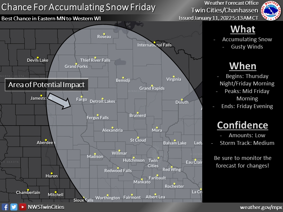
"A wide area will be affected by accumulating snow beginning Thursday night and lingering through most of Friday. The track of the storm and amount of snow will be refined over the coming days."
For now, the Twin Cities and most of the state are in the"area of potential impacts." Potential snowfall totals are not yet known.
Find out what's happening in Southwest Minneapolisfor free with the latest updates from Patch.
Today will feel almost tropical with high temperatures in the low 30s. Accumulating snow still looks likely on Friday, with a large area of potential impacts. Stay tuned for updates on the track & timing of the system, which will impact snow amounts. #mnwx #wiwx pic.twitter.com/UGt9S8ZbxW
— NWS Twin Cities (@NWSTwinCities) January 11, 2022
Here's the current NWS forecast for the Twin Cities metro area:
Tuesday: Mostly sunny, with a high near 31. South southeast wind around 10 mph becoming west in the afternoon.
Find out what's happening in Southwest Minneapolisfor free with the latest updates from Patch.
Tuesday Night: A 20 percent chance of snow after 3am. Increasing clouds, with a low around 22. West southwest wind 5 to 10 mph.
Wednesday: A 20 percent chance of snow before noon. Mostly cloudy, with a high near 31. West wind around 5 mph becoming north northwest in the afternoon.
Wednesday Night: A 20 percent chance of snow after midnight. Mostly cloudy, with a low around 17. Northwest wind around 5 mph becoming southwest in the evening.
Thursday: Mostly cloudy, with a high near 27. West northwest wind around 5 mph becoming north in the afternoon.
Thursday Night: A 40 percent chance of snow after midnight. Mostly cloudy, with a low around 17. North northeast wind 5 to 10 mph becoming east after midnight.
Friday: Snow likely. Mostly cloudy, with a high near 24. East wind around 10 mph. Chance of precipitation is 60%. Little or no snow accumulation expected.
Friday Night: A 40 percent chance of snow before midnight. Mostly cloudy, with a low around 8. Northeast wind 5 to 10 mph.
Saturday: Mostly sunny, with a high near 20. North northeast wind around 5 mph becoming south southwest in the afternoon.
Saturday Night: Mostly cloudy, with a low around 10. South wind 5 to 10 mph.
Sunday: Partly sunny, with a high near 29. South southwest wind around 10 mph becoming west in the afternoon.
Sunday Night: Mostly cloudy, with a low around 9. West northwest wind around 10 mph.
M.L.King Day: Mostly sunny, with a high near 18. Northwest wind 5 to 10 mph.
Get more local news delivered straight to your inbox. Sign up for free Patch newsletters and alerts.