Weather
Snowstorm Will Arrive In Middle Of Wild Weather Week: WI Forecast
Buckle up for a wild week of February weather that could feature both new snow and temperatures near 70 degrees in Wisconsin.


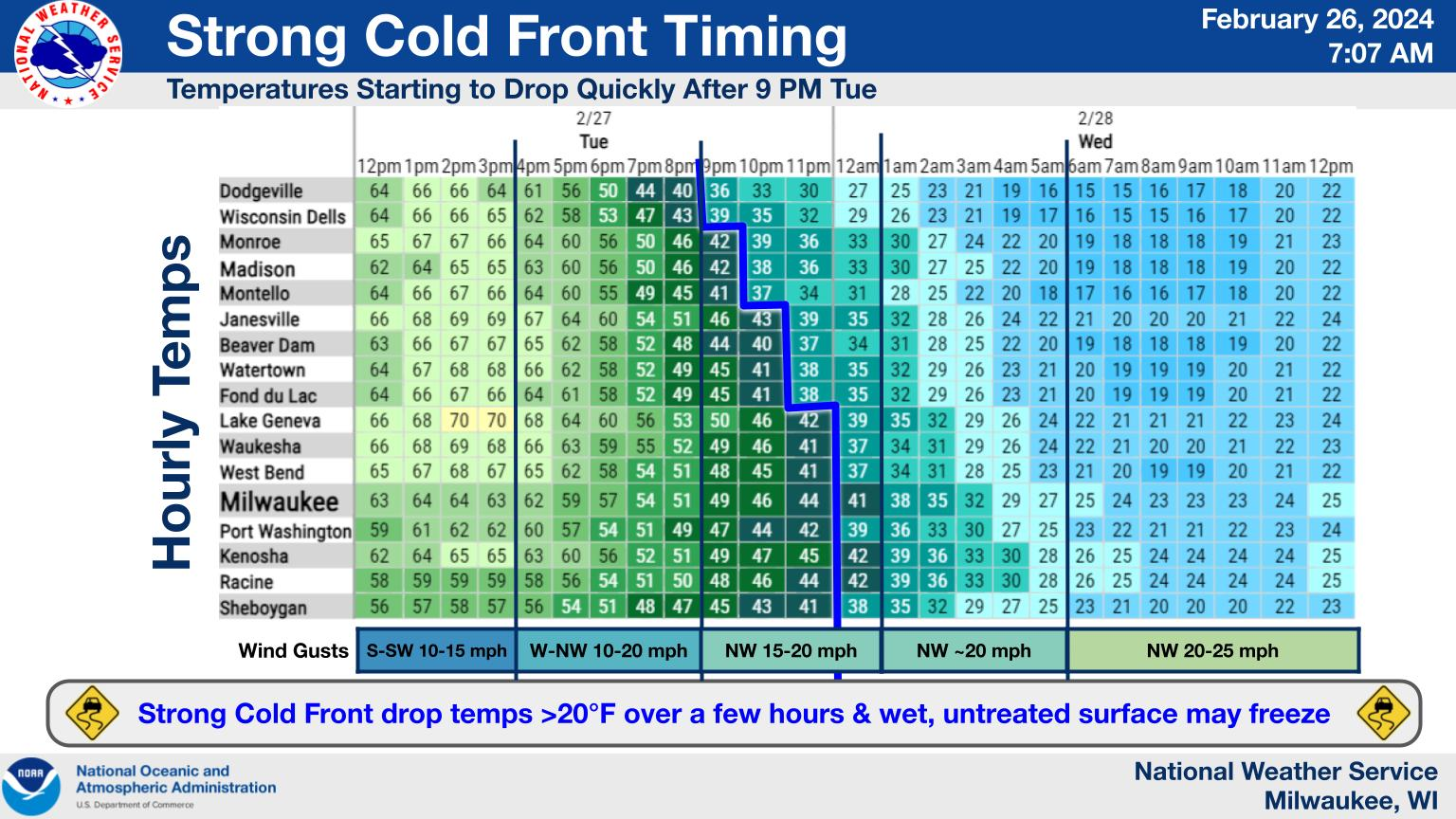
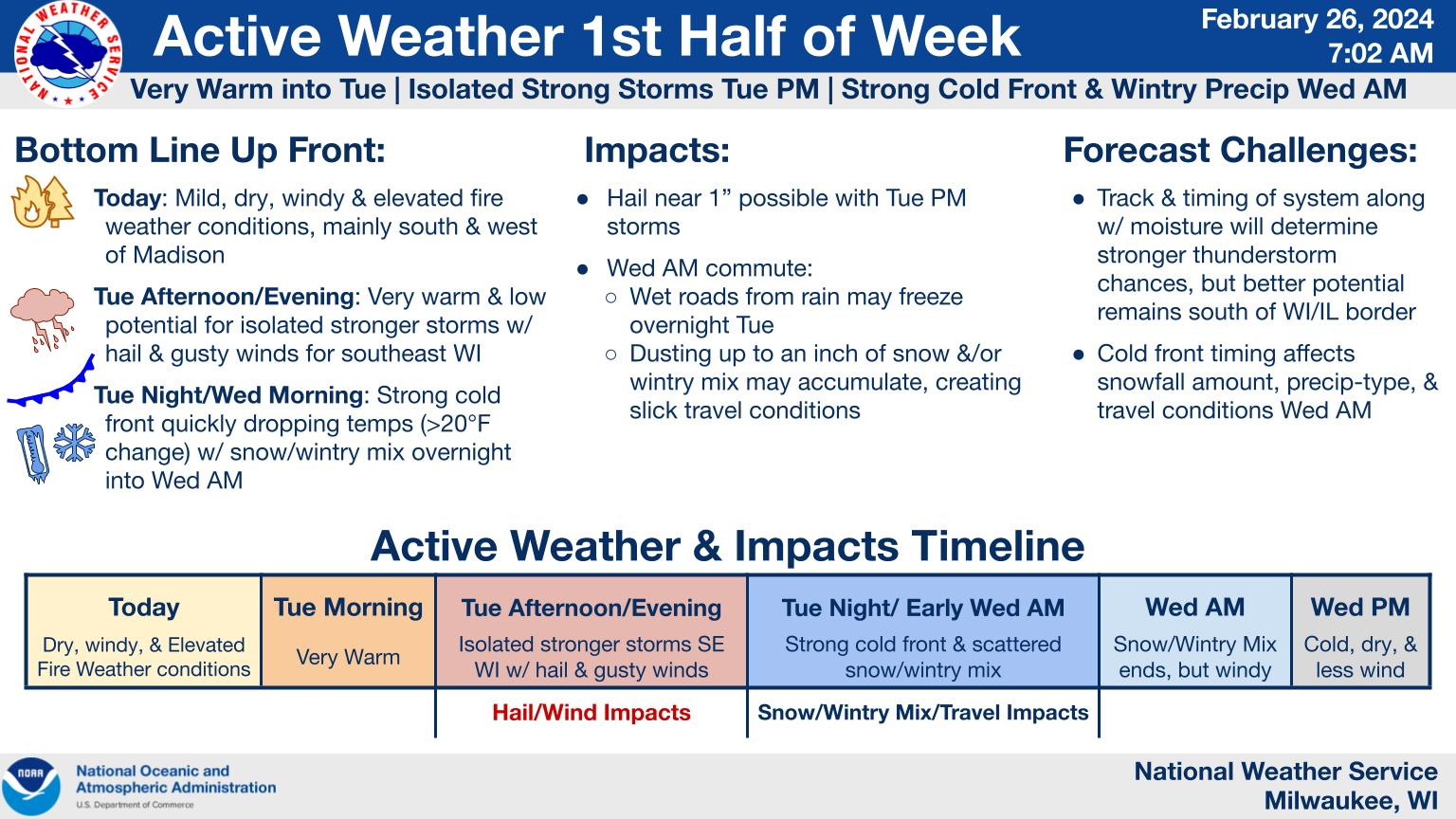
MILWAUKEE — Buckle up for a wild week of February weather that could feature both new snow and temperatures near 70 degrees in Wisconsin. After a warm and sunny start to the week, temperatures "strong Arctic cold front" will drop temperatures by more than 20 degrees Tuesday night.
"Strong cold front slides through overnight Tuesday through early Wednesday morning," the NWS said.
"Slick travel conditions possible as untreated, wet surfaces from earlier rainfall may freeze with temps dropping more than 20 degrees in a few hours overnight Tuesday into Wednesday morning, along with a dusting up to an inch of snowfall and/or wintry mix accumulations. Also expecting windy conditions behind the front along with the colder temps."
Find out what's happening in Southwest Minneapolisfor free with the latest updates from Patch.
Here's the week-ahead NWS forecast from the Milwaukee Airport:
Monday: Mostly sunny, with a high near 58. Southeast wind 5 to 15 mph.
Find out what's happening in Southwest Minneapolisfor free with the latest updates from Patch.
Monday Night: Partly cloudy, with a low around 47. South wind 5 to 10 mph.
Tuesday: A slight chance of showers between 1pm and 4pm, then a chance of showers and thunderstorms after 4pm. Partly sunny, with a high near 69. South wind 5 to 10 mph. Chance of precipitation is 30%.
Tuesday Night: Rain showers likely before 1am, then rain and snow showers between 1am and 4am, then snow showers after 4am. Some thunder is also possible. Low around 22. Blustery, with a south wind 5 to 10 mph becoming northwest 15 to 20 mph after midnight. Winds could gust as high as 30 mph. Chance of precipitation is 80%. New snow accumulation of less than a half inch possible.
Wednesday: Snow showers, mainly before 7am. High near 30. Blustery, with a northwest wind around 20 mph, with gusts as high as 35 mph. Chance of precipitation is 80%. New snow accumulation of less than a half inch possible.
Wednesday Night: Mostly clear, with a low around 18. Blustery, with a northwest wind 10 to 20 mph, with gusts as high as 30 mph.
Thursday: Sunny, with a high near 42. Breezy, with a south wind 10 to 20 mph, with gusts as high as 30 mph.
Thursday Night: Mostly clear, with a low around 32. Breezy, with a south wind around 20 mph, with gusts as high as 30 mph.
Friday: Sunny, with a high near 51.
Friday Night: Mostly clear, with a low around 38.
Saturday: Sunny, with a high near 59.
Saturday Night: Partly cloudy, with a low around 45.
Sunday: Partly sunny, with a high near 60.
Get more local news delivered straight to your inbox. Sign up for free Patch newsletters and alerts.