Community Corner
Why Did the Massive Winter Storm Jonas Miss NH?
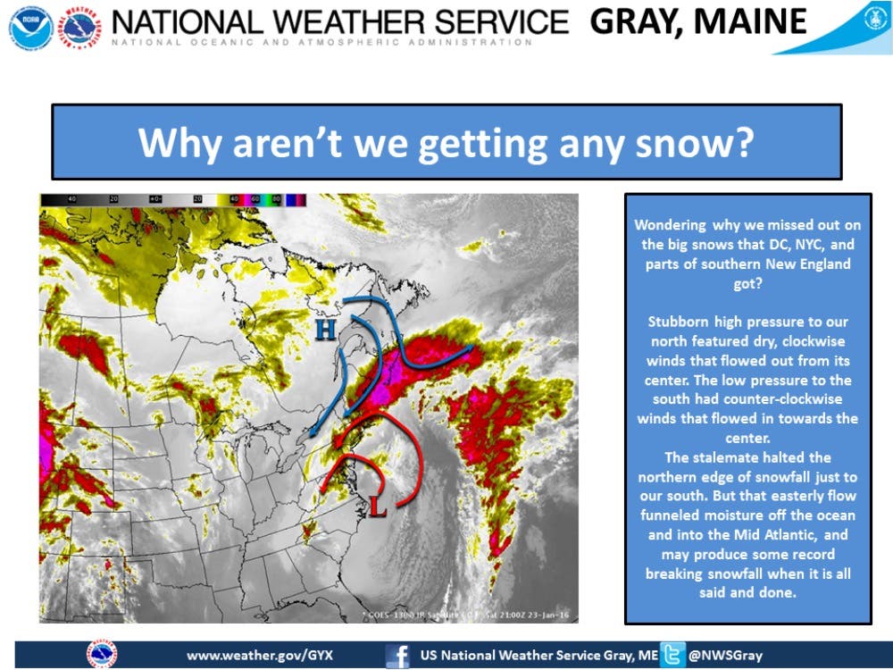
As up to 40 inches of snow hits parts of the Northeast, National Weather Service forecasters explain why the Granite State was spared.

While most of the Northeast is buried under more than three feet of snow in some places, causing flooding, thousands to lose power, some to be stranded, as well as death, and destruction, the Granite State escaped without much beyond a flurry and some wind.
Most of us are still healing from last year’s bombardment of the white stuff, so it’s OK this missed us. But why did it miss New Hampshire?
Forecasters for the National Weather Service in Gray, ME, the team that covers weather for our state, explained in a post on Facebook says that a stubborn high pressure system to the north is swirling – and battling – with the low pressure storm system in the south. The high-pressure system is swirling clockwise; the snowstorm is spinning counter-clockwise.
Find out what's happening in Amherstfor free with the latest updates from Patch.
“The stalemate halted the northern edge of snowfall just to our south,” forecasters reported. “But that easterly flow funneled moisture off the ocean and into the mid-Atlantic, and may produce some record breaking snowfall when it is all said and done.”
As of just before 8 p.m., New York City was getting close to its all-time record of 26.1 inches. Philadelphia, which received 17 inches, broke its 11 inch in 24 hours record tonight. Some locations in West Virginia received 40 inches on Jan. 23, 2016. And the storm is still going on …
Find out what's happening in Amherstfor free with the latest updates from Patch.
Graphic by the National Weather Service
Get more local news delivered straight to your inbox. Sign up for free Patch newsletters and alerts.