Health & Fitness
Unprecedented & Historic October Snowstorm
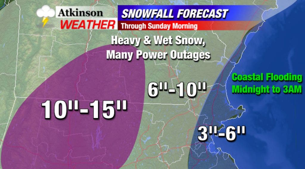
A high-impact, unprecedented October snowstorm will bring many inches of snow to the region overnight. Widespread power outages are expected.
WOW! That is all I have to say. It's been a long week of forecasting over on my website AtkinsonWeather.com - I've had little time to spare, so didn't have a chance to update my blog over here on Patch.
Nonetheless, an incredible and unprecedented storm for October and this time of the year is impacting New England tonight. At 8 p.m., some spots in western Massachusetts were reporting close to 16 inches of snow! Here in southeastern New Hampshire, two to four inches has fallen so far.
Connecticut has seen massive power outages - hundreds of thousands without power tonight. As of now, they are at their second highest number of people without power ever. (Second to Irene!)
Find out what's happening in Salemfor free with the latest updates from Patch.
Similar results are now being felt locally, with outages in every local town. Even only a few inches of this wet, heavy snow can cause power outages with the leaves still on the trees. Add the wind to the equation later tonight (gusts 30 to 50 mph), and more outages are expected. Have the flashlights and batteries on hand.
In total, I'm expecting 6 to 10 inches of snow by morning. Even more is expected farther west in the higher elevations of the Monadnock Region. Lesser amounts (3 to 6 inches) are expected near the immediate coast, where snow has had a more difficult time accumulating.
Find out what's happening in Salemfor free with the latest updates from Patch.
Regardless of the exact snowfall emounts, this is an epic and high-impact event for many, due to the power outages. Let's hope this is the exception, not the rule, for the winter ahead.
If you're into weather or looking for more updates, follow me on Twitter @AtkinsonWeather or visit my website AtkinsonWeather.com.
Ryan Breton