Weather
Big Weather Shift Coming To NJ: See New Forecast
Snow, rain, ice, tornadoes, heat, cold: it's all hit the Garden State in the past few weeks, and stability is not on the immediate radar.

Seasons seem to be less distinct in the New Jersey area than ever before, with hints of just about every type of major weather pattern hitting the area over the past several weeks. The next dramatic shift up: spring and summer-like sun, forecasters said.
While Tuesday and Wednesday saw highs barely escape the 30s, the slight warming early Thursday is just the beginning.
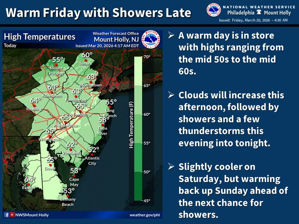
The National Weather Service said the warming trend will continue through the weekend.
Find out what's happening in Across New Jerseyfor free with the latest updates from Patch.
Highs will rise to 62 by Friday, 65 on Saturday, and all the way up to 70 in some parts of the region on Sunday, forecasters said.
Some light to moderate rainfall is possible in two main bursts: Friday night, with a 70 percent chance of showers and up to a quarter inch falling, and a lesser storm Sunday night into Monday morning.
Find out what's happening in Across New Jerseyfor free with the latest updates from Patch.
Some light to moderate rainfall is possible in two main bursts: Friday night, with a 70 percent chance of showers and up to a quarter inch falling, and a lesser storm Sunday night into Monday morning.
Shifts in the jet stream are likely to continue to bring cold air down across the midwest and northeast over the coming weeks, according to Accuweather, interspersed with more warming periods.
"Additional back-and-forth swings between warm and chilly air will continue into April, especially across the Northeast," Accuweather said.
Here's the full forecast for New Jersey over the coming week:
Thursday
Mostly cloudy, with a high near 50. Southwest wind around 5 mph.
Thursday Night
Partly cloudy, with a low around 36. South wind around 5 mph becoming calm in the evening.
Friday
Increasing clouds, with a high near 62. South wind 5 to 10 mph increasing to 10 to 15 mph in the afternoon. Winds could gust as high as 30 mph.
Friday Night
Showers likely, mainly between 8 p.m. and 2 a.m. Mostly cloudy, with a low around 48. Southwest wind 5 to 15 mph. Chance of precipitation is 70%. New precipitation amounts between a tenth and quarter of an inch possible.
Saturday
Sunny, with a high near 65. Northwest wind 5 to 10 mph.
Saturday Night
Mostly cloudy, with a low around 45.
Sunday
Partly sunny, with a high near 70.
Sunday Night
Rain likely, mainly after 2 a.m. Mostly cloudy, with a low around 45. Chance of precipitation is 60 percent.
Monday
Rain likely, mainly before 8 a.m. Partly sunny, with a high near 54. Chance of precipitation is 60 percent.
Monday Night
Mostly clear, with a low around 29.
Tuesday
Mostly sunny, with a high near 47.
Tuesday Night
Mostly cloudy, with a low around 33.
Wednesday
Mostly sunny, with a high near 53.
MORE FROM PATCH: Former South Jersey Educator Writes Children's Book
HAVE A STORY IDEA OR NEWS TO SHARE? Contact Editor Eddie Callahan at edward.callahan@patch.com to connect with Patch in your area.
Get more local news delivered straight to your inbox. Sign up for free Patch newsletters and alerts.