Weather
Winter Weather Advisory Expands Ahead Of NJ Christmas Eve Storm
A wintry mix on the morning of Christmas Eve could make for slick roads on one of the busiest travel days of the year.

NEW JERSEY — A wintry mix of freezing rain and light snow will coat New Jersey in a Christmas Eve storm, potentially glazing the roads with ice on one of the busiest travel days of the year, according to the latest forecast.
Following a bitterly cold Monday, a clipper system slides into the region and snow is on tap for the morning of Dec. 24, the National Weather Service said.
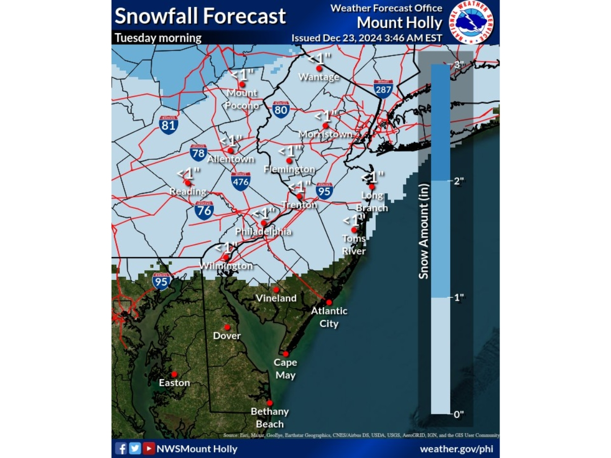
Specifically in the Philadelphia region, temperatures will warm just enough for snow to change to freezing rain, making untreated roads icy and treacherous. The National Weather Service urges those driving Tuesday morning to plan for extra time.
Find out what's happening in Across New Jerseyfor free with the latest updates from Patch.
"Commuters across the region should stay weather-aware and be careful for slick conditions, particularly on elevated surfaces like bridges and overpasses," AccuWeather forecasters warned.
The National Weather Service issued a Special Weather Statement for most of New Jersey ahead of the storm.
Find out what's happening in Across New Jerseyfor free with the latest updates from Patch.
"While any accumulations will be very light, cold road temperatures may result in very slippery conditions within a short period after precipitation starts," the statement said. Snow and freezing rain is anticipated in Ocean, Cumberland, Atlantic and southeastern Burlington counties. Light snow is predicted in Sussex, Warren, Morris, Hunterdon, Somerset, Middlesex, Monmouth and Mercer counties.
"Roads will become snow covered due to the recent cold weather resulting in slippery travel conditions," the National Weather Service said in the statement for Passaic, Bergen, Essex, Union and Hudson counties.
A Winter Weather Advisory has been issued from 5 a.m. to 1 p.m. Tuesday for Salem, Gloucester and Camden counties because of the sleet potential. This also extends into northwestern Burlington County.
The rest of the state could see a light dusting of snow up to 1 inch, but you shouldn't really expect any accumulations, forecasters say.
Precipitation will taper off by midday, making for a cold, but dry, evening, according to the forecast.
Christmas Eve night and Christmas Day are expected to be dry with mostly clear skies, though a stray flurry may fall Christmas night.
Here's the latest forecast.
North Jersey
Monday: Sunny, with a high near 25. Calm wind becoming south around 5 mph.
Monday Night: Increasing clouds, with a low around 20. Calm wind becoming southwest around 5 mph.
Tuesday: Snow likely, mainly before 9 a.m. Cloudy, then gradually becoming mostly sunny, with a high near 38. Southwest wind around 5 mph. Chance of precipitation is 60 percent. New snow accumulation of less than a half inch possible.
Tuesday Night: Partly cloudy, with a low around 23. North wind around 5 mph.
Christmas Day: Mostly sunny, with a high near 34. North wind around 5 mph becoming calm in the afternoon.
Wednesday Night: Partly cloudy, with a low around 20.
Thursday: Mostly sunny, with a high near 35.
Thursday Night: Partly cloudy, with a low around 21.
Friday: Mostly sunny, with a high near 38.
Central Jersey
Monday: Sunny, with a high near 29. North wind around 5 mph becoming calm.
Monday Night: Mostly cloudy, with a low around 21. Calm wind becoming southwest around 5 mph.
Tuesday: Snow likely, mainly between 9 a.m. and noon. Cloudy, then gradually becoming mostly sunny, with a high near 39. Southwest wind around 5 mph becoming west in the afternoon. Chance of precipitation is 60 percent. New snow accumulation of less than a half inch possible.
Tuesday Night: Partly cloudy, with a low around 23. North wind around 5 mph.
Christmas Day: Mostly sunny, with a high near 37. North wind around 5 mph.
Wednesday Night: Mostly cloudy, with a low around 21.
Thursday: Partly sunny, with a high near 37.
Thursday Night: Mostly clear, with a low around 21.
Friday: Mostly sunny, with a high near 41.
South Jersey
Monday: Sunny, with a high near 31. Calm wind.
Monday Night: Mostly cloudy, with a low around 21. Calm wind.
Tuesday: Rain, snow, and freezing rain likely before 11 a.m., then a chance of rain between 11 a.m. and 1 p.m. Cloudy, then gradually becoming mostly sunny, with a high near 41. Southwest wind around 5 mph becoming northwest in the afternoon. Chance of precipitation is 60 percent. Little or no ice accumulation expected. New snow accumulation of less than a half inch possible.
Tuesday Night: Partly cloudy, with a low around 24. Calm wind becoming north around 5 mph after midnight.
Christmas Day: Mostly sunny, with a high near 40. North wind around 5 mph.
Wednesday Night: Mostly cloudy, with a low around 21.
Thursday: Mostly sunny, with a high near 40.
Thursday Night: Partly cloudy, with a low around 23.
Friday: Mostly sunny, with a high near 45.
Get more local news delivered straight to your inbox. Sign up for free Patch newsletters and alerts.