Weather
It Could Feel Like 107 This Week In NJ As Extreme Heat Returns
Dangerous heat is expected for New Jersey Wednesday, according to the latest forecast.


Heat watches and advisories will be in place this week as New Jersey braces for dangerous heat and heat index values of up to 107 degrees.
The extreme heat will be brief; however, it will be a hot and humid week with high temperatures in the upper-80s to mid-90s Tuesday through at least Friday, National Weather Service forecasters said.
"The heat peaks on Wednesday over the area as temperatures should get well into the 90s with increasing humidity," the National Weather Service said.
Find out what's happening in Across New Jerseyfor free with the latest updates from Patch.
The extreme heat is moving in from the Midwest where it already has set records, the weather service said.
An extreme heat watch will be in place Wednesday for Mercer, Camden, Gloucester, western Monmouth, Somerset, Ocean, Middlesex and Burlington counties, with heat index values up to 106 possible.
Find out what's happening in Across New Jerseyfor free with the latest updates from Patch.
Starting Tuesday afternoon and into Wednesday evening, Passaic, Hudson, Bergen, Essex and Union counties will be under a heat advisory, with heat index values up to 101 possible.
Heat advisories have also been issued in Salem, Cumberland, Atlantic and Cape May counties, with heat index values up to 107 expected.
Morris, Sussex, Warren and Hunterdon counties will be under a heat advisory as well.
Expect little relief at the beach, as eastern Monmouth, coastal Ocean, coastal Atlantic and coastal Cape May counties could feel like 105 degrees.
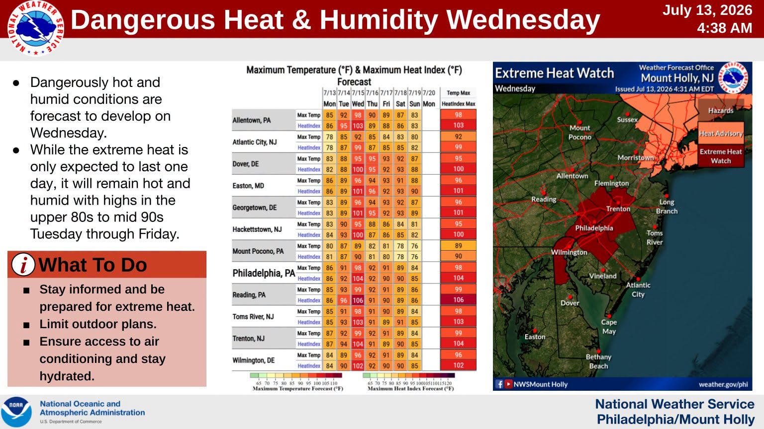
"A dry cold front looks to pass sometime late Wednesday which will knock down temperatures a bit, but medium range guidance and ensembles indicate above normal temperatures in the upper-80s/low-90s could remain through the end of the week and potentially into the weekend," the National Weather Service said.
By late week and into the weekend, there is another possibility of showers and thunderstorms, with some being severe, forecasters said.
However, as it is several days out, it is too early to know the details and potential impacts.
Get more local news delivered straight to your inbox. Sign up for free Patch newsletters and alerts.