Weather
Flood Watch For 11 NJ Counties: See Thursday Storm Timeline
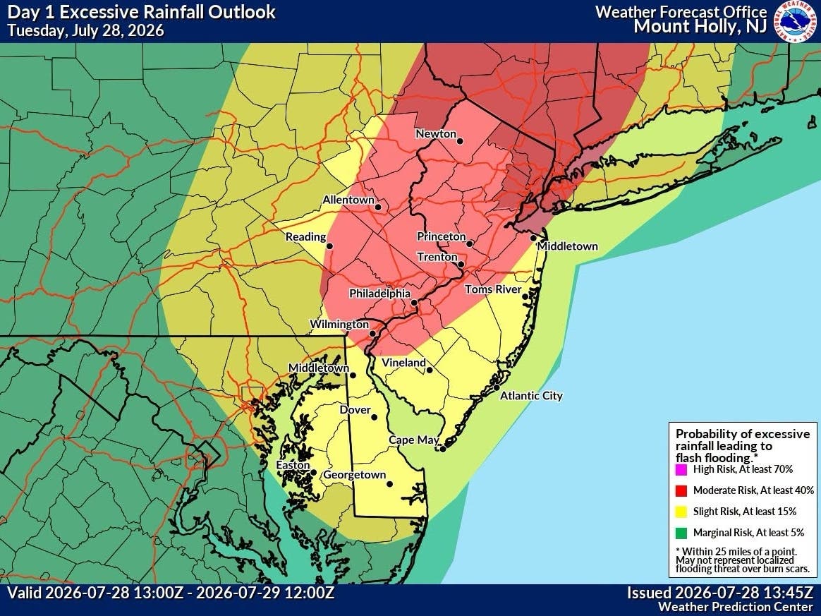
Flash flooding caused by excessive rainfall is possible in some parts of NJ today. Here's what to expect.

NEW JERSEY - Thunderstorms and heavy rain in New Jersey may cause flooding in parts of the state on Thursday, forecasters say.
As of 2:30 p.m., 11 Garden State counties are currently under a flood watch issued by the National Weather Service. Those counties are:
- Sussex
- Warren
- Morris
- Hunterdon
- Somerset
- Middlesex
- Mercer
- Salem
- Gloucester
- Camden
- Burlington
The flood watch is in effect until 2 a.m. on Friday.
Find out what's happening in Across New Jerseyfor free with the latest updates from Patch.
3:30 p.m. update: Passaic, Bergen, Essex and Union have been added to the National Weather Service's flood watch list.
Several rounds of showers will move through the region today into the late night, bringing between 1.5 to 2.5 inches of rainfall, the National Weather Service said in a statement. Amounts could be higher during thunderstorms, bringing the potential for flash flooding.
Find out what's happening in Across New Jerseyfor free with the latest updates from Patch.
Rainfall amounts are expected to be the highest this evening north and west of I-95, the National Weather Service said, with up to two inches of rainfall expected. This round of storms should move offshore by the late evening, although another round of scattered showers is expected to come again in the wee hours of Friday morning.
“Excessive runoff may result in flooding of creeks, streams, and other low-lying and flood-prone locations,” the weather agency said. “Flooding may occur in poor drainage and urban areas. Low-water crossings may be flooded.”
New Jersey residents are urged to monitor the latest weather forecasts and be prepared to take action should flash flood warnings be issued.
Thursday is predicted to see a high of 55 degrees with up to 25 mph wind gusts. Friday should be mostly sunny during the day with highs in the low 60s, although there’s still a chance of showers in the evening.
Here’s the latest forecast:
Thursday: Showers and possibly a thunderstorm. Some of the storms could produce heavy rain. High near 52. East wind around 15 mph, with gusts as high as 25 mph. Chance of precipitation is 100 percent. New rainfall amounts between a half and three quarters of an inch possible.
Thursday Night: Showers and thunderstorms, mainly before 2 a.m. Some of the storms could produce heavy rain. Low around 46. East wind 5 to 10 mph becoming west after midnight. Winds could gust as high as 25 mph. Chance of precipitation is 100 percent. New rainfall amounts between 1 and 2 inches possible.
Friday: Mostly sunny, with a high near 61. Southwest wind 5 to 10 mph, with gusts as high as 20 mph.
Friday Night: A chance of showers, mainly after 8 p.m. Mostly cloudy, with a low around 43. South wind around 5 mph. New precipitation amounts of less than a tenth of an inch possible.
Get more local news delivered straight to your inbox. Sign up for free Patch newsletters and alerts.