Weather
All Of NJ Under Severe Thunderstorm Warning; Tornadoes & Hail Possible
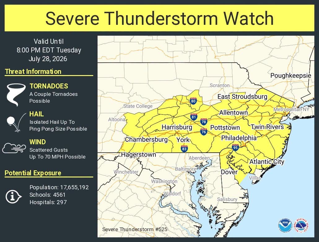
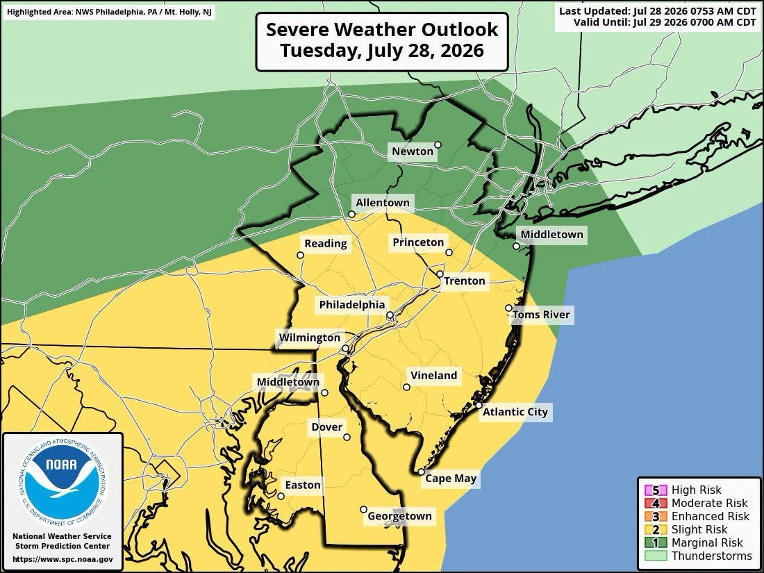
The severe thunderstorm could produce tornadoes, isolated hail up to ping-pong size and scattered gusts up to 70 mph.



A severe thunderstorm watch has been expanded to encompass the entire state of New Jersey and multiple counties have been put under a tornado watch.
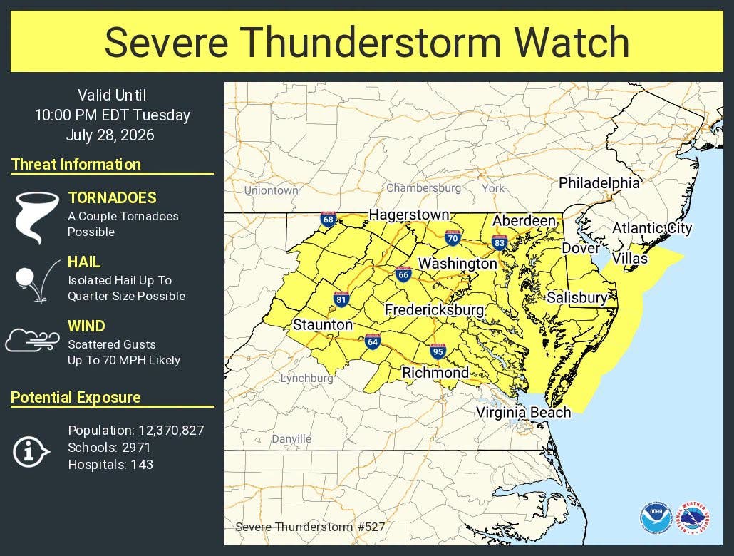
"The northern watch is in effect until 8 p.m., whereas the southern watch is in effect until 10 p.m., according to the U.S. National Weather Service(NWS).
The watch is in effect for Ocean, Camden, Atlantic, Burlington, Cumberland, Gloucester, and Salem counties until 10 p.m.
Find out what's happening in Across New Jerseyfor free with the latest updates from Patch.
"Thunderstorms tracking eastward across southeast Pennsylvania and northern Virginia will move through the watch area this afternoon. Damaging winds remain the primary threat," NWS said. "However, supercell storms may result in a few tornadoes."
The National Weather Service asked that residents monitor their local forecasts closely and move to an interior room on the lowest floor of a sturdy building if a tornado warning is issued.
Find out what's happening in Across New Jerseyfor free with the latest updates from Patch.
The severe thunderstorms could produce tornadoes, isolated hail up to ping-pong size and scattered gusts up to 70 mph.
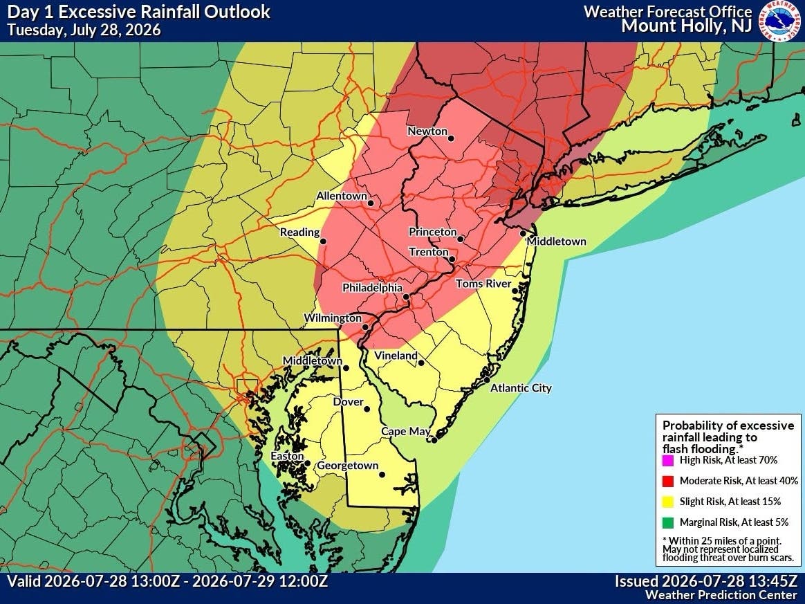
The NWS previously expanded its moderate risk for excessive rainfall to the south and west along the I-95 corridor through Wilmington.
"This means within this zone instances of flash flooding could be numerous with significant flash flooding possible," according to the NWS.
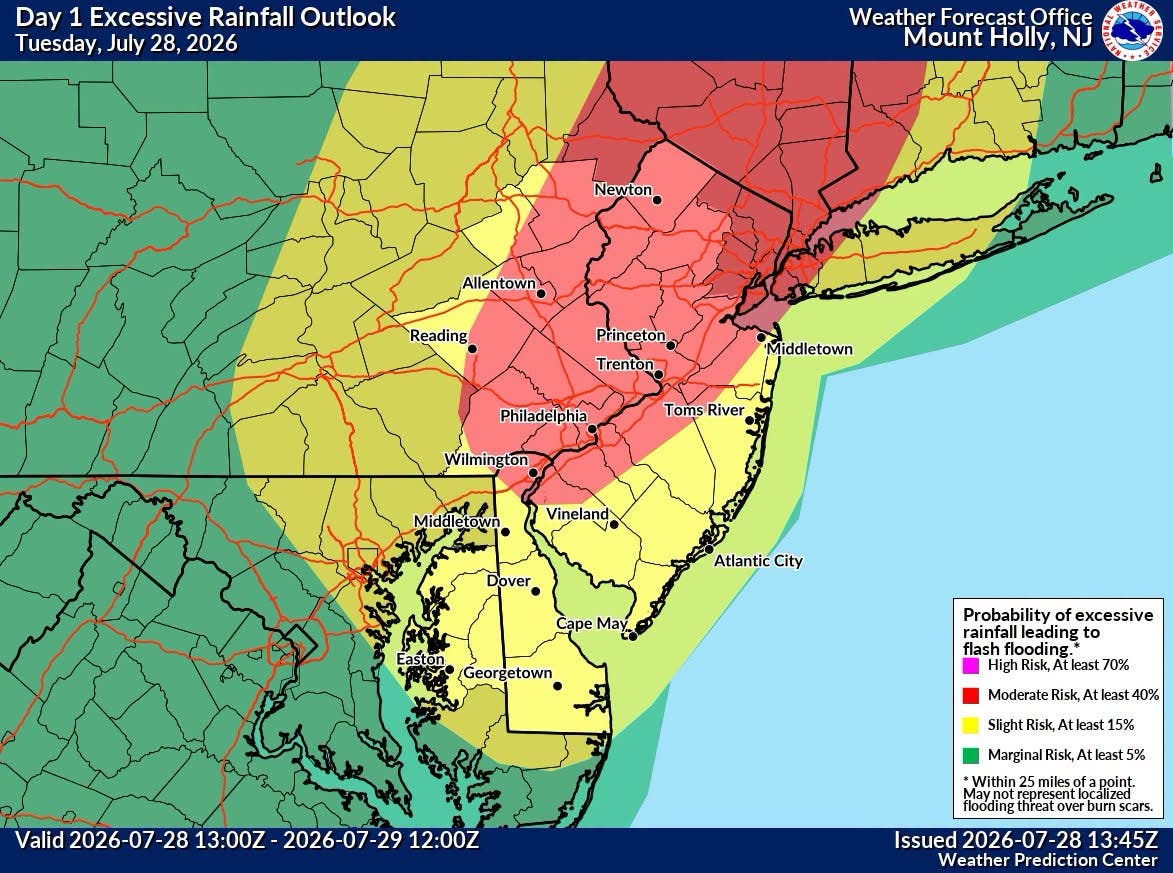
Additionally, the slight risk for severe thunderstorms issued has been expanded farther north across eastern Pennsylvania and portions of southern and central New Jersey.
Flooding
The U.S. National Weather Service(NWS) issued a flood watch for almost the entire state from 8 a.m. on Tuesday to 2 p.m. Wednesday for anywhere south of Interstate 78.
The watch is extended to 8 a.m. on Tuesday to 8 p.m. on Wednesday for areas along and north of I-78.
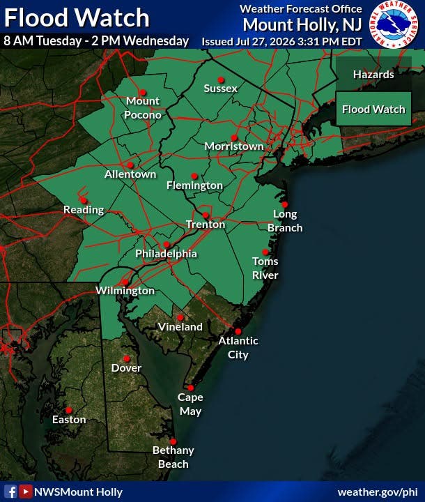
The NWS reported that widespread showers and thunderstorms are expected to affect the entire region Tuesday, with parts of North Jersey facing a higher risk for excessive rainfall.
Some areas around Sussex could see rainfall amounts of up to four inches and three inches around Morristown. That number decreases in South Jersey to around 2 inches of rain in Trenton and one inch in Toms River.
The excess rainfall has put the entire state at risk of flash flooding.
North Jersey is under a level 3 flash-flood threat, while South Jersey is under a level 2.
"Mainstream river flooding is not currently forecasted, but locally heavy rainfall could lead to significant rises on nearby rivers resulting in a risk of river flooding," according to the NWS.
The NWS expects most of the widespread flash-flood threat to begin Tuesday afternoon and continue through Tuesday night.
"Never try to drive through a flooded road - turn around, don't drown!" said the NWS.
Damaging Winds
Along with heavy rain, "damaging wind gusts are the main threat," and a few tornadoes are possible.
The threat is expected between 2 and 10 p.m. and greatest in the southeast Pennslyvania, southern New Jersey, and Delmarva areas.
The weather service also warns of frequent cloud-to-ground lightning that will be hazardous to anyone caught outdoors without shelter.
"Have multiple ways to receive warnings and stay weather aware!" said the NWS.
Upcoming Forecast
Here is a look at the upcoming forecast for the week.
North Jersey
Tuesday: A chance of showers and thunderstorms, then showers and possibly a thunderstorm after 2 p.m. Some of the storms could produce heavy rainfall. High near 80. Light south wind increasing to 5 to 10 mph in the morning. Winds could gust as high as 20 mph. Chance of precipitation is 80 percent. New rainfall amounts between a half and three-quarters of an inch possible.
Tuesday Night: Showers and thunderstorms before 3 a.m., then showers likely. Some of the storms could produce heavy rainfall. Low around 64. South wind around 5 mph becoming calm after midnight. Chance of precipitation is 90 percent. New rainfall amounts between 1 and 2 inches possible.
Wednesday: Showers and thunderstorms likely, mainly before 4 p.m. Partly sunny, with a high near 78. West wind around 5 mph. Chance of precipitation is 60 percent. New rainfall amounts between a quarter and half of an inch possible.
Wednesday Night: Showers and thunderstorms likely. Mostly cloudy, with a low around 63. Northwest wind around 5 mph. Chance of precipitation is 60 percent. New precipitation amounts between a tenth and quarter of an inch, except higher amounts possible in thunderstorms.
Thursday: A chance of showers, with thunderstorms also possible after 2 p.m. Mostly cloudy, with a high near 77. North wind around 10 mph, with gusts as high as 20 mph. Chance of precipitation is 50 percent. New rainfall amounts of less than a tenth of an inch, except higher amounts possible in thunderstorms.
Thursday Night: A chance of thunderstorms before 8 p.m. Partly cloudy, with a low around 62. Chance of precipitation is 30 percent. New precipitation amounts of less than a tenth of an inch, except higher amounts possible in thunderstorms.
Central Jersey
Tuesday: A chance of showers and thunderstorms, then showers and possibly a thunderstorm after 2 p.m. High near 82. Light south wind increasing to 5 to 10 mph in the morning. Winds could gust as high as 20 mph. Chance of precipitation is 80%. New rainfall amounts between a quarter and half of an inch possible.
Tuesday Night: Showers and thunderstorms before 2 a.m., then a chance of showers. Some of the storms could produce heavy rainfall. Low around 64. Southeast wind around 5 mph becoming calm in the evening. Chance of precipitation is 90 percent. New rainfall amounts between three-quarters and one inch possible.
Wednesday: Showers and thunderstorms likely, mainly before 4 p.m. Partly sunny, with a high near 81. West wind around 5 mph. Chance of precipitation is 70 percent. New rainfall amounts of less than a tenth of an inch, except higher amounts possible in thunderstorms.
Wednesday Night: Showers and thunderstorms likely before 11 p.m., then a chance of showers. Mostly cloudy, with a low around 62. West wind around 5 mph. Chance of precipitation is 60 percent. New precipitation amounts between a tenth and a quarter of an inch, except higher amounts possible in thunderstorms.
Thursday: A slight chance of showers, then a chance of showers and thunderstorms after 2 p.m. Partly sunny, with a high near 79. North wind 5 to 10 mph. Chance of precipitation is 50 percent. New rainfall amounts of less than a tenth of an inch, except higher amounts possible in thunderstorms.
Thursday Night: A chance of showers and thunderstorms before 8 p.m. Partly cloudy, with a low around 62. Chance of precipitation is 30 percent. New precipitation amounts of less than a tenth of an inch, except higher amounts possible in thunderstorms.
South Jersey
Tuesday: A chance of showers and thunderstorms before 3 p.m., then showers likely and possibly a thunderstorm between 3 and 5 p.m., then showers and thunderstorms likely after 5 p.m. Mostly cloudy, with a high near 84. South wind 5 to 15 mph. Chance of precipitation is 60 percent. New rainfall amounts between a tenth and a quarter of an inch, except higher amounts possible in thunderstorms.
Tuesday Night: Showers and thunderstorms likely before 2 a.m., then a chance of showers. Mostly cloudy, with a low around 66. South wind 5 to 10 mph, with gusts as high as 20 mph. Chance of precipitation is 70 percent. New rainfall amounts between a quarter and half of an inch possible.
Wednesday: A chance of showers and thunderstorms after 3 p.m. Mostly sunny, with a high near 85. West wind around 5 mph. Chance of precipitation is 30 percent. New rainfall amounts of less than a tenth of an inch, except higher amounts possible in thunderstorms.
Wednesday Night: A chance of showers and thunderstorms. Mostly cloudy, with a low around 65. West wind around 5 mph. Chance of precipitation is 40 percent. New precipitation amounts of less than a tenth of an inch, except higher amounts possible in thunderstorms.
Thursday: A slight chance of showers, then a chance of showers and thunderstorms after 2 p.m. Partly sunny, with a high near 83. Northwest wind 5 to 10 mph. Chance of precipitation is 50 percent. New rainfall amounts of less than a tenth of an inch, except higher amounts possible in thunderstorms.
Thursday Night: A chance of showers and thunderstorms before 8 p.m. Partly cloudy, with a low around 65. Chance of precipitation is 30 percent. New precipitation amounts of less than a tenth of an inch, except higher amounts possible in thunderstorms.
Get more local news delivered straight to your inbox. Sign up for free Patch newsletters and alerts.