Weather
Flooding, 'Rapid Freeze,' Outages Possible In NJ During Christmas Travel: Latest Forecast
Drenching rain, flooded roads and ice could plague holiday travelers, weather officials said. See the timeline.


NEW JERSEY — Dreaming of a white Christmas? The best mother nature can do is a nightmare of heavy rain, "dangerously cold" temperatures, intense winds and floods in the period when millions travel for the holiday.
Confidence among forecasters has increased that the next few days will bring treacherous travel conditions. While the Midwest will face the worst of the widespread winter storm, with a massive blizzard, that same storm system will produce several disruptive weather impacts around New Jersey, AccuWeather says.
Heavy gusts could lead to downed trees and power outages, the National Weather Service says.
Find out what's happening in Across New Jerseyfor free with the latest updates from Patch.
Low visibility, street flooding and the development of ice from a "rapid freeze" threaten drivers in the region, AccuWeather says. Meanwhile, major airline delays and a large number of flight cancelations appear likely at major travel hubs across the nation, according to the weather platform.
AccuWeather gave New Jersey a "poor" travel outlook for Friday and "fair" outlooks for Thursday and Saturday. Christmas is Sunday.
Find out what's happening in Across New Jerseyfor free with the latest updates from Patch.
.jpg)
.jpg)
.jpg)
Here's the National Weather Service's rough timeline of the storm for the New Jersey area:
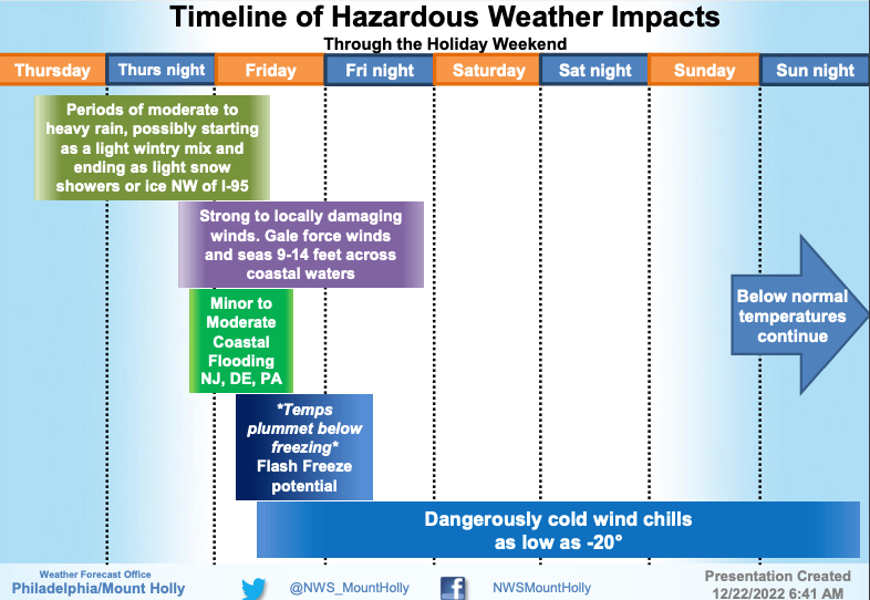
Precipitation — primarily heavy rain — will fall Thursday through Friday in the state, forecasters say. The rapid drop in temperatures, which will begin Friday, may give the region its coldest Christmas in decades, according to AccuWeather.
Here's what to know.
Rain, Floods
Weather officials expect 1-3 inches of rain to fall throughout the state, with the greatest totals near and north of Interstate 78. The National Weather Service also anticipates minor-to-moderate coastal flooding from Friday morning's and afternoon's high-tide cycles.
The threat of some form of flooding is widespread. Nearly all of New Jersey is under a flood watch from rainfall, a coastal flood watch or a coastal flood advisory:
- Flood watch, southwestern New Jersey, 1 p.m. Thursday through Friday morning: Salem, Gloucester, Camden, northwestern Burlington Counties. Flooding from heavy rainfall is possible, especially around bodies of water, urban areas and poor-drainage settings.
- Flood watch, North and Central Jersey, Thursday evening through Friday evening: Sussex, Warren, Morris, Hunterdon, Somerset, Middlesex, Mercer and western Monmouth Counties. Same threats as southwestern New Jersey's flood watch, with heavy rainfall expected, but during a different timeframe.
- Coastal flood warning, northern coastline, 4 a.m. to noon Friday: Middlesex and Monmouth Counties. Forecasters expect 1-2 feet of inundation above ground levels in low-lying areas near shorelines and tidal waterways. At this level, flooding may become severe enough to cause structural damage, along with widespread roadway flooding.
- Coastal flood advisories, most of New Jersey's coastline, 4 a.m. to noon Friday: Ocean, Atlantic, Cape May, southeastern Burlington and Cumberland Counties. Forecasters expect up to a foot of inundation above ground level in low-lying areas near shorelines and tidal waterways. This could lead to road closures.
'Rapid Freeze,' Ice, Snow
Once the cold front sweeps in, temperatures could fall from the mid-to-upper 50s Friday morning, to the 20s or lower Friday evening, weather officials say. The cold front will bring powerful gusts, and mid-Atlantic roads may freeze up starting Friday afternoon, according to AccuWeather.
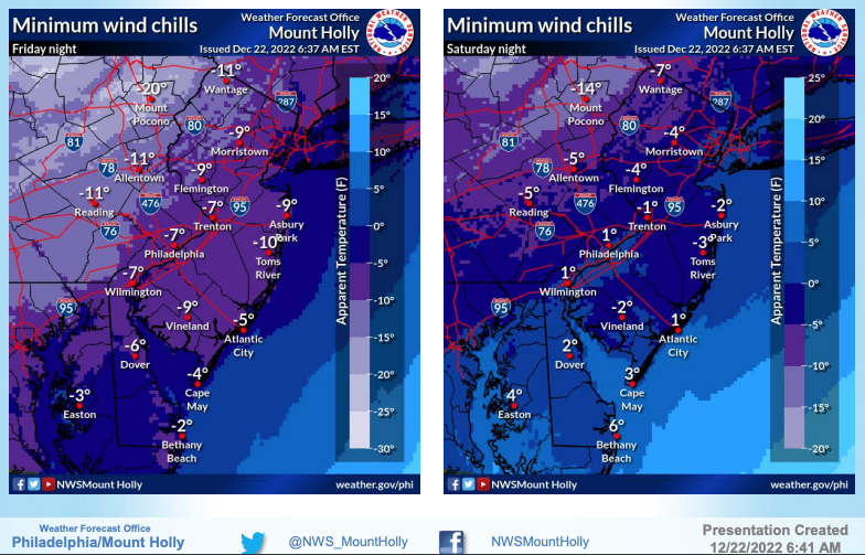
Temperatures could get "dangerously cold" Friday night through Saturday night — as low as -10 in parts of the state, per the National Weather Service.
Weather officials expect widespread gusts of 40-50 mph throughout Friday, with brief gusts of 60 mph possible.
"It is possible that some neighborhoods may face extended power outages through the Christmas weekend," AccuWeather says, "and some homes could lose their primary source of heat, as crews may struggle to restore all downed power lines in a timely manner due to the anticipated extreme conditions."
The rapid drop in temperature could create black ice. There's also a slight chance of spotty, light snow accumulation behind the cold front — particularly from Friday afternoon and early evening in northeastern New Jersey, the National Weather Service says.
Here's the National Weather Service's latest North Jersey forecast:
- Thursday: Rain, mainly after 1 p.m. High near 51. Northeast wind 8 to 11 mph, with gusts as high as 24 mph. Chance of precipitation is 100 percent. New precipitation amounts between a quarter and half of an inch possible.
- Thursday night: Rain before 1 a.m., then rain and possibly a thunderstorm between 1 a.m. and 4 a.m., then rain likely after 4 a.m. Some of the storms could produce heavy rainfall. Temperature rising to around 55 by 4 a.m. Breezy, with an east wind 21 to 24 mph becoming southeast after midnight. Winds could gust as high as 46 mph. Chance of precipitation is 100 percent. New rainfall amounts between 1 and 2 inches possible.
- Friday: Rain before 1 p.m., then a slight chance of snow showers. Some thunder is also possible. Temperature falling to around 22 by 5 p.m. Wind chill values between 5 and 15. Breezy, with a west wind 17 to 24 mph, with gusts as high as 46 mph. Chance of precipitation is 90 percent. Little or no snow accumulation expected.
- Friday night: Partly cloudy, with a low around 13. Wind chill values between -5 and 5. Breezy, with a west wind 17 to 22 mph, with gusts as high as 38 mph.
- Saturday: Mostly sunny, with a high near 22. Breezy, with a west wind 15 to 20 mph, with gusts as high as 30 mph.
- Saturday night: Mostly clear, with a low around 15.
- Sunday (Christmas): Sunny, with a high near 27.
- Sunday night: Mostly clear, with a low around 17.
- Monday: Sunny, with a high near 30.
Here's the agency's latest South Jersey forecast:
- Thursday: Rain, mainly after noon. High near 52. Breezy, with an east wind 15 to 20 mph, with gusts as high as 30 mph. Chance of precipitation is 90 percent. New precipitation amounts between a quarter and half of an inch possible.
- Thursday night: Rain, mainly before 3 a.m. Low around 47. Breezy, with an east wind 20 to 25 mph becoming south after midnight. Winds could gust as high as 45 mph. Chance of precipitation is 100 percent. New precipitation amounts between a half and three-quarters of an inch possible.
- Friday: Rain before 1 p.m., then a slight chance of snow. Temperature falling to around 25 by 5 p.m. Windy, with a west wind 25 to 35 mph, with gusts as high as 50 mph. Chance of precipitation is 80 percent. Little or no snow accumulation expected.
- Friday night: Mostly cloudy, with a low around 13. Wind chill values as low as -5. Windy, with a west wind 25 to 30 mph.
- Saturday: Partly sunny, with a high near 23. Breezy, with a west wind 20 to 25 mph.
- Saturday night: Partly cloudy, with a low around 17. Breezy.
- Sunday (Christmas): Mostly sunny, with a high near 27. Breezy.
- Sunday night: Partly cloudy, with a low around 17. Breezy.
- Monday: Mostly sunny, with a high near 30.
Get more local news delivered straight to your inbox. Sign up for free Patch newsletters and alerts.