Weather
Harsh Winter For NJ? Here's What 5 Major Forecasters Predict
South Jersey got pummeled last winter, while much of the state got off easy. Here's how forecasters expect the upcoming season to shape up.


NEW JERSEY — Last winter brought unusual patterns to New Jersey, with greater snowfall in the south than in much of the state's northern region. And even though Halloween just passed, it's not too early to begin thinking about the colder season.
The average winter in the Garden State (from 1991-2020) has brought 34.6 inches of snow to North Jersey, 28.3 inches to the central region and 18.6 inches to South Jersey. Last year, central and northeast New Jersey fell below expectations, while the northwest and southern Jersey Shore got plenty of snow.

Here's how major forecasters expect this winter to shape up.
Find out what's happening in Across New Jerseyfor free with the latest updates from Patch.
AccuWeather
Seasonal snowfall will likely fall below average in much of the mid-Atlantic region, according to AccuWeather's seasonal forecast. But precipitation could end up above-normal, with a few rain events likely throughout the winter.
Find out what's happening in Across New Jerseyfor free with the latest updates from Patch.
Both New York and Philadelphia will likely fall below their respective winter snowfall averages of 29.8 and 23.1 inches, according to AccuWeather. The service's forecasters predict 18-23 inches in New York, with 6-9 days of accumulation. For Philadelphia, AccuWeather expects 14-20 inches of snow throughout 5-7 days of accumulation.
Granted, snowfall significantly varied throughout South Jersey last year. Areas closer to Philadelphia received about 16 inches of snow, while the southern Jersey Shore got 2-3 feet.
But overall, AccuWeather predicts New Jersey's seasonal snowfall will be 50-74 percent below average.
Climate Prediction Center
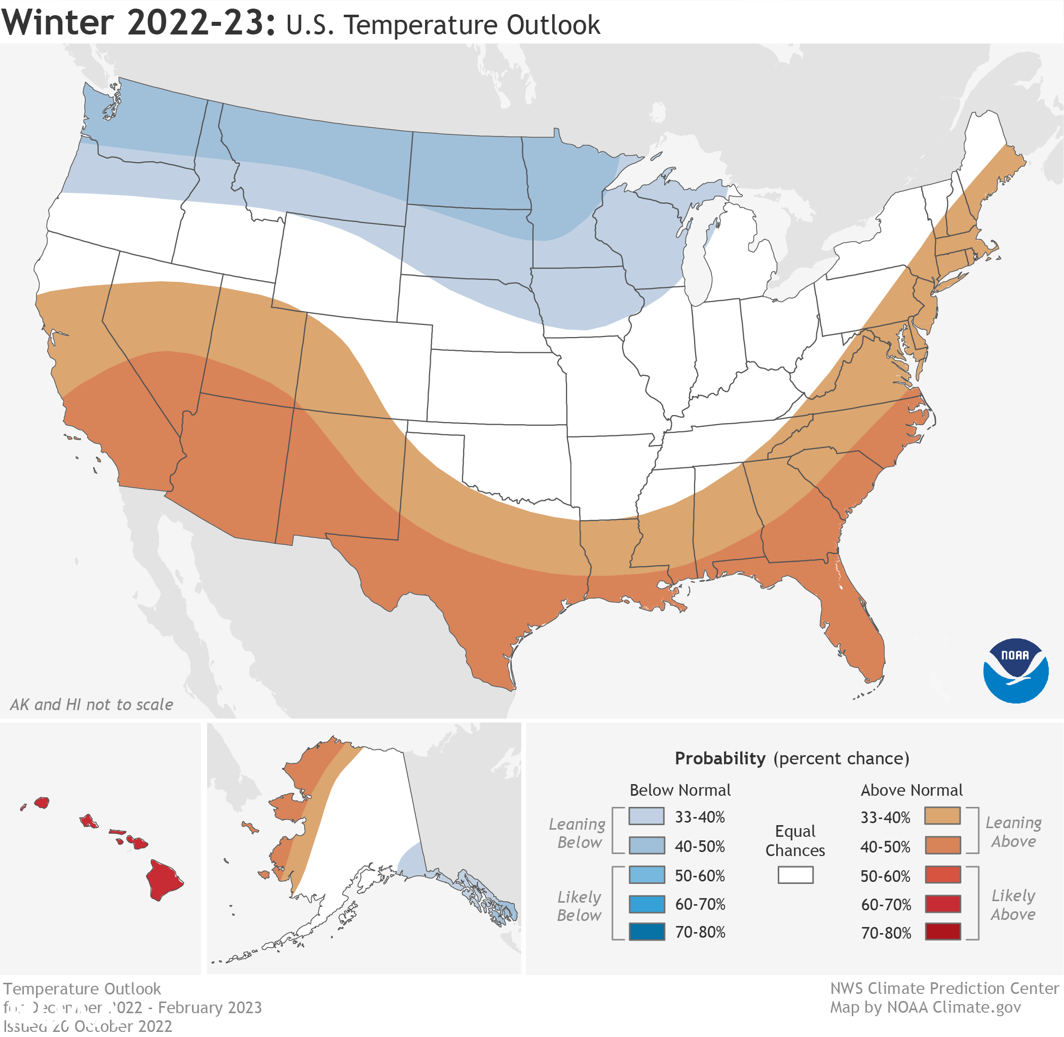
La Niña will return for the third-straight winter, driving warmer-than-average temperatures along the eastern seaboard. There's a decent probability — a 31-40 percent chance — that New Jersey's winter is warmer winter than usual, according to the National Oceanic and Atmospheric Administration's Climate Prediction Center.
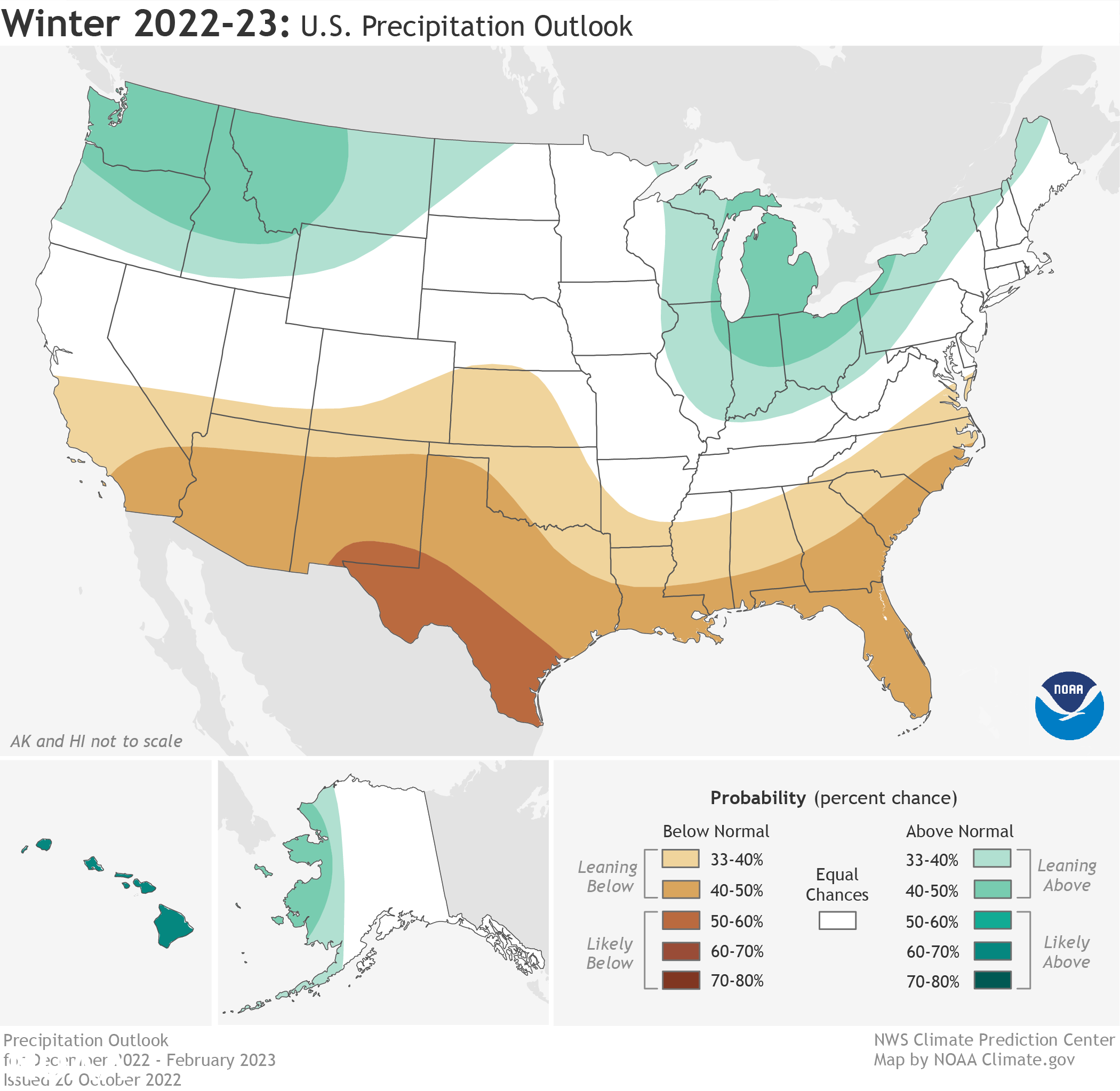
As far as whether precipitation totals fall higher or lower than the seasonal average, it's a tossup for New Jersey, according to the Climate Prediction Center.
Farmers' Almanac
While New Jersey sweltered in a summer heatwave, Farmers' Almanac released its early-August predictions for the winter. And the Farmers' Almanac says to get ready to shake, shiver and shovel.
The publication expects a stormy winter in the eastern half of the country. For some areas, that will mean heavy snow, while others may get more slush. In the Northeast, Farmers' Almanac anticipates "significant shivers" during a "slushy, icy, snowy" winter.
Old Farmers' Almanac
The Old Farmers' Almanac predicts that winter could get pretty harsh, with temperatures below normal and precipitation and snowfall above average along the Atlantic Corridor.
Early December, early and late January, and most of February will be the coldest periods, according to the Old Farmers' Almanac. The snowiest periods will occur throughout January and then late February, the publication predicts.
NY NJ PA Weather
The local weather outlet forecasts more snow as well, with 25 inches or more predicted. They're calling for slightly below-normal temperatures in the northern mid-Atlantic, with near-to-above-average snowfall.
"I expect a weather pattern that will be active and feature several phasing solutions between the Plains and the East coast where the Polar and Subtropical jet streams will interact," says the website's winter forecast. "The potential storm tracks will be dependent on the orientation of the trough around the Aleutian Islands to the Gulf of Alaska which is known as the EPO index."
Get more local news delivered straight to your inbox. Sign up for free Patch newsletters and alerts.