Weather
Heat Wave Hits NJ: How Hot Will It Get?
New Jersey is gearing up for its first heat wave of the year. Here's how hot it'll get, and how hot these days have been historically:

NEW JERSEY — Summer is hitting New Jersey head on, with the year's first heat wave hitting the state Monday.
A heat wave is defined in the northeast as at least three days with a high temperature of at least 90 degrees Fahrenheit. And according to forecasters, temperatures will often exceed that in most of the state.
In the Philadelphia area, this heat wave could last a full week, according to AccuWeather, whose forecasters warn of safety during this stretch.
Find out what's happening in Across New Jerseyfor free with the latest updates from Patch.
"The increased demand for cooling is going to be a problem here. This could have some impacts on the power grid," AccuWeather Chief Video Meteorologist Bernie Rayno said.
Temperatures could rise each day, according to the National Weather Service, and it'll be a dry week as well.
Find out what's happening in Across New Jerseyfor free with the latest updates from Patch.
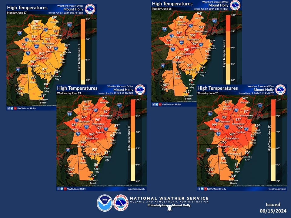
"High temperatures may touch the low 90s for Monday, but widespread highs in the 90s should be anticipated at this point for Tuesday, Wednesday, and Thursday," the National Weather Service said Friday.
On Wednesday and Thursdays, areas in North and Central Jersey could see temperatures of nearly 100 degrees. Areas at the shore tend to be slightly cooler, but some will still exceed the 90s by the end of the week.
So how hot is it going to get? The maps below show the daily high temperatures for Monday through Friday. Then, the chart shows the record hottest days for each area.

Get more local news delivered straight to your inbox. Sign up for free Patch newsletters and alerts.