Weather
Heavy Storms, Flooding Expected In NJ As Hurricane Debby Moves North
Hurricane Debby made landfall in Florida Monday. Here's how forecasters expect it to impact the Garden State:

NEW JERSEY — Another hot, humid and stormy week is in store for New Jersey as Hurricane Debby makes landfall in Florida and makes its way north.
The National Weather Service warns that this week will certainly be a busy one, weather-wise. The week starts off hot and humid, though remaining just below heat advisory territory.
Portions of North Jersey may see scattered thunderstorms Monday night, with the biggest threat being locally damaging downburst wind gusts, the National Weather Service said.
Find out what's happening in Across New Jerseyfor free with the latest updates from Patch.
Debby is supposed to downgrade into a Tropical Storm Monday night and "meander over the Southeast most of the week," with direct impacts on the Mid-Atlantic possible by the end of the week, the National Weather Service said.
RELATED: Hurricane Debby Makes Landfall As Category 1 Storm In FL’s Big Bend
Find out what's happening in Across New Jerseyfor free with the latest updates from Patch.
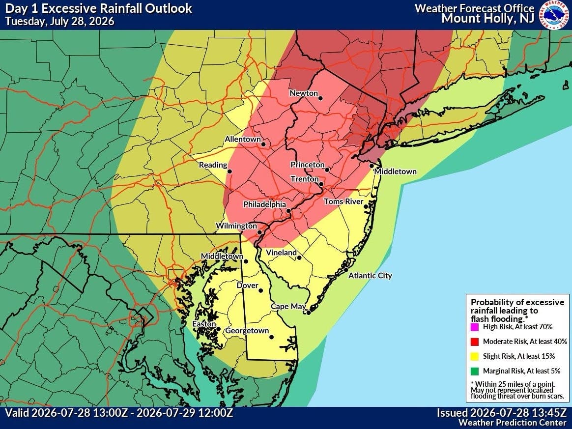
Tuesday afternoon through Wednesday morning will see showers and thunderstorms with heavy downpours, according to the forecast. One to two inches of rainfall is expected with locally higher amounts possible as atmospheric pressure mingles with the tropical moisture from Debby.
It's also likely to cause localized flash flooding, especially in urban areas. There's a risk for this statewide but most likely in Central Jersey, where flash floods are expected to be "numerous." Strong wind gusts may bring down trees and power lines, forecasters warn. This risk is statewide.
A flood watch is in effect Tuesday afternoon through Wednesday morning in Camden, Ocean, Monmouth, Gloucester, Hunterdon, Mercer, Burlington, Salem and Somerset counties.
However, the rest of the week's forecast is still unclear as of Monday, thanks to the uncertainty with Debby's evolution and track.
"A better indication on specific impacts and the evolution of Debby is likely to occur over the next several days once more information becomes available," the National Weather Service said.
Here's the latest forecast:
North Jersey
Monday: A 20 percent chance of showers and thunderstorms after 2pm. Sunny, with a high near 91. Calm wind becoming southwest 5 to 8 mph in the afternoon.
Monday Night: A slight chance of showers and thunderstorms before 8pm, then a slight chance of showers and thunderstorms after 2am. Partly cloudy, with a low around 75. Southwest wind around 6 mph. Chance of precipitation is 20%.
Tuesday: A chance of showers and thunderstorms, then showers likely and possibly a thunderstorm after 2pm. Mostly cloudy, with a high near 85. North wind around 6 mph. Chance of precipitation is 70%. New rainfall amounts between a quarter and half of an inch possible.
Tuesday Night: Showers likely and possibly a thunderstorm. Cloudy, with a low around 67. East wind 5 to 7 mph. Chance of precipitation is 70%. New rainfall amounts between three quarters and one inch possible.
Wednesday: Showers likely and possibly a thunderstorm before 2pm, then a chance of showers. Mostly cloudy, with a high near 76. Northeast wind around 10 mph. Chance of precipitation is 60%. New rainfall amounts between a quarter and half of an inch possible.
Wednesday Night: A 30 percent chance of showers before 2am. Mostly cloudy, with a low around 66.
Thursday: A 40 percent chance of showers after 8am. Partly sunny, with a high near 77.
Thursday Night: A chance of showers and thunderstorms, then showers likely and possibly a thunderstorm after 2am. Mostly cloudy, with a low around 68. Chance of precipitation is 60%.
Friday: Showers likely and possibly a thunderstorm. Mostly cloudy, with a high near 77. Chance of precipitation is 60%.
Central Jersey
Monday: Sunny, with a high near 92. Calm wind becoming southwest around 5 mph in the afternoon.
Monday Night: Mostly clear, with a low around 74. Southwest wind around 5 mph.
Tuesday: A chance of showers before 11am, then a chance of showers and thunderstorms between 11am and 2pm, then showers likely and possibly a thunderstorm after 2pm. Some of the storms could produce heavy rainfall. Partly sunny, with a high near 88. South wind around 5 mph. Chance of precipitation is 60%. New rainfall amounts between a quarter and half of an inch possible.
Tuesday Night: Showers and possibly a thunderstorm. Some of the storms could produce heavy rainfall. Patchy fog. Low around 67. East wind around 5 mph. Chance of precipitation is 80%. New rainfall amounts between 1 and 2 inches possible.
Wednesday: Showers likely and possibly a thunderstorm before 2pm, then a chance of showers and thunderstorms after 2pm. Some of the storms could produce heavy rainfall. Mostly cloudy, with a high near 77. Northeast wind around 10 mph. Chance of precipitation is 60%. New rainfall amounts between a quarter and half of an inch possible.
Wednesday Night: A chance of showers and thunderstorms. Mostly cloudy, with a low around 64. Chance of precipitation is 30%. New rainfall amounts between a tenth and quarter of an inch, except higher amounts possible in thunderstorms.
Thursday: Showers likely and possibly a thunderstorm, mainly after 2pm. Mostly cloudy, with a high near 76. Chance of precipitation is 60%.
Thursday Night: Showers likely and possibly a thunderstorm before 8pm, then a chance of showers and thunderstorms between 8pm and 2am, then showers likely and possibly a thunderstorm after 2am. Mostly cloudy, with a low around 66. Chance of precipitation is 70%.
Friday: Showers likely, with thunderstorms also possible after 2pm. Mostly cloudy, with a high near 79. Chance of precipitation is 70%.
South Jersey
Monday: Sunny, with a high near 90. Calm wind becoming southwest around 5 mph in the afternoon.
Monday Night: Mostly clear, with a low around 75. Southwest wind around 5 mph.
Tuesday: A slight chance of showers before 11am, then a chance of showers and thunderstorms between 11am and 5pm, then showers likely and possibly a thunderstorm after 5pm. Some of the storms could produce heavy rainfall. Increasing clouds, with a high near 89. Southwest wind 5 to 10 mph. Chance of precipitation is 60%. New rainfall amounts between a quarter and half of an inch possible.
Tuesday Night: Showers and thunderstorms likely, then showers and possibly a thunderstorm after 11pm. Some of the storms could produce heavy rainfall. Patchy fog. Low around 69. South wind around 5 mph. Chance of precipitation is 80%. New rainfall amounts between a quarter and half of an inch possible.
Wednesday: Showers likely and possibly a thunderstorm before 2pm, then a chance of showers and thunderstorms after 2pm. Some of the storms could produce heavy rainfall. Mostly cloudy, with a high near 78. Northeast wind around 5 mph. Chance of precipitation is 70%. New rainfall amounts between a half and three quarters of an inch possible.
Wednesday Night: A chance of showers and thunderstorms. Mostly cloudy, with a low around 65. Chance of precipitation is 50%. New rainfall amounts between a tenth and quarter of an inch, except higher amounts possible in thunderstorms.
Thursday: A chance of showers, then showers likely and possibly a thunderstorm after 2pm. Mostly cloudy, with a high near 77. Chance of precipitation is 60%.
Thursday Night: Showers likely and possibly a thunderstorm before 8pm, then a chance of showers and thunderstorms between 8pm and 2am, then showers likely and possibly a thunderstorm after 2am. Mostly cloudy, with a low around 68. Chance of precipitation is 70%.
Friday: Showers likely, with thunderstorms also possible after 2pm. Mostly cloudy, with a high near 80. Chance of precipitation is 70%.
Get more local news delivered straight to your inbox. Sign up for free Patch newsletters and alerts.