Weather
Winter Storm Approaches NJ: New Forecast Released
The potential storm could mark the first significant snowfall in New Jersey in more than two years.

NEW JERSEY — A winter storm with the potential for significant impacts continues to make its way to New Jersey, bringing the first chance for accumulating snow this season.
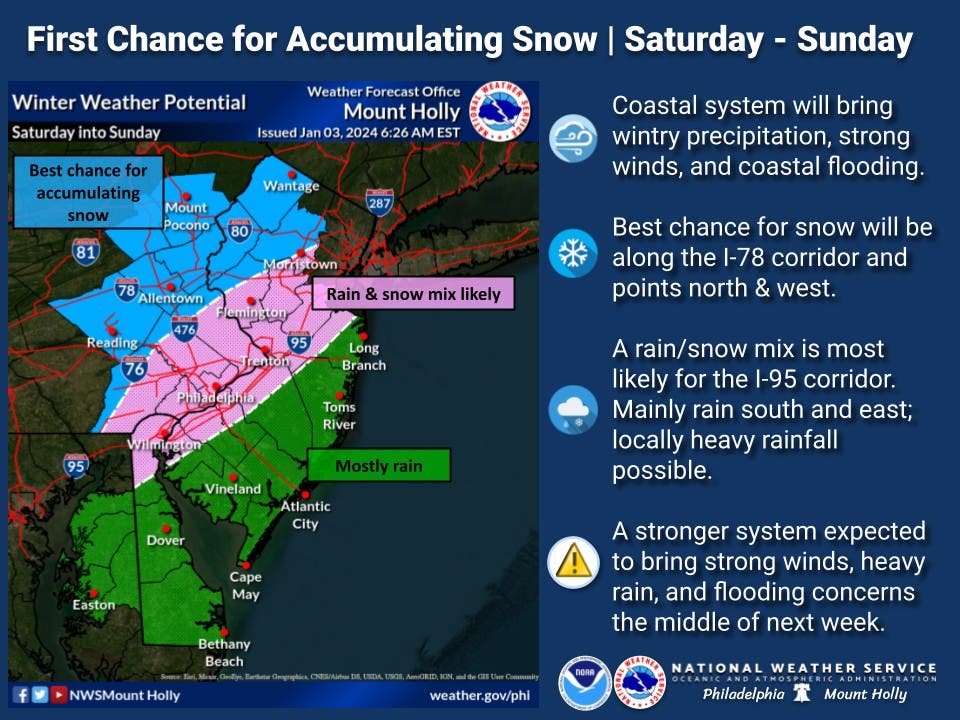
In a new forecast released Wednesday, the National Weather Service predicts those along and north of the I-78 corridor have the best chance of seeing snow this weekend. The rest of the state is more likely to see a snow mix or rain, the new forecast predicts.
"The I-95 corridor, however, will likely get stuck with a rain/snow mix with areas south and east seeing mostly rain. There still remains quite a bit of uncertainty with this storm, but we will have more details in the coming days," information from the National Weather Service Philadelphia/Mount Holly said.
Find out what's happening in Across New Jerseyfor free with the latest updates from Patch.
The cross-country storm will bring rain and snow to the West Coast mid-week before intensifying on the East Coast later this week.
AccuWeather meteorologists say they anticipate major travel disruptions on the roads and at the airports from the storm in the Northeast. "The anticipated timing of the storm may allow for better travel on Friday night and Saturday morning, as opposed to Sunday," AccuWeather said.
Find out what's happening in Across New Jerseyfor free with the latest updates from Patch.
It's still too early to know who will see snow, but forecasters say there is a potential for some areas to get more than 6 inches depending on the track and strength of the storm.
"The effects of the warmer ocean water could help contribute to a sharp variation in snowfall totals as you go from places like Central Park in New York City and Center City Philadelphia outward towards the suburbs," AccuWeather Senior Meteorologist Courtney Travis said.
Should anywhere near that snow total fall in the region, it would mark the first accumulating snowfall of that magnitude in two winters.
AccuWeather says this could be the "first widespread significant winter storm of the season and maybe years" for many in the northeast. As of New Year's Day, it has been 683 days since the New York City area received at least 1 inch of snowfall — which was on Feb. 16, 2022.
As forecasters continue to follow the weekend storm, the National Weather Service is warning about another system that is expected to arrive in the middle of next week.
That storm "could bring widespread heavy rain and flooding concerns once again," NWS forecasters said.
For now, here's a look at the upcoming forecast:
North Jersey
Wednesday: Mostly sunny, with a high near 41. West wind 5 to 10 mph.
Wednesday Night: Increasing clouds, with a low around 30. West wind around 5 mph.
Thursday: A slight chance of snow showers, mixing with rain after 11am, then gradually ending. Partly sunny, with a high near 40. Northwest wind 5 to 10 mph increasing to 10 to 15 mph in the afternoon. Winds could gust as high as 30 mph. Chance of precipitation is 20 percent.
Thursday Night: Mostly clear, with a low around 21. Northwest wind 10 to 15 mph, with gusts as high as 30 mph.
Friday: Sunny, with a high near 35. Northwest wind around 10 mph.
Friday Night: Mostly cloudy, with a low around 23.
Saturday: Snow likely after 1 p.m. Mostly cloudy, with a high near 36. Chance of precipitation is 60 percent.
Saturday Night: Snow. Low around 29. Chance of precipitation is 90 percent.
Sunday: A chance of snow. Mostly cloudy, with a high near 38. Chance of precipitation is 40 percent.
Sunday Night: Mostly cloudy, with a low around 27.
Central Jersey
Wednesday: Mostly sunny, with a high near 44. West wind 5 to 10 mph.
Wednesday Night: Increasing clouds, with a low around 30. West wind around 5 mph.
Thursday: A slight chance of rain and snow showers before 11 a.m., then a slight chance of rain showers between 11 a.m. and 2 p.m. Cloudy, then gradually becoming mostly sunny, with a high near 43. Northwest wind 5 to 10 mph increasing to 10 to 15 mph in the afternoon. Winds could gust as high as 25 mph. Chance of precipitation is 20 percent.
Thursday Night: Mostly clear, with a low around 22. Northwest wind 5 to 15 mph.
Friday: Sunny, with a high near 38. Northwest wind 5 to 10 mph.
Friday Night: Mostly cloudy, with a low around 23.
Saturday: Snow likely after 1 p.m. Cloudy, with a high near 39. Chance of precipitation is 70 percent.
Saturday Night: Rain and snow. Low around 31. Blustery. Chance of precipitation is 90percent.
Sunday: A chance of rain and snow. Mostly cloudy, with a high near 39. Chance of precipitation is 40 percent.
Sunday Night: Mostly cloudy, with a low around 27.
South Jersey
Wednesday: Mostly sunny, with a high near 44. West wind around 10 mph.
Wednesday Night: A slight chance of flurries after 1 a.m. Cloudy, with a low around 31. West wind around 5 mph.
Thursday: A slight chance of flurries before noon, then a slight chance of rain showers between noon and 2pm. Cloudy, then gradually becoming mostly sunny, with a high near 43. Northwest wind 10 to 15 mph, with gusts as high as 30 mph. Chance of precipitation is 20 percent.
Thursday Night: Mostly clear, with a low around 21. Blustery, with a northwest wind 15 to 20 mph, with gusts as high as 30 mph.
Friday: Sunny, with a high near 38. Northwest wind around 10 mph.
Friday Night: Mostly cloudy, with a low around 23.
Saturday: Rain after 1 p.m. High near 46. Chance of precipitation is 80 percent.
Saturday Night: Rain, mainly before 1 a.m. Low around 33. Windy. Chance of precipitation is 90 percent.
Sunday: A chance of rain. Mostly cloudy, with a high near 43. Breezy. Chance of precipitation is 40 percent.
Sunday Night: Mostly cloudy, with a low around 28.
Get more local news delivered straight to your inbox. Sign up for free Patch newsletters and alerts.