Weather
Snow Squalls High Winds, Dangerous Cold Descends On NJ
Painfully cold temperatures, high winds, and snow will create a dangerous situation in the Garden State this weekend.

The coldest weekend of the winter will be hitting New Jersey this weekend with a combination of painfully cold temperatures, high winds, and snow.
"The combination of Arctic air and gusty winds could make it feel colder than any other point so far this winter for many in the region," said AccuWeather Chief Meteorologist Jon Porter on Friday.
An Arctic blast and deep freeze are set to hit New Jersey on Saturday, bringing "painfully cold" temperatures to the area.
Find out what's happening in Across New Jerseyfor free with the latest updates from Patch.
"The blast of Arctic air is coming directly from the frozen tundra north of Hudson Bay, Canada, and will bring dangerous conditions and yet another surge in energy demands to over 100 million utility customers in the northeastern part of the nation," according to Accuweather.
Temperatures are beginning to plummet and snow is already moving in on Friday night.
Find out what's happening in Across New Jerseyfor free with the latest updates from Patch.
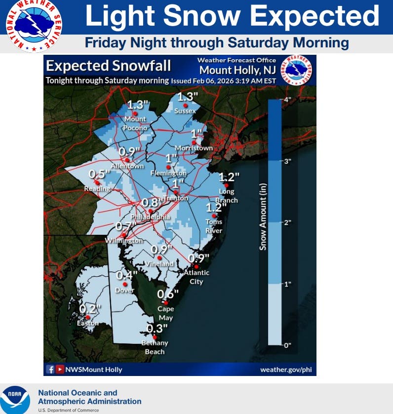
The cold front will bring some light snow overnight and some possible snow squalls on Saturday morning.
The majority of the state will see anywhere between a coating to an inch of snow. Some areas may see slightly more than an inch.
However, forecasters warn that the main issue will be the wind and dangerous cold in the wake of a cold front.
"Gusts of 40-60 mph are expected in the wake of the front, which will increase sharply late tonight," according to the US National Weather Service Philadelphia/Mount Holly.
Dangerously cold temperatures with wind chills of -10 to -20 degrees (and up to -30 degrees) are expected on Saturday night.
Wind chills are likely not to get above 0 degrees tomorrow during the day. An Extreme Cold Warning is in effect for the entire state.
Wind Advisories have also been issued for the entire state. The southern portion of the state and some of the coast also have High Wind Warnings, where they could see max wind gusts of 60mph.

Scattered power outages and tree damage are possible, according to the NWS.
Additionally, Storm Warnings, Gale Warnings, and Heavy Freezing Spray Warnings are in effect for Saturday and Saturday night for the boating community.
Northwest winds will increase to 30-40 kts, with gusts of 45-50 kts Saturday morning through Sunday morning. Moderate to heavy freezing spray is also expected.
"The combination of very cold air temperatures and strong winds will lead to very dangerous wind chills of -10° to -20°, with values as low as -25° expected across the Poconos Saturday through Sunday morning," according to the NWS.

Widespread sub-freezing temperatures are expected to persist through early next week.
"The longevity of these sub-freezing temperatures will continue to increase the risk of impacts, including to people and infrastructure," according to the NWS.
Here is a look at the forecast ahead:
North Jersey
Friday Night: Snow, mainly between 1 and 4 a.m. Low around 16. South wind 3 to 6 mph. Chance of precipitation is 80 percent. New snow accumulation of less than a half inch possible.
Saturday: A 40 percent chance of snow, mainly before 1 p.m. Cloudy and cold, with a temperature falling to around 11 by 5 p.m. Wind chill values between -10 and zero. Blustery, with a northwest wind 16 to 24 mph, with gusts as high as 49 mph.
Saturday Night: Mostly cloudy, then gradually becoming clear, with a low around 5. Wind chill values between -10 and -15. Blustery, with a northwest wind 16 to 23 mph, with gusts as high as 47 mph.
Sunday: Sunny and cold, with a high near 20. Northwest wind around 16 mph, with gusts as high as 30 mph.
Sunday Night: Mostly clear, with a low around 8.
Monday: Increasing clouds, with a high near 27.
Central Jersey
Friday Night: Snow likely, mainly between 1 and 3 a.m. Cloudy, with a low around 15. Calm wind becoming west around 5 mph after midnight. Chance of precipitation is 60 percent. New snow accumulation of 1 to 2 inches possible.
Saturday: A chance of snow before 7 a.m., then a slight chance of snow showers between 7 a.m. and 1 p.m. Mostly cloudy, with a temperature falling to around 10 by 5 p.m. Wind chill values as low as -9. Blustery, with a northwest wind 15 to 20 mph, with gusts as high as 45 mph. Chance of precipitation is 30 percent. New snow accumulation of less than a half inch possible.
Saturday Night: Mostly clear, with a low around 2. Wind chill values as low as -15. Northwest wind 10 to 15 mph, with gusts as high as 45 mph.
Sunday: Sunny, with a high near 20. Northwest wind 10 to 15 mph, with gusts as high as 30 mph.
Sunday Night: Mostly clear, with a low around 3.
Monday: Partly sunny, with a high near 27.
South Jersey
Friday Night: A chance of snow. Cloudy, with a low around 20. Calm wind becoming west around 5 mph after midnight. Chance of precipitation is 50 percent. New snow accumulation of less than one inch possible.
Saturday: A chance of snow showers, mainly before 1 p.m. Mostly cloudy, with a temperature falling to around 12 by 5 p.m. Wind chill values as low as -7. Blustery, with a northwest wind 15 to 20 mph, with gusts as high as 55 mph. Chance of precipitation is 40 percent. New snow accumulation of less than one inch possible.
Saturday Night: Partly cloudy, with a low around 3. Wind chill values as low as -13. Blustery, with a northwest wind 10 to 20 mph, with gusts as high as 50 mph.
Sunday: Sunny, with a high near 22. Northwest wind 10 to 15 mph, with gusts as high as 30 mph.
Sunday Night: Mostly clear, with a low around 7.
Monday: Mostly sunny, with a high near 28.
Get more local news delivered straight to your inbox. Sign up for free Patch newsletters and alerts.