Weather
NJ Weather: 60-MPH Wind Gusts, Hail Expected With Storm Front
Severe thunderstorms are possible late Thursday for parts of the state, as temperatures climb and a cold front approaches. See the latest:

NEW JERSEY — Wind gusts up to 60 miles per hour and hail are possible in New Jersey on Thursday as a line of powerful storms moves in from the Midwest.
Severe thunderstorms are possible late Thursday, according to the National Weather Service.
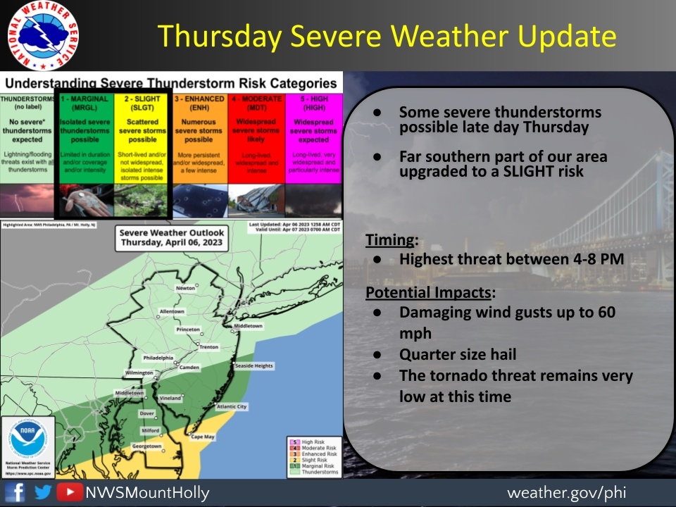
Southern NJ communities including Seaside Heights, Vineland, and Atlantic City are at a marginal risk for severe storms, according to the National Weather Service. Cape May has a slight risk, which is depicted in yellow in the above graphic.
Find out what's happening in Across New Jerseyfor free with the latest updates from Patch.
Temperatures will climb Thursday and a cold front will lift warm, moist air over the region. "Some ongoing thunderstorms will regain intensity," said AccuWeather forecasters in their latest update.
.jpg)
"Just enough warm air and moisture will be present ahead of an advancing cold front to trigger heavy, gusty and locally severe thunderstorms," AccuWeather Meteorologist Alyssa Smithmyer said. "The main threats from the storms on Thursday will be from wind and hail."
Find out what's happening in Across New Jerseyfor free with the latest updates from Patch.
The biggest threat of severe storms will be 4 and 8 p.m. Thursday, said National Weather Service forecasters. Damaging wind gusts up to 60 miles per hour and quarter-sized hail are possible with this system, and the tornado threat "remains very low" as of the NWS's Thursday morning update.
.jpg)
The front may "take its time" clearing the area into the evening, forecasters added.
Here's a look at Thursday's forecast around the state:
North Jersey
Today
A slight chance of showers before 2pm, then a chance of showers and thunderstorms between 2pm and 5pm, then showers likely and possibly a thunderstorm after 5pm. Some of the storms could produce gusty winds. Patchy fog before 10am. Otherwise, partly sunny, with a high near 84. Light and variable wind becoming west 5 to 9 mph in the morning. Winds could gust as high as 23 mph. Chance of precipitation is 60%.
Tonight
Showers and thunderstorms likely before 11pm, then a slight chance of showers between 11pm and 2am. Mostly cloudy, with a low around 46. Northwest wind 8 to 11 mph. Chance of precipitation is 60%. New precipitation amounts of less than a tenth of an inch, except higher amounts possible in thunderstorms.
Friday
Partly sunny, with a high near 60. Northwest wind 10 to 17 mph.
Central Jersey
Today
A chance of showers and thunderstorms between 2pm and 4pm, then showers likely and possibly a thunderstorm after 4pm. Partly sunny, with a high near 81. Northwest wind 5 to 10 mph becoming southwest in the morning. Winds could gust as high as 20 mph. Chance of precipitation is 60%. New rainfall amounts of less than a tenth of an inch, except higher amounts possible in thunderstorms.
Tonight
Showers and thunderstorms likely before 11pm, then a slight chance of showers between 11pm and 1am. Mostly cloudy, with a low around 46. Northwest wind around 10 mph, with gusts as high as 20 mph. Chance of precipitation is 60%. New precipitation amounts of less than a tenth of an inch, except higher amounts possible in thunderstorms.
Friday
Mostly cloudy, with a high near 59. Northwest wind 10 to 15 mph.
South Jersey
Today
A chance of showers and thunderstorms, mainly after 5pm. Partly sunny, with a high near 65. Southwest wind 10 to 15 mph. Chance of precipitation is 30%. New rainfall amounts between a tenth and quarter of an inch, except higher amounts possible in thunderstorms.
Tonight
Showers and thunderstorms, mainly before 3am, then a slight chance of thunderstorms after 5am. Some of the storms could produce small hail and gusty winds. Low around 48. West wind around 10 mph becoming north after midnight. Chance of precipitation is 80%. New rainfall amounts between a half and three quarters of an inch possible.
Get more local news delivered straight to your inbox. Sign up for free Patch newsletters and alerts.