Weather
Derecho Could Bring Thunderstorms, Severe Winds To NJ
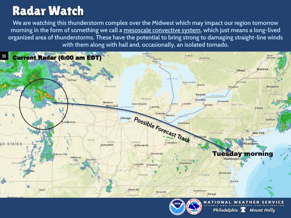
Tornado-producing storms in the Midwest will head toward the Mid-Atlantic, according to forecasters. But NJ could get lucky.

NEW JERSEY — Severe storms in the Midwest, which produced four reported tornadoes, will reach the Mid-Atlantic, according to forecasters. New Jersey could miss the worst of it, but the state may still get thunderstorms Monday night into Tuesday.
AccuWeather labeled the storm a derecho. Sometimes called an "inland hurricane," a derecho can cause significant damage and widespread power outages. The worst of the Midwest storms will miss New Jersey, with Washington, D.C. and Virginia sustaining the greatest impact on the East Coast, according to AccuWeather's forecasts.
But there's "some" chance that severe thunderstorms — which may produce 100 mph winds, hail and isolated tornadoes — could hit South Jersey overnight Monday, AccuWeather says.
Find out what's happening in Across New Jerseyfor free with the latest updates from Patch.
"Damaging storms at night can be particularly dangerous given many people are sleeping during that time and may miss notifications to shelter from harm," said AccuWeather Meteorologist Mary Gilbert.
There's also a chance Monday afternoon for isolated showers and thunderstorms in the Garden State. (See forecasts below.)
Find out what's happening in Across New Jerseyfor free with the latest updates from Patch.
As of Sunday, the federal Storm Prediction Center received more than 140 reports of severe weather, including four tornadoes in the central United States. Storms became especially intense in the Northern Plains, where softball-sized hail and 91 mph winds hit parts of South Dakota.
The National Weather Service continues to monitor the potential for severe thunderstorms Tuesday in the Mid-Atlantic.
"Derecho" refers to widespread, long-lasting, destructive straight-line winds. The term for the fast-moving winds was coined in 1888 to differentiate the weather pattern from that of tornadoes. To become a derecho, a storm must generate winds of at least 58 miles per hour along an area of 240 miles or more.
The potential for severe weather comes just days after a tornado formed in South Jersey. The National Weather Service confirmed a tornado, with estimated winds of up to 90 mph, hit Gloucester Township at about 5 a.m. Thursday. Read more: Tornado Touched Down In South Jersey Thursday Morning, Officials Say
Despite a mostly sunny forecast for New Jersey during the day Wednesday, showers could also run from Wednesday night into Friday. But so far, this weekend has a clear forecast.
Here's the National Weather Service's latest South Jersey forecast:
- Monday afternoon: A slight chance of showers and thunderstorms before 3 p.m. Partly sunny, with a high near 87. West wind 5 to 10 mph. Chance of precipitation is 20 percent.
- Monday night: Mostly cloudy, with a low around 67. West wind around 5 mph becoming calm in the evening.
- Tuesday: A chance of showers and thunderstorms, mainly before 1 p.m., then a slight chance of thunderstorms after 4 p.m. Some of the storms could produce small hail, gusty winds, and heavy rain. Mostly cloudy, with a high near 79. East wind around 5 mph. Chance of precipitation is 40 percent. New rainfall amounts between a tenth and quarter of an inch, except higher amounts possible in thunderstorms.
- Tuesday night: A slight chance of showers and thunderstorms between 7 p.m. and 8 p.m., then a slight chance of showers after 8 p.m. Partly cloudy, with a low around 62. Calm wind. Chance of precipitation is 20 percent.
- Wednesday: Sunny, with a high near 85. Northeast wind around 5 mph becoming southeast in the afternoon.
- Wednesday night: A chance of showers, mainly after 2 a.m. Partly cloudy, with a low around 64. Chance of precipitation is 30 percent. New precipitation amounts of less than a tenth of an inch possible.
- Thursday: A chance of showers. Partly sunny, with a high near 84. Chance of precipitation is 30 percent.
- Thursday night: A chance of showers before 8 p.m., then a chance of showers and thunderstorms between 8 p.m. and 2 a.m., then a chance of showers after 2 a.m. Mostly cloudy, with a low around 70. Chance of precipitation is 50 percent.
- Friday: A chance of showers. Mostly sunny, with a high near 90. Chance of precipitation is 40 percent.
- Friday night: Mostly clear, with a low around 64.
Here's the National Weather Service's latest North Jersey forecast:
- Monday afternoon: A 20 percent chance of showers and thunderstorms. Mostly cloudy, with a high near 91. West wind 3 to 8 mph.
- Monday night: Mostly cloudy, then gradually becoming mostly clear, with a low around 64. North wind 3 to 7 mph.
- Tuesday: A slight chance of showers between 11 a.m. and noon. Partly sunny, with a high near 82. Light and variable wind becoming north around 6 mph in the morning. Chance of precipitation is 20 percent.
- Tuesday night: Mostly clear, with a low around 66. Light and variable wind.
- Wednesday: Mostly sunny, with a high near 84. North wind 5 to 8 mph becoming southeast in the afternoon.
- Wednesday night: A 30 percent chance of showers after 3 a.m. Mostly cloudy, with a low around 66.
- Thursday: A 40 percent chance of showers. Mostly cloudy, with a high near 82.
- Thursday night: Showers likely, mainly after 9 p.m. Mostly cloudy, with a low around 71. Chance of precipitation is 60 percent.
- Friday: Showers likely, mainly before 9 a.m., then a chance of thunderstorms after 3 p.m. Mostly cloudy, with a high near 89. Chance of precipitation is 60 percent.
- Friday night: A chance of thunderstorms before 9 p.m. Partly cloudy, with a low around 67. Chance of precipitation is 40 percent.
Get more local news delivered straight to your inbox. Sign up for free Patch newsletters and alerts.