Weather
Snowfall Totals Rise For Weekend Storm: Latest Timeline For NJ Impacts
Forecasters have increased their snowfall predictions slightly for parts of the state as a weekend winter storm approaches.


NEW JERSEY — A winter storm expected to drop New Jersey's first significant snow in two years is just about here. Check out the latest timing and snowfall predictions:
A Winter Storm Watch has been issued by the National Weather Service(NWS) for counties along and above Route 80 as snowfall predictions have risen slightly to 8 to 12 inches. This includes Sussex, Passaic, Warren, and parts of Morris and Bergen Counties.
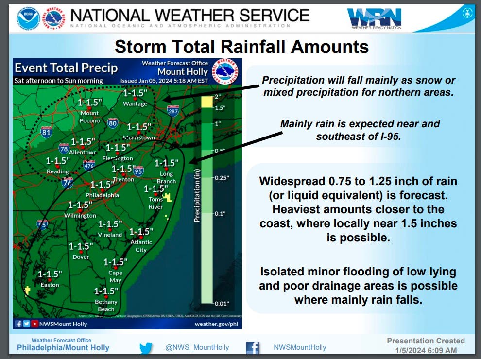
Central Jersey is expected to get about 1 to 2 inches of snow, while mainly rain is expected near and southeast of Interstate 95.
Find out what's happening in Across New Jerseyfor free with the latest updates from Patch.
Those predictions could change as there is a high probability of snowfall amounts exceeding it in Central and North Jersey, says NWS.

For areas receiving rain, there is a chance for isolated minor flooding of low-lying and poor drainage areas.
Find out what's happening in Across New Jerseyfor free with the latest updates from Patch.
"Minor coastal flooding possible with the Saturday night/Sunday morning high tide along portions of Atlantic coastal New Jersey and Delaware, and Delaware Bay," according to NWS.
The storm is expected to arrive around 1 p.m. in New Jersey. Gaining "strength and moisture from the Atlantic, it will begin to unload snow at a heavy and steady rate from northeastern Pennsylvania to the middle and lower part of the Hudson Valley to central and southern New England," according to AccuWeather.
"Hourly snowfall rates in this zone may exceed an inch per hour, which can overwhelm city and highway departments," according to AccuWeather.
Snow will continue to fall through Saturday night but the total might be reduced in Central Jersey where it may change to a mix of rain and sleet.
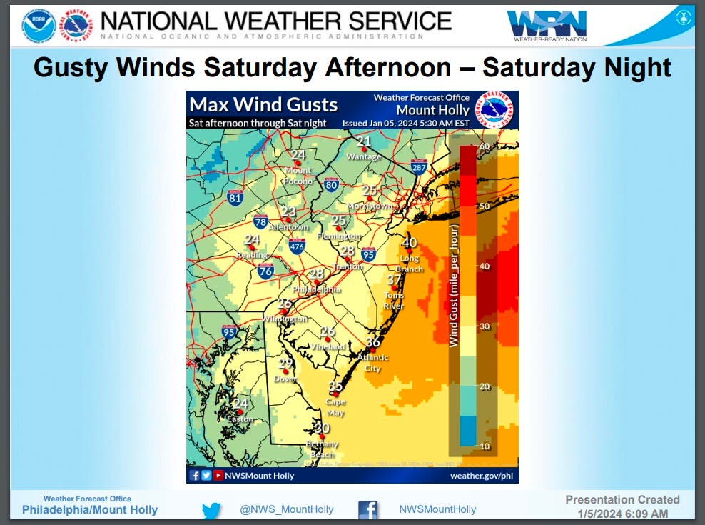
Gusty winds as high as 25 mph are also forecasted to arrive from Saturday afternoon through the night.
"Hazardous conditions Saturday night due to strong winds and dangerous seas. Gale force wind gusts and seas 6-10 feet possible," according to NWS.
Depending on your location, snow or a wintry mix will continue to fall on Sunday. A Winter Storm Watch for northern New Jersey will remain in effect through 6 p.m. on Sunday.
This storm will likely end New Jersey's almost two-year-long snow drought. As of New Year's Day, it has been 683 days since the New York City area received at least 1 inch of snowfall — which was on Feb. 16, 2022.
Regardless of what falls, motorists and travelers need to take extra care.
"Any accumulating snow can result in significant travel slowdowns, but this storm may have a greater impact than others of similar magnitude because it has been such a long time since more than 1 inch of snow has accumulated in these areas – it can take people a bit of time to once again get used to driving in and otherwise dealing with the snow," explained AccuWeather Chief Meteorologist Jon Porter. "This is typically experienced during the first snowstorm of a season, like this one, but is amplified since it’s the first storm in several years."
Looking ahead, another strong storm system is likely to impact the area from next week, from Tuesday through Wednesday. The storm could bring heavy rainfall with amounts of 2 to 3 inches that may lead to flooding. Strong damaging winds and significant coastal flooding are also possible.
The exact timing and details of next week's storm remain unclear at this time.
For now, let's take a look at the weekend weather ahead:
North Jersey
Friday: Sunny, with a high near 35. Northwest wind 5 to 10 mph.
Friday Night: Increasing clouds, with a low around 23. West wind around 5 mph.
Saturday: Snow likely, mainly after 5 p.m. Cloudy, with a high near 35. Light southeast wind becoming east 5 to 10 mph in the morning. Chance of precipitation is 60 percent. New snow accumulation of 1 to 2 inches possible.
Saturday Night: Snow before 11 p.m., then snow, possibly mixed with rain between 11pm and 2am, then snow after 2 a.m. The snow could be heavy at times. Low around 29. Northeast wind 10 to 15 mph. Chance of precipitation is 100 percent. New snow accumulation of 5 to 9 inches possible.
Sunday: Snow likely, mainly before 2 p.m. Cloudy, with a high near 35. Northeast wind 10 to 15 mph. Chance of precipitation is 70 percent. New snow accumulation of 2 to 4 inches possible.
Sunday Night: A slight chance of snow before 8 p.m. Mostly cloudy, with a low around 26. Chance of precipitation is 20 percent.
Central Jersey
Friday: Sunny, with a high near 38. Northwest wind 5 to 10 mph.
Friday Night: Increasing clouds, with a low around 23. Southwest wind around 5 mph becoming calm in the evening.
Saturday: Rain and snow, mainly after 1pm. High near 38. Light northeast wind becoming east 5 to 10 mph in the morning. Chance of precipitation is 80 percent. New snow accumulation of less than a half inch possible.
Saturday Night: Rain, possibly mixed with snow. Low around 32. Northeast wind around 15 mph, with gusts as high as 25 mph. Chance of precipitation is 100 percent. New snow accumulation of less than one inch possible.
Sunday: Rain and snow likely before 4 p.m., then a slight chance of snow. Cloudy, with a high near 37. North wind 10 to 15 mph becoming northwest in the afternoon. Chance of precipitation is 60 percent. New snow accumulation of less than a half inch possible.
Sunday Night: Mostly cloudy, with a low around 27.
South Jersey
Friday: Sunny, with a high near 38. Northwest wind 5 to 10 mph.
Friday Night: Increasing clouds, with a low around 26. West wind around 5 mph.
Saturday: Rain, mainly after 1 p.m. High near 44. South wind 5 to 10 mph becoming east 10 to 15 mph in the afternoon. Chance of precipitation is 90 percent. New precipitation amounts between a quarter and half of an inch possible.
Saturday Night: Rain. Low around 39. Breezy, with an east wind 20 to 25 mph, with gusts as high as 35 mph. Chance of precipitation is 100 percent. New precipitation amounts between three quarters and one inch possible.
Sunday: Rain likely, mainly before 10am. Cloudy, with a high near 43. Breezy, with a north wind 15 to 20 mph becoming northwest in the afternoon. Chance of precipitation is 60 percent. New precipitation amounts between a tenth and quarter of an inch possible.
Sunday Night: Mostly cloudy, with a low around 30.
Get more local news delivered straight to your inbox. Sign up for free Patch newsletters and alerts.