Weather
Severe Storms Could Provide July 4th Fireworks In NJ: Latest Forecast
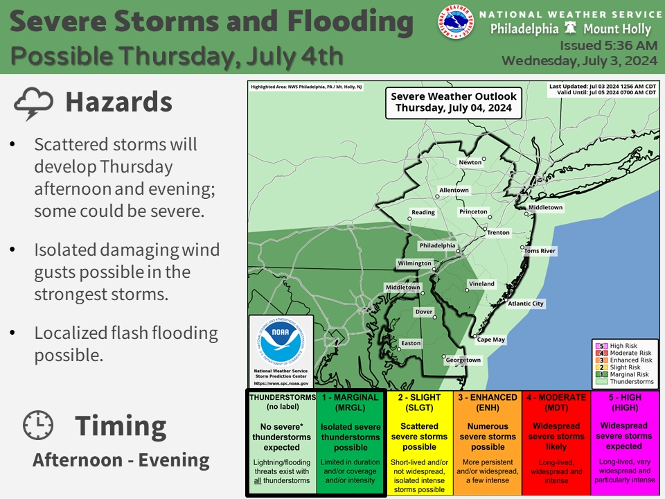
Forecasters warn that scattered storms could be severe with damaging winds and flash flooding in parts of NJ, interrupting holiday fun.

NEW JERSEY — Fireworks shows and other Independence Day festivities might have some issues this 4th of July as New Jersey is threatened by possible severe thunderstorms, according to the latest forecast.
"We certainly don't mean to rain on your parades, but there is a potential for scattered thunderstorms on the afternoon and evening of July 4th, some of which could become severe," the National Weather Service said.
The good news is that not all areas will see these severe storms. But those who did get storms will see heavy rain, possibly damaging winds and localized flash flooding, according to forecasters.
Find out what's happening in Across New Jerseyfor free with the latest updates from Patch.
A warm front could bring some isolated showers or storms into northwest New Jersey early Thursday morning, the National Weather Service said, but the greatest storm risk is in the afternoon and evening hours.
Before the storms hit, it'll be hot and humid statewide (except by the coast, which is always slightly cooler) with highs in the upper-80s to low-90s, and humidity will make it feel further into the 90s.
Find out what's happening in Across New Jerseyfor free with the latest updates from Patch.
Storms will move into North Jersey by the afternoon and then South and coastal Jersey by the evening, forecasters say.
"So it won't be an all day type rain event but unfortunately the timing won't be great as it could interfere with Independence Day festivities," the National Weather Service said.
Parts of South Jersey are at a marginal risk for severe storms. While the rest of the storms statewide aren't expected to be severe, they still carry the risk of lightning and flooding. Much of the state is also at a marginal risk for excessive rainfall.
"Storms may linger into a good portion of the evening Thursday before diminishing overnight," the National Weather Service said, ushering in a warm and muggy night followed by another hot and humid Friday.
It'll feel near 100 degrees Friday thanks to the humidity, and another round of storms is possible in the afternoon and evening, but likely not as widespread.
Here's the latest forecast.
North Jersey
Wednesday: Mostly sunny, with a high near 83. Light southwest wind becoming south 8 to 13 mph in the morning.
Wednesday Night: Partly cloudy, with a low around 69. Southwest wind 6 to 10 mph.
Independence Day: A 20 percent chance of showers and thunderstorms after 2 p.m. Partly sunny, with a high near 88. Southwest wind 6 to 9 mph, with gusts as high as 21 mph.
Thursday Night: A chance of showers and thunderstorms. Mostly cloudy, with a low around 74. South wind 5 to 7 mph becoming calm in the evening. Chance of precipitation is 50 percent.
Friday: A chance of showers, with thunderstorms also possible after 11 a.m. Mostly cloudy, with a high near 88. Calm wind becoming east 5 to 7 mph in the morning. Chance of precipitation is 30 percent.
Friday Night: A 50 percent chance of showers and thunderstorms. Mostly cloudy, with a low around 74.
Saturday: A chance of showers and thunderstorms, then showers likely and possibly a thunderstorm after 2 p.m. Mostly cloudy, with a high near 88. Chance of precipitation is 60 percent.
Saturday Night: Showers likely, mainly before 8 p.m. Mostly cloudy, with a low around 74. Chance of precipitation is 60 percent.
Sunday: Mostly sunny, with a high near 91.
Central Jersey
Wednesday: Mostly sunny, with a high near 85. South wind 5 to 10 mph.
Wednesday Night: Partly cloudy, with a low around 64. South wind 5 to 10 mph.
Independence Day: A chance of showers and thunderstorms after 2 p.m. Some of the storms could produce heavy rainfall. Partly sunny, with a high near 90. Southwest wind around 5 mph. Chance of precipitation is 30 percent. New rainfall amounts between a tenth and quarter of an inch, except higher amounts possible in thunderstorms.
Thursday Night: A chance of showers and thunderstorms. Some of the storms could produce heavy rainfall. Mostly cloudy, with a low around 70. South wind around 5 mph becoming calm in the evening. Chance of precipitation is 50 percent. New rainfall amounts between a tenth and quarter of an inch, except higher amounts possible in thunderstorms.
Friday: A chance of showers, with thunderstorms also possible after 11 a.m. Mostly cloudy, with a high near 88. Calm wind becoming south around 5 mph in the afternoon. Chance of precipitation is 30 percent. New rainfall amounts between a tenth and quarter of an inch, except higher amounts possible in thunderstorms.
Friday Night: A chance of showers and thunderstorms. Mostly cloudy, with a low around 71. Chance of precipitation is 40 percent. New rainfall amounts between a quarter and half of an inch possible.
Saturday: Showers and thunderstorms likely, mainly after 2 p.m. Mostly cloudy, with a high near 90. Chance of precipitation is 60 percent.
Saturday Night: Showers and thunderstorms likely before 2 a.m., then a chance of showers. Mostly cloudy, with a low around 71. Chance of precipitation is 60 percent.
Sunday: A chance of showers before 8 a.m. Mostly sunny, with a high near 89. Chance of precipitation is 30 percent.
South Jersey
Wednesday: Mostly sunny, with a high near 85. South wind 5 to 10 mph.
Wednesday Night: Partly cloudy, with a low around 64. South wind around 5 mph.
Independence Day: A slight chance of showers and thunderstorms after 2 p.m. Some of the storms could produce heavy rainfall. Partly sunny, with a high near 90. South wind 5 to 10 mph. Chance of precipitation is 20 percent.
Thursday Night: A chance of showers and thunderstorms, mainly after 8 p.m. Some of the storms could produce heavy rainfall. Mostly cloudy, with a low around 70. South wind around 5 mph becoming calm in the evening. Chance of precipitation is 50 percent. New rainfall amounts of less than a tenth of an inch, except higher amounts possible in thunderstorms.
Friday: A chance of showers and thunderstorms, mainly after 2 p.m. Mostly cloudy, with a high near 90. Calm wind becoming south around 5 mph in the afternoon. Chance of precipitation is 30 percent. New rainfall amounts of less than a tenth of an inch, except higher amounts possible in thunderstorms.
Friday Night: A chance of showers and thunderstorms. Mostly cloudy, with a low around 71. Chance of precipitation is 40 percent. New rainfall amounts between a tenth and quarter of an inch, except higher amounts possible in thunderstorms.
Saturday: A chance of showers and thunderstorms. Mostly cloudy, with a high near 91. Chance of precipitation is 50 percent.
Saturday Night: Showers and thunderstorms likely, mainly before 2 a.m. Mostly cloudy, with a low around 71. Chance of precipitation is 60 percent.
Sunday: A chance of showers and thunderstorms before 8 a.m. Mostly sunny, with a high near 90. Chance of precipitation is 30 percent.
Get more local news delivered straight to your inbox. Sign up for free Patch newsletters and alerts.