Weather
Severe Thunderstorms, Heavy Winds Could Hit NJ Wednesday: See Details
The high temperature may see shifts of around 30 degrees into the new week.

Winds of around 60 miles per hour could hit New Jersey from Wednesday afternoon into the evening as temperatures continue to climb higher into the 80's, the National Weather Service said.
South Jersey looks to get hit the hardest, but varying levels of storms can be anticipated statewide.
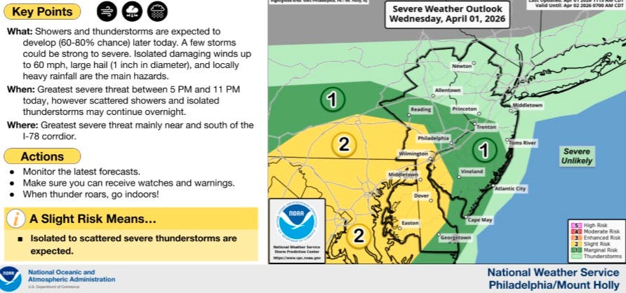
Large hail may fall during scattered showers and isolated storms that may continue into Thursday morning.
Find out what's happening in Across New Jerseyfor free with the latest updates from Patch.
As of 2:30 p.m., the latest radar showed little to no precipitation across the state, but things are anticipated to ramp up in the late afternoon and early evening hours.
The chance of rain looks to dip along with the temperatures on Thursday, and fall to a high of just 52.
Find out what's happening in Across New Jerseyfor free with the latest updates from Patch.
A small chance for storm showers then returns Thursday night into early Friday morning.
Temperatures will again rise close to a high of 80 degrees on Friday with light winds and a partly sunny outlook to the day.
Saturday looks to be bright and hot, with temperatures eclipsing 80 degrees.
Showers are likely to return on Sunday and pose a risk into early Monday morning.
The region is on track to see a drop of nearly 30 degrees over the two-day period between Saturday and Monday.
The week is set to begin with a high just short of 60 degrees that will linger through Tuesday.
MORE FROM PATCH: NJ Man Steals Tow Truck, Drives Into Oncoming Traffic, Injuring 3, Police Say
HAVE A STORY IDEA OR NEWS TO SHARE? Contact Editor Eddie Callahan at edward.callahan@patch.com to connect with Patch in your area.
Get more local news delivered straight to your inbox. Sign up for free Patch newsletters and alerts.