Weather
Another Windy Rain Storm Lands On NJ Weekend Forecast
Don't be fooled by milder weather in New Jersey. A "significant" storm approaching could slow some early holiday travelers.


NEW JERSEY — Don't be fooled by milder weather over the next couple of days: a strong storm system threatens to put a damper on New Jersey's weekend forecast.
Chilly, cold, dry yet sunny conditions are expected on Thursday with highs in the 40s. Then even milder weather returns on Friday with temperatures hitting highs in the 50s which continue into the weekend.
"A strong storm system however later Sunday and Monday brings rain and gusty winds," according to the National Weather Service.
Find out what's happening in Across New Jerseyfor free with the latest updates from Patch.
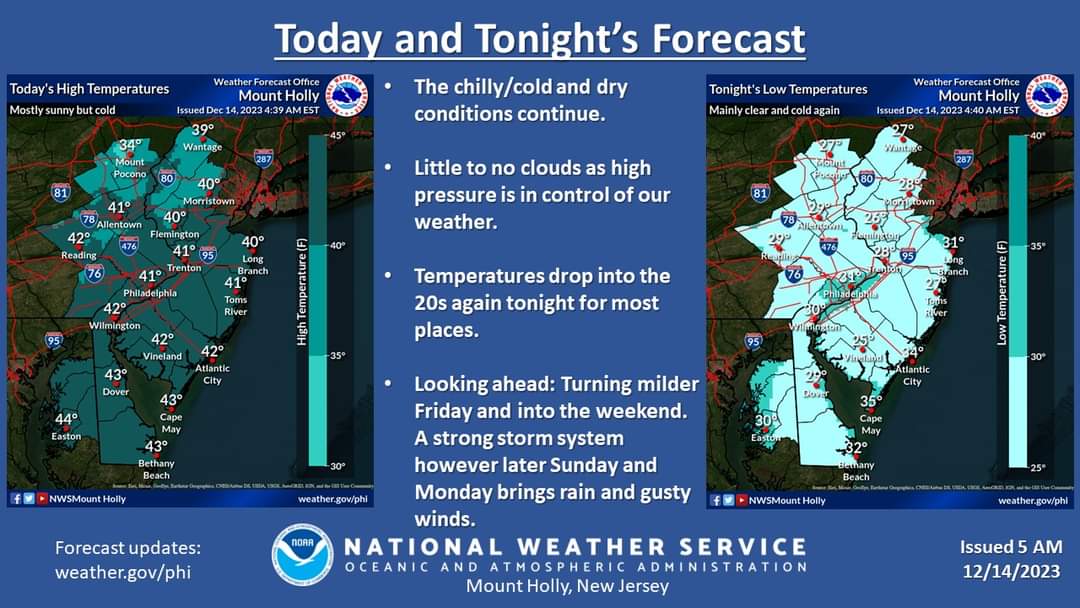
This "significant" storm could slow some early holiday travelers.
"The storm will evolve from a system moving from the Rockies to the South late this week, bringing snow, flooding downpours and coastal flooding. After gathering steam from the warm waters of the Gulf of Mexico early this weekend, the storm will rocket up the East Coast on Sunday and Monday along a path that is typical of storms during the winter months but carrying an amount of moisture usually seen during the summer," according to Accuweather.
Find out what's happening in Across New Jerseyfor free with the latest updates from Patch.
So when exactly will the storm hit New Jersey?
There is a chance for rain after 1 p.m. on Sunday but rain and gusty winds are more likely on Sunday night as there is a 70 to 80 percent chance of precipitation.
"While there remains some uncertainty in terms of the exact track and intensity of this storm, confidence is growing for a significant rain and wind event, especially from the Chesapeake Bay Area to most of southern New England," warned AccuWeather Senior Meteorologist Joe Lundberg.
If the storm wasn't bad enough, forecasters say there is a potential for it to become tropical despite the Atlantic hurricane season having ended.
"There is a slight chance the storm will acquire some tropical characteristics because of the time it spends over the warm waters of the Gulf of Mexico late this week," AccuWeather Director of Forecasting Operations Dan DePodwin said.
When the storm does arrive in New Jersey, rain is expected to be widespread and heavy at times, especially along the I-95 corridor.
Flooding is also possible due to the recent soaking we just received this past Sunday and Monday.
"Strong winds are likely with the storm, particularly near the coast, which can lead to beach erosion and coastal flooding," Lundberg said.
Here's a look at the forecast ahead:
North Jersey
Thursday: Sunny, with a high near 37. Northwest wind 5 to 10 mph.
Thursday Night: Mostly clear, with a low around 28. Southwest wind around 10 mph.
Friday: Sunny, with a high near 53. West wind 5 to 15 mph.
Friday Night: Mostly clear, with a low around 33. Northwest wind 5 to 10 mph.
Saturday: Mostly sunny, with a high near 50. Northwest wind 5 to 10 mph becoming northeast in the afternoon.
Saturday Night: Mostly cloudy, with a low around 35.
Sunday: Cloudy, with a high near 50.
Sunday Night: Rain likely. Cloudy, with a low around 44. Chance of precipitation is 70 percent.
Monday: Rain likely, mainly before 1pm. Mostly cloudy, with a high near 55. Chance of precipitation is 70 percent.
Monday Night: A chance of rain before 1 a.m., then a chance of rain and snow. Mostly cloudy, with a low around 31. Blustery. Chance of precipitation is 40 percent.
Central Jersey
Thursday: Sunny, with a high near 41. Northwest wind 5 to 10 mph.
Thursday Night: Mostly clear, with a low around 26. Southwest wind around 5 mph.
Friday: Sunny, with a high near 53. West wind around 10 mph, with gusts as high as 20 mph.
Friday Night: Mostly clear, with a low around 32. West wind 5 to 10 mph.
Saturday: Mostly sunny, with a high near 52. Northwest wind around 5 mph becoming northeast in the afternoon.
Saturday Night: Mostly cloudy, with a low around 36.
Sunday: A chance of rain after 1 p.m. Cloudy, with a high near 53. Chance of precipitation is 30 percent.
Sunday Night: Rain likely. Cloudy, with a low around 46. Chance of precipitation is 70 percent.
Monday: Rain, mainly before 1 p.m. High near 57. Chance of precipitation is 80 percent.
Monday Night: A chance of rain before 1 a.m. Mostly cloudy, with a low around 32. Breezy. Chance of precipitation is 30 percent.
South Jersey
Thursday: Sunny, with a high near 41. Northwest wind 5 to 10 mph.
Thursday Night: Mostly clear, with a low around 28. Southwest wind 5 to 10 mph.
Friday: Sunny, with a high near 52. West wind around 15 mph.
Friday Night: Mostly clear, with a low around 32. West wind around 10 mph.
Saturday: Mostly sunny, with a high near 52. Northwest wind 5 to 10 mph becoming northeast in the afternoon.
Saturday Night: Mostly cloudy, with a low around 38.
Sunday: A chance of rain after 1 p.m. Cloudy, with a high near 55. Chance of precipitation is 30 percent.
Sunday Night: Rain. Low around 49. Breezy. Chance of precipitation is 80 percent.
Monday: Rain. High near 57. Breezy. Chance of precipitation is 80 percent.
Monday Night: A chance of rain before 1 a.m. Mostly cloudy, with a low around 32. Breezy. Chance of precipitation is 40 percent.
Get more local news delivered straight to your inbox. Sign up for free Patch newsletters and alerts.