Weather
Snowfall Totals Increase Again Ahead Of NJ Storm: Latest Timeline
Some parts of New Jersey could see up to a foot of snow Saturday into Sunday, while other parts should expect sleet, rain and gusty winds.


NEW JERSEY — Up to a foot of snow is possible in some parts of New Jersey, forecasters said Saturday, as a winter storm bringing sleet, heavy rains and gusty winds takes aim at the state.
A winter storm warning is in effect starting at 1 p.m. Saturday for Sussex, Warren and Morris counties. The storm is expected to drop anywhere from 8 to 12 inches of snow on Sussex County, National Weather Service forecasters said — an increase from Friday's predictions.
Other counties included in the warning area will likely see snow totals ranging from 6 to 8 inches, forecasters said.
Find out what's happening in Across New Jerseyfor free with the latest updates from Patch.
"Snow totals have come up a bit in areas where snow is expected," the National Weather Service said in its forecast update early Saturday. "In the southern Poconos and northern New Jersey, up to a foot of snow is possible, especially at higher elevations."

According to forecasters, parts of New Jersey included in the winter storm warning could see an inch of snow per hour at times. Some sleet may also mix with the snow.
Find out what's happening in Across New Jerseyfor free with the latest updates from Patch.
Snow is expected to start Saturday afternoon before peaking during the evening hours and tapering off into Sunday morning.
Forecasters said around 3 to 6 inches of snow are expected along the Interstate 78 corridor and could change over to rain or sleet at times.
This storm will likely end New Jersey's almost two-year-long snow drought. As of New Year's Day, it has been 683 days since the New York City area received at least 1 inch of snowfall — which was on Feb. 16, 2022.
Areas southeast of Interstate 95 should expect mainly rain on Saturday, according to the NWS. Forecasters said rain will be widespread and up to 1.5 inches could fall in some areas, bringing with it the threat of flooding to low-lying and poor drainage areas.
As a result of the expected rain, minor coastal flooding is expected Saturday night through Sunday morning's high tide along the back bays of Barnegat Bay and the remainder of the New Jersey coast, according to the NWS.

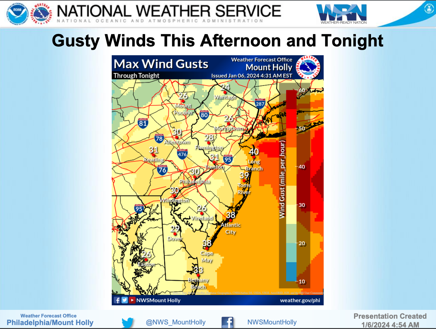
Windy conditions are also expected, according to forecasters. A small craft advisory remains in effect from 1-6 p.m. Saturday. A gale warning is also in effect from 6 p.m. Saturday until 6 a.m. Sunday.
"By late this afternoon, east winds will increase to 15 to 20 mph with 20 to 30 mph gusts, except for right along the coasts, where gusts up to 40 mph are possible," the National Weather Service said.
Looking ahead, another strong storm system is likely to impact the state from next week on Tuesday and Wednesday. The storm could bring 2 to 3 inches of rain with 4 inches possible, forecasters said. Strong, damaging winds and significant coastal flooding are also possible.
While the exact timing and details of next week's storm remain unclear, forecasters said the most significant impacts will likely occur Tuesday night.
Here's a look at this weekend's weather forecast:
North Jersey
Saturday: Snow likely, mainly after 5 p.m. Cloudy, with a high near 35. Wind chill values between 25 and 30. East wind 6 to 8 mph. Chance of precipitation is 60 percent. Total daytime snow accumulation of around an inch possible.
Saturday Night: Rain and snow before midnight, then snow between midnight and 1 a.m, then rain and snow likely after 1 a.m. Low around 32. Wind chill values between 25 and 30. East wind around 13 mph, with gusts as high as 24 mph. Chance of precipitation is 100 percent. New snow accumulation of 3 to 5 inches possible.
Sunday: Snow, mainly between 7 a.m. and 1 p.m. High near 33. North wind 6 to 10 mph. Chance of precipitation is 80 percent. New snow accumulation of less than one inch possible.
Sunday Night: Mostly cloudy, then gradually becoming mostly clear, with a low around 26. Wind chill values between 20 and 25. Northwest wind 5 to 8 mph.
Central Jersey
Saturday: Rain, possibly mixed with snow, becoming all rain after 4 p.m. High near 38. East wind 5 to 15 mph. Chance of precipitation is 100 percent. Total daytime snow accumulation of less than a half inch possible.
Saturday Night: Rain, mainly before 1 a.m. Low around 34. Breezy, with an east wind 15 to 20 mph becoming north 10 to 15 mph after midnight. Winds could gust as high as 35 mph. Chance of precipitation is 100 percent. New precipitation amounts between a half and three-quarters of an inch possible.
Sunday: Rain and snow likely before 2 p.m., then a slight chance of rain between 2 p.m. and 4 pm. Cloudy, with a high near 40. West wind 5 to 10 mph. Chance of precipitation is 60%. Little or no snow accumulation expected.
Sunday Night: Mostly cloudy, then gradually becoming mostly clear, with a low around 29. West wind 5 to 10 mph.
South Jersey
Saturday: Rain, mainly after 1 p.m. The rain could be heavy at times. High near 43. East wind 10 to 15 mph, with gusts as high as 30 mph. Chance of precipitation is 100%. New precipitation amounts between a half and three-quarters of an inch possible.
Saturday Night: Rain, mainly before midnight. The rain could be heavy at times. Low around 35. Breezy, with an east wind of 15 to 20 mph becoming northwest 10 to 15 mph after midnight. Winds could gust as high as 35 mph. Chance of precipitation is 100 percent. New precipitation amounts between a quarter and half of an inch possible.
Sunday: A chance of rain, mainly before 9 a.m. Mostly cloudy, with a high near 43. West wind 5 to 15 mph, with gusts as high as 25 mph. Chance of precipitation is 30%. New precipitation amounts of less than a tenth of an inch possible.
Sunday Night: Partly cloudy, with a low around 29. West wind around 10 mph, with gusts as high as 20 mph.
Get more local news delivered straight to your inbox. Sign up for free Patch newsletters and alerts.