Weather
Another Storm Headed To NJ Friday, Then Arctic Blast: Latest Details
The frigid cold temperatures may be so severe they could pose health risks to those exposed and freeze pipes in New Jersey.

NEW JERSEY — High winds and flooding rains are forecast to start the weekend before an "arctic blast" is projected to sweep into New Jersey. The frigid cold temperatures could pose health risks to those exposed and freeze pipes.
"It's the calm before the storm...," said the National Weather Service.
Clouds will begin to creep in throughout the day before rain is likely to fall before 10 p.m.
Find out what's happening in Across New Jerseyfor free with the latest updates from Patch.
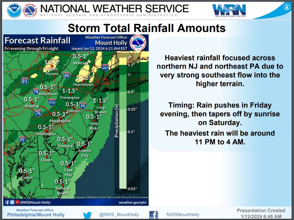
The heaviest rain will be around 11 p.m. to 4 a.m. There is also a possibility of a thunderstorm during this period.
The heaviest rainfall, dropping between 1 to 1.5 inches of rain, will be focused across northern and Central New Jersey and northeast Pennsylvania due to a very strong southeast flow into the higher terrain.
Find out what's happening in Across New Jerseyfor free with the latest updates from Patch.
"Normally, this type of rainfall would mainly result in little to minor flooding. However, with moderate to major river flooding continuing in portions of the Raritan and Passaic Basins into this weekend, this new rainfall will exacerbate river flooding," said NWS.
Additionally, soils remain very saturated which increases the likelihood that urban and small stream flooding is possible Friday night into early Saturday morning.
As a result, a Flood Watch has been issued to all counties in North and Central Jersey and some counties in the Southwest portion of the state.
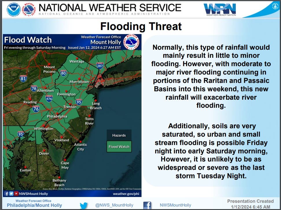
"However, it is unlikely to be as widespread or severe as the last storm Tuesday Night," said NWS.
Minor to moderate coastal flooding is also forecasted to begin as early as Friday night and continue through Saturday.
The storm will also bring some strong to damaging winds gusting up to 40 to 50 mph across the coastal plain up to the Interstate 95 corridor and 50 to 55 mph for coastal areas. Wind gusts of 35 to 45 mph are expected northwest of I-95.
Arctic Blast
As the rain storm passes through, forecasters already have their eye on some dangerously cold arctic air that could head to New Jersey early next week.
The cold blast is currently making its way "across western and central Canada and will soon sweep into the western and central United States later this week before reaching the East by midmonth. Energy demands will surge, and the cold may be so severe as to put those exposed at risk for serious health concerns, while frozen pipes may lead to extensive property damage," AccuWeather meteorologists warn.
The deep penetrating Arctic air brings the potential of snow and ice to the central and northeast parts of the country from Sunday night through Wednesday.
The threat for New Jersey is more likely from Monday night through Wednesday when the cold air mixed with our recent flooding could cause issues in the area.
"The eastward expansion of the Arctic air could make for a real mess where flood waters linger and then freeze. Similar problems could occur along some secondary roads where runoff continues in the wake of the big rain and wind storm from Friday to Saturday," according to AccuWeather.
While snow is possible in New Jersey, the amount will depend greatly on the track of the storm as it makes its way toward the Atlantic coast.
For now, here is a look at the upcoming forecast:
North Jersey
Friday: Increasing clouds, with a high near 43. North wind 5 to 10 mph becoming southeast in the afternoon.
Friday Night: A chance of rain and snow before 7 p.m., then rain. The rain could be heavy at times. Some thunder is also possible. Temperature rising to around 50 by 4 a.m. Breezy, with a southeast wind 15 to 25 mph, with gusts as high as 40 mph. Chance of precipitation is 100 percent. Little or no snow accumulation expected.
Saturday: A chance of rain, mainly before 11 a.m. Partly sunny, with a temperature falling to around 37 by 5 p.m. Breezy, with a west wind 10 to 20 mph, with gusts as high as 35 mph. Chance of precipitation is 40 percent. New precipitation amounts between a tenth and quarter of an inch possible.
Saturday Night: Partly cloudy, with a low around 28. Southwest wind around 15 mph, with gusts as high as 30 mph.
Sunday: A slight chance of snow before 1pm, then a chance of snow after 4 p.m. Mostly sunny, with a high near 35. Southwest wind 10 to 15 mph. Chance of precipitation is 30 percent. Little or no snow accumulation expected.
Sunday Night: A chance of snow before 7 p.m. Mostly clear, with a low around 17. Chance of precipitation is 30 percent.
M.L.King Day: Partly sunny, with a high near 28.
Monday Night: Mostly cloudy, with a low around 21.
Tuesday: Snow likely, mainly after 1pm. Cloudy, with a high near 31. Chance of precipitation is 60 percent.
Tuesday Night: A chance of snow before 1 a.m. Mostly cloudy, with a low around 16. Breezy. Chance of precipitation is 40 percent.
Wednesday: Mostly sunny, with a high near 24. Breezy.
Central Jersey
Friday: Increasing clouds, with a high near 46. Light and variable wind becoming east 5 to 10 mph in the afternoon.
Friday Night: Rain likely before 10 p.m., then rain and possibly a thunderstorm between 10 p.m. and 4 a.m., then rain after 4 a.m. Some of the storms could produce heavy rainfall. Temperature rising to around 54 by 4 a.m. Breezy, with an east wind 10 to 15 mph increasing to 20 to 25 mph. Winds could gust as high as 35 mph. Chance of precipitation is 100 percent. New rainfall amounts between 1 and 2 inches possible.
Saturday: A chance of rain, mainly before 11 a.m. Partly sunny, with a temperature falling to around 40 by 5 p.m. Breezy, with a west wind 10 to 15 mph increasing to 15 to 20 mph in the morning. Winds could gust as high as 35 mph. Chance of precipitation is 30 percent. New precipitation amounts between a tenth and quarter of an inch possible.
Saturday Night: Mostly clear, with a low around 29. Southwest wind around 15 mph, with gusts as high as 30 mph.
Sunday: A chance of snow after 4 p.m. Mostly sunny, with a high near 39. Southwest wind 10 to 15 mph, with gusts as high as 30 mph. Chance of precipitation is 30 percent. Little or no snow accumulation expected.
Sunday Night: A chance of snow before 7 p.m. Mostly clear, with a low around 19. Chance of precipitation is 30 percent.
M.L.King Day: Partly sunny, with a high near 30.
Monday Night: A chance of snow after 1 a.m. Mostly cloudy, with a low around 23. Chance of precipitation is 30 percent.
Tuesday: Snow likely. Cloudy, with a high near 34. Chance of precipitation is 60 percent.
Tuesday Night: A chance of snow before 1 a.m. Mostly cloudy, with a low around 17. Breezy. Chance of precipitation is 40 percent.
Wednesday: Mostly sunny, with a high near 26. Breezy.
South Jersey
Friday: Increasing clouds, with a high near 46. North wind 5 to 10 mph becoming southeast in the afternoon. Winds could gust as high as 20 mph.
Friday Night: Rain and possibly a thunderstorm. Some of the storms could produce heavy rainfall. Temperature rising to around 54 by 4 a.m. Windy, with a southeast wind 15 to 20 mph becoming southeast 25 to 30 mph after midnight. Winds could gust as high as 50 mph. Chance of precipitation is 100 percent. New rainfall amounts between a half and three-quarters of an inch possible.
Saturday: A chance of rain, mainly before 9 a.m. Mostly sunny, with a temperature falling to around 43 by 5 p.m. Breezy, with a west wind 15 to 20 mph, with gusts as high as 35 mph. Chance of precipitation is 30 percent. New precipitation amounts of less than a tenth of an inch possible.
Saturday Night: Mostly clear, with a low around 32. West wind around 15 mph, with gusts as high as 35 mph.
Sunday: A slight chance of snow after 4 p.m. Sunny, with a high near 44. Southwest wind 10 to 15 mph, with gusts as high as 25 mph. Chance of precipitation is 20 percent.
Sunday Night: Mostly clear, with a low around 21.
M.L.King Day: Partly sunny, with a high near 36.
Monday Night: A chance of snow after 1am. Mostly cloudy, with a low around 25. Chance of precipitation is 30 percent.
Tuesday: Snow likely. Cloudy, with a high near 39. Chance of precipitation is 70 percent.
Tuesday Night: A chance of snow before 1 a.m. Mostly cloudy, with a low around 16. Breezy. Chance of precipitation is 40 percent.
Wednesday: Mostly sunny, with a high near 28. Breezy.
Get more local news delivered straight to your inbox. Sign up for free Patch newsletters and alerts.