Weather
Tropical Threats Franklin, Idalia To Impact NJ This Week
While it's unlikely Franklin or Idalia will make landfall in New Jersey, forecasters say there could be impact to the region.


NEW JERSEY — Forecasters are watching two storms brewing in the Atlantic Ocean this week, and said Hurricane Franklin and Tropical Storm Idalia could impact New Jersey with high tides, strong offshore winds, and the potential for beach closures.
These strong tropical systems are not expected to make landfall in the Garden State, but their positions in the Atlantic Ocean could impact the region just days before the second anniversary of Tropical Depression Ida.
"The eastern U.S. will have some indirect impacts from Franklin this week as it churns well offshore," said AccuWeather.
Find out what's happening in Across New Jerseyfor free with the latest updates from Patch.
Beach-goers may have their plans later this week dampened, forecasters said. Rough surf and strong rip currents are expected along the Jersey Shore, and flooding will also be possible with rain expected on Tuesday and Wednesday.
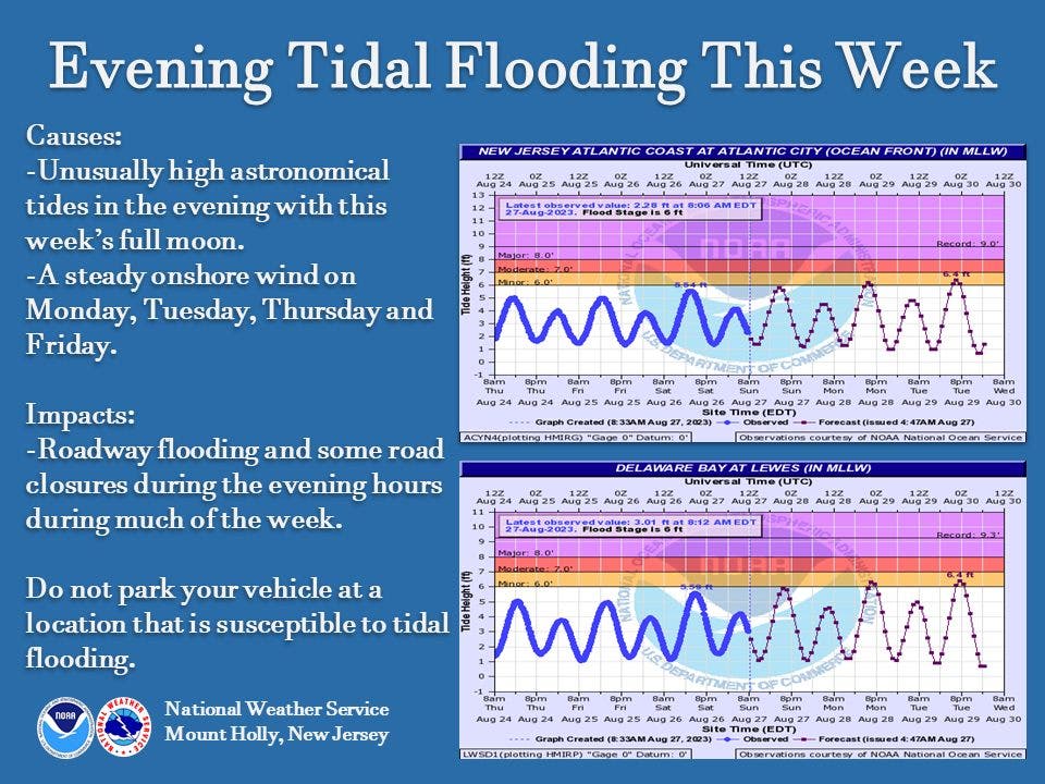
“Unusually high astronomical tides” are also possible along the Jersey Shore in the evening this week, with the full moon.
Find out what's happening in Across New Jerseyfor free with the latest updates from Patch.
And, a band of thunderstorms with "periods of heavy rain" are in store for the region from Monday night through early Wednesday, which may strengthen with the presence of tropical moisture, said the National Weather Service office in Mount Holly.
“It won’t be raining that entire time everywhere but there will be a threat of localized flooding, especially for areas near and south/east of the urban (I-95) corridor," NWS forecasters added. "In addition, some tidal flooding is likely the next few evenings and this could be exacerbated by any heavier rainfall."
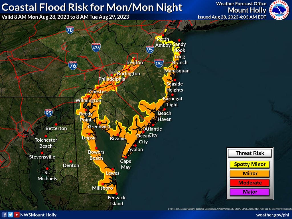
Heavy rainfall is also possible on Tuesday and Tuesday night, which could exacerbate flooding, said the National Weather Service.
As of Monday morning, Franklin is churning offshore north of the Turks and Caicos and could “gain enough wind intensity to become the season's first Category 4 hurricane,” AccuWeather forecasters said.
Idalia sets sights on Florida
Idalia, which strengthened into a tropical storm, is on a potential track to come ashore in western Florida on Wednesday as a Category 1 hurricane. The National Hurricane Center urged residents along Florida's west coast to begin preparing for a hurricane strike on late Tuesday afternoon or evening. Between 5 and 8 feet of seawater could swamp parts of the Tampa Bay area, forecasters said.
Idalia’s impact could be felt later this week up the eastern seaboard and may complicate Labor Day vacation plans for some. Based on current models, the storm will not impact New Jersey too heavily, forecasters said.
The National Weather Service added that Idalia will move northeast in the vicinity of the Carolinas, though its path "should keep any significant land impacts from the storm to our south."
"Otherwise, the systems should bring some periods of mid and high level cloudiness over southern parts of our forecast area for Thursday along with winds that may be quite breezy out of the (northeast)," said the NWS.
The storm should then move eastward out to sea Thursday night into Friday, forecasters said.
Related article:
Get more local news delivered straight to your inbox. Sign up for free Patch newsletters and alerts.