Weather
Hurricane Florence Won't Directly Hit NJ – But It'll Impact Us
We have a better idea as to how Hurricane Florence will impact New Jersey now that the Category 4 storm is closing in on the East Coast.

Yes, there was talk last week that Hurricane Florence could directly hit New Jersey. Well, you can forget about it.
The National Weather Service says the Category 4 storm packing 100-mph-plus winds is practically destined to slam the North Carolina coast.
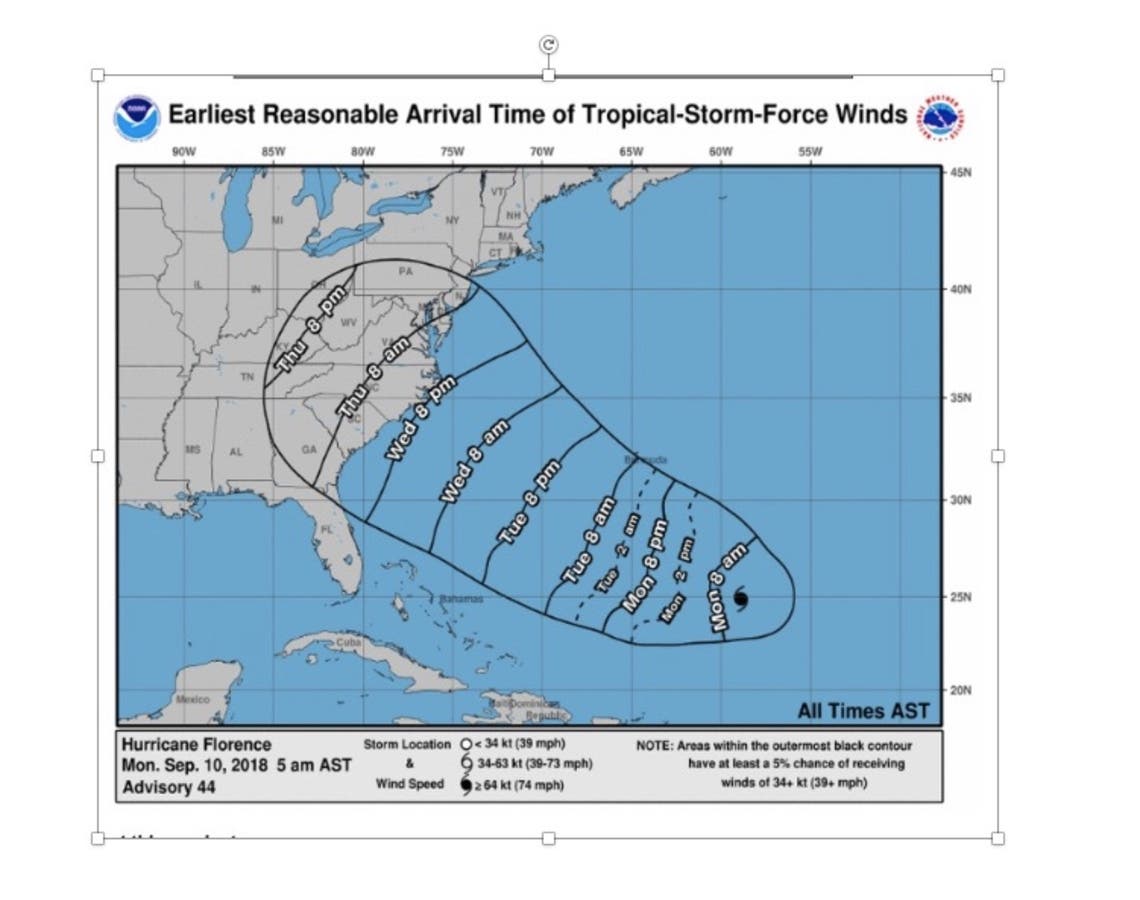
South Jersey has less than a 15 percent chance of even getting tropical-storm-force winds, according to Alex Staarmann, a meteorologist with the National Weather Service in Mount Holly, NJ.
Find out what's happening in Asbury Parkfor free with the latest updates from Patch.
Stay on top of Hurricane Florence news and info. Get free Patch email alerts. Find your Patch town and subscribe.
"What we are likely to get is heavy rainfall and flooding potential," Staarmann told Patch. Rough seas will also cause problems for boaters and, of course, swimmers.
Find out what's happening in Asbury Parkfor free with the latest updates from Patch.
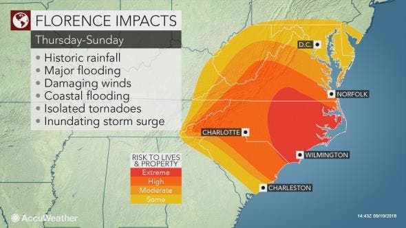
AccuWeather meteorologists say they believe that Florence will reach the North Carolina or Virginia coasts and pose a serious threat to lives and property late this week.
Staarmann said there will be a flooding risk for New Jerseyans since the state has already been dealing with troublesome weather, and the ground is very saturated.
Read more: 6K Without Power, Flooding In NJ As More Storms Expected
If Florence comes ashore as a Category 4 hurricane, damaging winds and power outages may extend inland more than 100 miles, Accuweather said. "Strong high pressure to the north may also enhance winds farther north along the coast than what would normally occur," said AccuWeather Senior Meteorologist Alex Sosnowski.
"As a result, people from southeastern Virginia to southern New Jersey could have damaging winds and significant coastal flooding, even if Florence hovers or moves ashore in North Carolina."
There is the potential for Florence to stall or significantly reduce its forward speed as it nears the coast, which could prolong the effects of damaging winds, storm surge flooding and beach erosion, according to AccuWeather. A stall or slow forward speed would also greatly enhance inland flooding of streams and rivers.
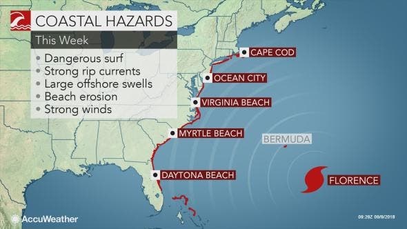
Large swells will propagate outward hundreds of miles away from the center of the storm this week, according to AccuWeather. The exact track, overall size and forward speed of the storm will determine which locations along the coast receive the worst of Florence's damaging winds, heavy rain and storm surge flooding.
Here is the forecast:
- Monday afternoon: Showers likely, with thunderstorms also possible after 3pm. Cloudy, with a high near 73. East wind around 11 mph. Chance of precipitation is 70%. New rainfall amounts between a tenth and quarter of an inch, except higher amounts possible in thunderstorms.
- Monday night: Showers and possibly a thunderstorm, mainly before 10pm, then a chance of showers and thunderstorms after 10pm. Low around 70. East wind 5 to 8 mph becoming south after midnight. Chance of precipitation is 80%. New rainfall amounts between a tenth and quarter of an inch, except higher amounts possible in thunderstorms.
- Tuesday: A chance of showers, then showers and thunderstorms likely after 2pm. Mostly cloudy, with a high near 83. South wind around 5 mph. Chance of precipitation is 60%. New rainfall amounts between a tenth and quarter of an inch, except higher amounts possible in thunderstorms.
- Tuesday night: A chance of showers and thunderstorms. Mostly cloudy, with a low around 69. Light south wind. Chance of precipitation is 40%. New rainfall amounts of less than a tenth of an inch, except higher amounts possible in thunderstorms.
- Wednesday: A chance of showers and thunderstorms. Mostly cloudy, with a high near 83. Calm wind becoming southeast around 5 mph in the afternoon. Chance of precipitation is 50%. New rainfall amounts of less than a tenth of an inch, except higher amounts possible in thunderstorms.
- Wednesday night: A chance of showers and thunderstorms. Mostly cloudy, with a low around 70. Chance of precipitation is 30%. New rainfall amounts of less than a tenth of an inch, except higher amounts possible in thunderstorms.
- Thursday: A chance of showers, with thunderstorms also possible after 8am. Mostly cloudy, with a high near 81. Chance of precipitation is 30%.
- Thursday night: A chance of showers and thunderstorms. Mostly cloudy, with a low around 69. Chance of precipitation is 30%.
- Friday: A chance of showers, with thunderstorms also possible after 8am. Mostly cloudy, with a high near 78. Chance of precipitation is 30%.
NWS photo
Get more local news delivered straight to your inbox. Sign up for free Patch newsletters and alerts.