Weather
NJ Weather: Hazardous Weather Outlook As Weekend Storms Loom
Rough weather is expected in New Jersey as the remnants of Tropical Storm Gordon could have an impact.


Maybe summer in New Jersey isn't over after all, because we could see a repeat this weekend of what we saw for two months.
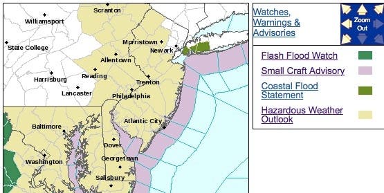
The National Weather Service has issued a hazardous weather outlook New Jersey as the remnants of Tropical Storm Gordon could have an impact on the region.
The NWS says there is a chance for heavy rainfall and localized flooding with one or more rounds of storms on Friday afternoon and evening. Spotty minor tidal flooding is possible with this evening's high tide.
Find out what's happening in Asbury Parkfor free with the latest updates from Patch.
Then there is the potential for locally heavy rain and thunderstorms arriving during the weekend, and then lasting into the early part of the new week. Minor tidal flooding is likely with the high tides on Saturday, Sunday and Monday because of the high astronomical tides associated with the new moon and an onshore wind.
It's too early to tell if Hurricane Florence will have an impact on the area, although meteorologists continued to say on Friday that the category 3 storm may still head toward the Northeast.
Find out what's happening in Asbury Parkfor free with the latest updates from Patch.
Read more: Hurricane Florence Could Be Direct Hit For NJ, Experts Warn
Here are the alerted areas:
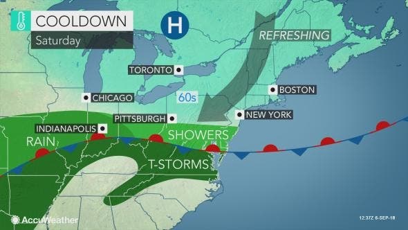
This weekend, AccuWeather says, a break from the summerlike heat is on the horizon, as a blast of cooler and more pleasant air will arrive to end the week and kick off the weekend.
For those with outdoor plans this weekend, Saturday certainly looks like the better day for hiking, biking, fishing and jogging, according to AccuWeather. By Sunday, the weather service says, moisture from what is left of Tropical Rainstorm Gordon will move toward the area and bring periods of showers to the mid-Atlantic with steadier, heavier rain farther inland.
Due to the clouds, rain and chillier winds blowing off the Atlantic Ocean, high temperatures may struggle to get out of the upper 50s in the interior on Sunday with 60s in the I-95 corridor, according to AccuWeather. In a matter of a few days, residents may be trading in the swimwear and light, summer clothing for jackets, rain gear and sweaters.
Warmth and humidity may then continue to build through the middle of next week as Hurricane Florence, currently in the open waters of the Atlantic, pumps the ridge of high pressure back up across the eastern U.S., according to AccuWeather.
Here is the forecast:
- Friday: A chance of showers, with thunderstorms also possible after noon. Cloudy, with a high near 80. Northeast wind 6 to 8 mph. Chance of precipitation is 40%. New rainfall amounts of less than a tenth of an inch, except higher amounts possible in thunderstorms.
- Friday night: A chance of showers and thunderstorms, then showers likely after midnight. Cloudy, with a low around 64. Northeast wind 3 to 6 mph. Chance of precipitation is 60%. New precipitation amounts between a tenth and quarter of an inch, except higher amounts possible in thunderstorms.
- Saturday: Showers likely, mainly before 8am. The rain could be heavy at times. Cloudy, with a high near 73. Northeast wind 8 to 10 mph. Chance of precipitation is 60%. New precipitation amounts between a tenth and quarter of an inch possible.
- Saturday night: A chance of rain. Mostly cloudy, with a low around 61. Northeast wind 7 to 9 mph. Chance of precipitation is 50%. New precipitation amounts of less than a tenth of an inch possible.
- Sunday: A chance of rain. The rain could be heavy at times. Cloudy, with a high near 69. East wind 11 to 15 mph. Chance of precipitation is 50%. New precipitation amounts between a tenth and quarter of an inch possible.
- Sunday night: Rain likely. The rain could be heavy at times. Cloudy, with a low around 61. Chance of precipitation is 60%. New precipitation amounts between a tenth and quarter of an inch possible.
- Monday: A chance of showers, with thunderstorms also possible after 2pm. Cloudy, with a high near 79. Chance of precipitation is 50%.
- Monday night: A chance of showers and thunderstorms. Mostly cloudy, with a low around 69. Chance of precipitation is 50%.
- Tuesday: A chance of showers, with thunderstorms also possible after 2pm. Partly sunny, with a high near 85. Chance of precipitation is 30%.
- Tuesday night: A chance of showers and thunderstorms. Mostly cloudy, with a low around 69. Chance of precipitation is 30%.
- Wednesday: A chance of showers. Partly sunny, with a high near 84. Chance of precipitation is 30%.
- Wednesday night: A chance of showers. Mostly cloudy, with a low around 69. Chance of precipitation is 30%.
- Thursday: A chance of showers. Mostly cloudy, with a high near 82. Chance of precipitation is 30%.
Tom Davis photos
Get more local news delivered straight to your inbox. Sign up for free Patch newsletters and alerts.