Weather
Hurricane Florence Could Hit East Coast, Impact NJ (UPDATED)
UPDATE: The risk of impacts along the East Coast has increased, according to the National Weather Service.


Hurricane Florence is increasingly likely to hit land – with New Jersey possibly in its crosshairs, experts are saying. The state is, at the very least, likely to get some tropical-storm-force winds as the bulk of the storm appears, for the moment, to be heading straight for North Carolina and Virginia.
Meteorologists said there is a chance the Northeastern US, from North Carolina to New England, will be affected. On Monday, forecasters remained committed to that prediction.
Find out what's happening in Manasquan-Belmarfor free with the latest updates from Patch.
"The risk for impacts along the East Coast has increased," according to the National Weather Service, which issued a hazardous weather outlook for New Jersey.
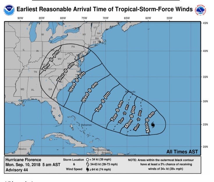
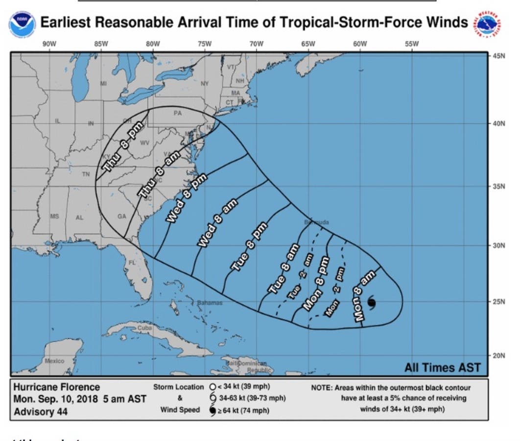
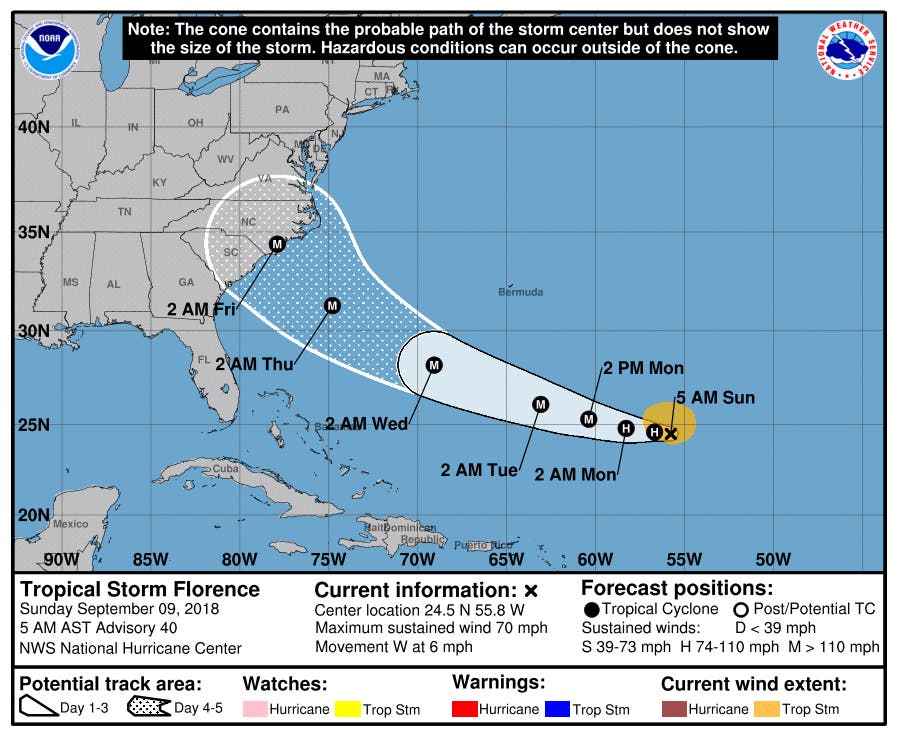
On Monday, Hurricane Florence's winds continued to sir the Atlantic east of Bermuda, according to the National Hurricane Center. It's moving northwest at 12 mph and is expected to retain its status as a hurricane for several days.
Find out what's happening in Manasquan-Belmarfor free with the latest updates from Patch.
It is "forecast to push close enough to Bermuda and the United States East Coast to have indirect impact and may evolve into a serious direct threat," AccuWeather forecaster Alex Sosnowski said in a release.
"At this point anything can happen," said Alex Staarmann, a meteorologist with the National Weather Service in Mount Holly, NJ.
The latest track from the National Hurricane Center brings Florence into the western Atlantic by Wednesday, according to the National Weather Service. At that point, there is still uncertainty with the eventual track of Florence.
At this point, there is the potential for a period of heavy rain and strong winds by the end of next week unless the storm takes a turn out to sea, which still remains a possibility, according to the National Weather Service.
The storm was expected to weaken a little as it passed through a jet stream before restrengthening. Staarmann said there is nothing in the atmosphere, at this point, that could do anything to "demolish" the hurricane before hitting the coast.
Hurricane #Florence hitting stronger upper level winds this morning, weakening it from a category 4 to a 3. Weakening may continue next 24-36 hours as it passes through this jet, then restrengthening expected. Morning models still show large spread in track scenarios next week. pic.twitter.com/iWchna3f7t
— Mike Thomas (@MikeTFox5) September 6, 2018
Sosnowski added, "If the high pressure area remains strong, then Florence may complete a 3,500-mile-long journey over the Atlantic and be guided right into the U.S. East Coast somewhere from the Carolinas to southern New England sometime during Wednesday or Thursday of next week."
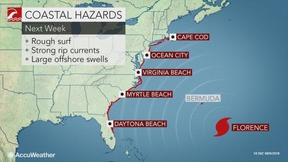
At the least, swells from the storm will begin to hit the East Coast early next week, with the National Hurricane Center warning they will cause life threatening surf and rip currents.
Florence is the first storm above category 3 to form this season and has formed as the Atlantic hurricane season reaches its peak.
Tropical Storm Gordon hit Mississippi Tuesday, with the remnants expected to bring rain to the New Jersey area by next week. Read more: NJ Eyes 2 Storms As Hurricane Season Nears Peak
Here is the forecast:
- Monday: Showers likely before 8am, then showers likely and possibly a thunderstorm between 8am and noon, then showers and thunderstorms likely after noon. Cloudy, with a high near 77. Chance of precipitation is 60%.
- Monday night: A chance of showers and thunderstorms. Mostly cloudy, with a low around 68. Chance of precipitation is 40%.
- Tuesday: A chance of showers and thunderstorms. Partly sunny, with a high near 84. Chance of precipitation is 40%.
- Tuesday night: A chance of showers and thunderstorms. Partly cloudy, with a low around 68. Chance of precipitation is 30%.
- Wednesday: A chance of showers and thunderstorms. Partly sunny, with a high near 83. Chance of precipitation is 30%.
With reporting by Adam Nichols
Lead image by the National Hurricane Center
Get more local news delivered straight to your inbox. Sign up for free Patch newsletters and alerts.