Weather
New Jersey Coastal Storm Update: Swimming Banned; Heavy Wind, Rain Expected
Downpours are expected as a "tropical disturbance" impacts the coast, and a number of beaches are closed to swimming.

Beaches up and down the Jersey Shore have been closed to swimming as a storm expected to produce heavy rain, winds and rough surf works its way up the coast.
A flooding advisory and a hazardous weather outlook has been issued for most of the state as red flags were posted on beaches from Monmouth County all the way down to Cape May. Beach Haven Emergency Management said the ocean is "extremely dangerous."
Many beaches, including Jenkinson's in Point Pleasant Beach and those along Long Beach Island, announced the waters were closed to swimming on Tuesday (see Twitter posts below).
Find out what's happening in Barnegat-Manahawkinfor free with the latest updates from Patch.
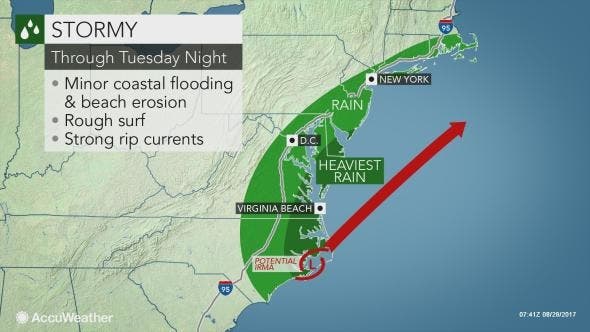
Winds have already begun to whip along the coast as the heaviest rain is expected to hit after 2 p.m. and last until the early morning hours of Wednesday.
The beach conditions are particularly significant given that this summer has been among the deadliest for swimmers in recent memory. Twenty-eight people have died in water-related deaths in New Jersey since May.
Find out what's happening in Barnegat-Manahawkinfor free with the latest updates from Patch.
Read more: 28 Die In New Jersey Water Deaths Since May As Trend Continues
The tropical disturbance, originally dubbed 92L, has been pestering Florida with downpours for nearly a week. Fort Myers, Florida, has received 14.1 inches of rain since Wednesday, Aug. 23, according to an AccuWeather release.
The winds hitting that impact New Jersey could become as punchy as that of a modest nor'easter, according to AccuWeather. Where the winds blow the strongest, from eastern North Carolina to the New Jersey cape, minor beach erosion can occur with minor coastal flooding possible at times of high tide.
It is possible enough rain will fall to cause a few incidents of urban flooding that will far pale in comparison to ongoing events in Texas and southwestern Louisiana due to Harvey, according to AccuWeather.
Here is the forecast:
- Tuesday: Rain. High near 71. East wind 13 to 17 mph, with gusts as high as 28 mph. Chance of precipitation is 100%. New precipitation amounts between a quarter and half of an inch possible.
- Tuesday night: Rain, mainly before 2am. Low around 58. North wind 11 to 14 mph. Chance of precipitation is 100%. New precipitation amounts between a half and three quarters of an inch possible.
- Wednesday: Partly sunny, with a high near 77. North wind 9 to 11 mph.
- Wednesday night: Partly cloudy, with a low around 59. West wind around 6 mph.
- Thursday: A chance of showers and thunderstorms, mainly after 5pm. Mostly sunny, with a high near 84. West wind 7 to 10 mph. Chance of precipitation is 30%. New rainfall amounts of less than a tenth of an inch, except higher amounts possible in thunderstorms.
- Thursday night: A chance of showers and thunderstorms before 8pm. Mostly cloudy, with a low around 52. Chance of precipitation is 30%. New precipitation amounts of less than a tenth of an inch, except higher amounts possible in thunderstorms.
Here are some of the warnings issued by local towns:
Tuesday, August 29th – Due to rough water conditions our beaches are currently RED FLAG, if anything changes we will update. Thank you.
— Jenkinsons Boardwalk (@JenksBoardwalk) August 29, 2017
Wind is increasing is red flag with dangerous rip currents. Plz listen to lifeguards & stay out of water @JSHurricaneNews @GarySzatkowski pic.twitter.com/x9YMIJ4Bn3
— Loch Arbour Beach (@LochArbourBeach) August 29, 2017
Due to dangerous conditions, swimming is prohibited. Rough water is expected over the next few days. Please obey lifeguards pic.twitter.com/RFUPeIbQz3
— HC Beach Patrol (@HCBeachPatrol) August 28, 2017
RED FLAG CONDITIONS: Check with your lifeguard for any change in conditions.
— Ortley Beach (@OBBP_Updates) August 29, 2017
LBTPD: Due to extremely dangerous ocean conditions all Long Beach Twp beaches are red flagged today, no swimming.... https://t.co/HLFEUNqY3J
— Long Beach Township (@LongBeachTwp) August 28, 2017
Photo courtesy of town of Loch Arbour
Get more local news delivered straight to your inbox. Sign up for free Patch newsletters and alerts.