Crime & Safety
Details On Berkeley Area's Snowier, Slicker Forecasts Released For January
Forecasters released details on what's supposed to become a snowier and slicker January.

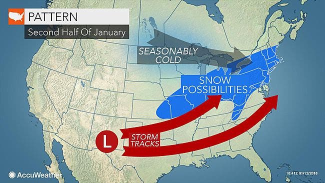
Enough cold air will linger across New Jersey during the latter half of January to increase the chance of snow in areas that have received little so far this season.
A complex storm could bring snow, ice and rain to New Jersey this weekend, followed by another wave of arctic air will sweep southeastward this weekend, according to an AccuWeather release.
With the air starting colder as storms approach, the likelihood of precipitation beginning as snow or a wintry mix in New Jersey will be much greater during the second half of the month than at any point so far this season, AccuWeather says.
Find out what's happening in Berkeleyfor free with the latest updates from Patch.
“In the Midwest, this new blast of arctic air will be as cold as that of the start of this week, but for much of the Northeast it will be coldest of the season so far,” According to AccuWeather Senior Meteorologist Brett Anderson says in the release.
The storm system that is expected to take shape this weekend could saturate New Jersey with rain, starting out and end as a sloppy mix of rain, sleet and snow, according to nj.com.
Find out what's happening in Berkeleyfor free with the latest updates from Patch.
Forecasters who have been analyzing computer models that keep shifting the location of the expected storm track and the range of temperatures told nj.com that the storm could arrive late Friday night into early Saturday morning.
Here is the weekend forecast from the National Weather Service:
Friday night: Rain a possibility throughout N.J. at 7 p.m.
Sunday morning: Snow could arrive in North Jersey by 1 a.m. Snow could arrive in South Jersey by 7 a.m.
Monday morning: Snow could hit Jersey Shore by 1 a.m.
Even as the core of the arctic air settles off the coast over the next week or two, meanwhile, enough cold air may remain behind to allow storms that roll along have greater chances at bringing snow or some sort of wintry precipitation when compared to early winter.
“You don’t need bitterly cold air for it to snow, just cold enough, within a few degrees of freezing,” AccuWeather Chief Long-Range Meteorologist Paul Pastelok said in the release. “We expect temperatures to settle near average during late January in the Midwest and much of the East, which is cold enough for snow.”
While the exact timing and track of storms, which will determine who gets snow versus rain, can be uncertain several days out, there are indications that the pattern will yield more snow opportunities during late January, according to AccuWeather.
“If we look at the overall pattern, there is likely to be a major storm or two with a chance at bringing substantial accumulating snow to portions of the Ohio Valley, I-95 corridor of the mid-Atlantic and southern New England during the third and fourth week of the month,” Pastelok said.
The weight and extent of the cold air could be enough to cause storms to track more to the east and just off the Atlantic coast, instead of northward toward the Great Lakes and Appalachians. With a more southern and eastern storm track, snow could reach areas farther south and east than the first part of the winter.
For portions of the Great Lakes, Appalachians and central and northern New England, multiple storms with enough snow and wintry mix to make for slippery travel are likely for the second half of January. This includes cities such as Chicago, Detroit, Cleveland, Pittsburgh, Boston and Albany, New York, according to AccuWeather.
Get more local news delivered straight to your inbox. Sign up for free Patch newsletters and alerts.