Weather
Hurricane Jose Off New Jersey: Impacts, Location, Timing
Hurricane Jose still presents a threat a New Jersey. Here's a breakdown on what the storm is expected to do, and when.


Hurricane Jose still poses a threat to New Jersey, so forecasters have broken down the potential impacts the state may face once the storm passes over the next few days. Yt's expected to track to the north over the western Atlantic Ocean waters, and east of the East Coast of the United States on Tuesday night and Wednesday.
The outer bands of the storm, however, are expected to pass over the state. The tropical storm watch has been cancelled for all of coastal New Jersey and Delaware but remain in effect for their adjacent coastal waters. Sustained tropical storm-force winds are no longer expected to occur over land.
It will still be breezy at the coast on Tuesday with north to northeast winds 20 to 30 mph and gusts up to 40 mph.
Find out what's happening in Brickfor free with the latest updates from Patch.
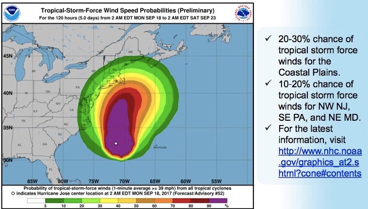
Here's what Jose, packing 85 mph winds at its core, is expected to do in New Jersey:
- Tropical storm-force winds are expected to arrive in Delaware and southern New Jersey Tuesday morning, and then along the coasts in central and northern New Jersey Tuesday afternoon.
- The strongest winds are expected to be confined to to the coast and adjacent waters, with less windy conditions just inland as well.
- The strongest winds should occur Tuesday afternoon through Tuesday evening, and then the winds should fall below Tropical Storm force by early Wednesday morning.
- Coastal flooding will pose a risk to both life and property for the high tide cycles Tuesday, and Tuesday night. In particular, widespread moderate coastal flooding is possible for the ocean front, back bays, and Delaware Bay with the late Tuesday afternoon and Tuesday night high tide cycle.
- Heavy rain is possible Tuesday afternoon and evening and could result in freshwater flooding, mainly for coastal New Jersey.
- Between 1 and 2 inches of rain is forecast for eastern New Jersey from Monday night through Wednesday, but locally heavier amounts are possible, especially Tuesday evening.
- There is also the potential for the storm to shift a bit farther west, and this would bring heavier rain into much of New Jersey as well. If the heavier rain falls at the time of high tide, it could worsen the coastal flooding issues.
- Hazardous seas and dangerous surf resulting in a high risk for the formation of dangerous and life threatening rip currents are expected this week. Significant beach erosion is also expected for much of this week.
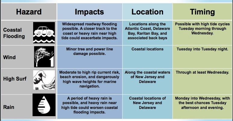
Other potential impacts identified by the National Weather Service include the following:
Find out what's happening in Brickfor free with the latest updates from Patch.
SURGE:
- Prepare for locally hazardous surge having possible limited impacts across coastal portions of Delaware and New Jersey, including the ocean front, back bays, and lower Delaware Bay.
- Localized excessive water is possible with storm surge flooding mainly along immediate shorelines and in low-lying spots, or in areas farther inland near where higher surge waters move ashore.
- Sections of near-shore roads and parking lots could become overspread with surge water. Dangerous driving conditions are possible in places where surge water covers the road.
- Moderate beach erosion is expected. Heavy surf also breaching dunes, mainly in usually vulnerable locations. Strong rip currents are anticipated.
- Minor to locally moderate damage to marinas, docks, boardwalks and piers is possible. A few small craft may be broken away from moorings.
WIND:
- Prepare for hazardous wind having possible limited impacts across New Jersey, Delaware, southeastern Pennsylvania and eastern Maryland.
- Damage to porches, awnings, carports, sheds, and unanchored mobile homes is possible. Unsecured lightweight objects could be blown around.
- Many large tree limbs may be broken off. A few trees could be snapped or uprooted. Some fences and roadway signs may be blown over.
- A few roads could be impassable from debris. Hazardous driving conditions are possible on bridges and other elevated roadways. Scattered power and communications outages are possible.
FLOODING RAIN:
- Prepare for locally hazardous rainfall flooding having possible limited impacts across across northern and eastern New Jersey.
- Localized rainfall flooding may prompt a few evacuations.
- Rivers and tributaries may quickly rise with swifter currents. Small streams, creeks, canals, and ditches may become swollen and overflow in spots.
- Flood waters can enter a few structures, especially in vulnerable spots. Rapid ponding of water may occur at underpasses, low-lying spots, and poor drainage areas. Several storm drains and retention ponds become near-full and begin to overflow. Some brief road and bridge closures are possible.
Also See: Another Hurricane Could Be Headed Toward The Caribbean
Photo: NWS
Get more local news delivered straight to your inbox. Sign up for free Patch newsletters and alerts.